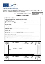
- Page 1:
Visual Impact Study (VIS) of the
- Page 5 and 6:
1 Introduction 1.1 Background to th
- Page 7 and 8:
1.3 Structure of the study The stud
- Page 9:
In the time allowed for the study (
- Page 12 and 13:
12 1200 Castle on the Taschenberg 1
- Page 14 and 15:
14 1694 -1733 Augustus the Strong p
- Page 16 and 17:
16 Figures 2.3, 2.4 Boundaries of t
- Page 18 and 19:
18 Sites are ‚works of man or the
- Page 20 and 21:
20 Figure 3.1 Boundaries of the spe
- Page 22 and 23:
22 1850 1910 1940 1992 Figure 3.2 M
- Page 24 and 25:
24 Figure 3.3 Dresden city map, 189
- Page 26 and 27:
26 Figure 3.6 Adolf Lohse, Schloß
- Page 28 and 29:
28 Figure 3.8 Theodor Lehnert, Phot
- Page 30 and 31:
30 Figure 3.10 Development plan, No
- Page 32 and 33:
32 Figure 3.11 Theodor Friedrich, p
- Page 34 and 35:
34 Figure 3.12 Plan of the Elbe riv
- Page 36 and 37:
36 Figure 3.13 Festival hall for th
- Page 38 and 39:
38 Figure 3.14 Visual relationships
- Page 40:
40 Figure 3.16 Lookout points in th
- Page 43 and 44:
created lookout points must be give
- Page 45 and 46:
4 Perception and depiction of the s
- Page 47 and 48:
in Meißen” by Eberhard Kieser an
- Page 49 and 50:
for the national press when making
- Page 51 and 52:
Robert Geissler’s lithograph, pro
- Page 53 and 54:
4.3 Conclusion Evidently, artists f
- Page 55 and 56:
5 The planned “Verkehrszug Waldsc
- Page 57 and 58:
Plan 1862 Plan 1891 Plan 1898 5.1 H
- Page 59 and 60:
Plan 1900 Plan 1905 Plan 1934 see f
- Page 61 and 62: Plan 1967 “Between 1960 and 1970,
- Page 63 and 64: crossing somewhere in the Dresden m
- Page 65 and 66: nach 1945 [Road and Traffic History
- Page 67 and 68: fare, in particular its gradient. (
- Page 69 and 70: 5.3 Building specifications for the
- Page 71 and 72: current Käthe-Kollwitz-Ufer route
- Page 73 and 74: The bottom chords below the bridge
- Page 75 and 76: idge pylons were enlarged by expand
- Page 77 and 78: Marien Bridge The Marien Bridge des
- Page 79 and 80: The Old Carola Bridge The Old Carol
- Page 81 and 82: etween Übigau (Washington Strasse)
- Page 83 and 84: 5.5 Conclusion When the longitudina
- Page 85 and 86: 6 Analysis of field-of-view impact
- Page 87 and 88: c. the 3D model of the design of th
- Page 89 and 90: using GPS co-ordinates. This techni
- Page 91 and 92: entire panorama. The field-of-view
- Page 93 and 94: The best method of realistically si
- Page 95 and 96: Source: author’s illustration/aer
- Page 97 and 98: entire panorama. It can be assumed,
- Page 99 and 100: South Bank 09. Dome of the Frauenki
- Page 101 and 102: View Sequences 1. Sequence A Elbe v
- Page 103 and 104: Details 1. Stauffenbergerallee In S
- Page 105 and 106: Waldschlösschen pavilion, the Elbe
- Page 107 and 108: Because of the currently complex si
- Page 109 and 110: 7 Conclusions/Recommendations It is
- Page 111: as the effect of diffuse winter lig
- Page 115 and 116: Text sources / Image sources Aussch
- Page 117 and 118: Kultur- und Naturerbes der Welt von
- Page 119: Imprint Commissioned by Dr. Roland