versión preliminar - Instituto de Investigaciones de la Amazonía ...
versión preliminar - Instituto de Investigaciones de la Amazonía ...
versión preliminar - Instituto de Investigaciones de la Amazonía ...

You also want an ePaper? Increase the reach of your titles
YUMPU automatically turns print PDFs into web optimized ePapers that Google loves.
108<br />
Programa <strong>de</strong> Investigación para el Or<strong>de</strong>namiento Ambiental (POA)<br />
Cuadro 01: Imágenes compradas en el INPE Cuadro 01: Imágenes adquiridas <strong>de</strong> <strong>la</strong> Web‐<br />
en el INPE<br />
Nº Base/P<br />
onto<br />
Data/Passagem Formato<br />
1 4/62 2007‐07‐29 GEOTIFF<br />
2 4/63 2007‐07‐29 GEOTIFF<br />
3 5/62 2006‐05‐14 GEOTIFF<br />
4 5/63 2006‐05‐14 GEOTIFF<br />
5 6/61 2005‐08‐22 GEOTIFF<br />
6 6/62 2005‐08‐22 GEOTIFF<br />
7 6/63 2005‐08‐22 GEOTIFF<br />
8 6/64 2005‐08‐22 GEOTIFF<br />
9 6/65 2006‐08‐25 GEOTIFF<br />
10 6/66 2006‐08‐25 GEOTIFF<br />
11 7/62 2005‐08‐13 GEOTIFF<br />
12 7/63 2005‐08‐13 GEOTIFF<br />
13 7/64 2005‐08‐13 GEOTIFF<br />
14 7/65 2005‐08‐29 GEOTIFF<br />
<strong>Instituto</strong> <strong>de</strong> <strong>Investigaciones</strong> <strong>de</strong> <strong>la</strong> <strong>Amazonía</strong> Peruana | Memoria 2008<br />
Nº FECHA PATH‐ROW FORMATO<br />
1 03/10/2008 004‐063 GEOTIFF<br />
2 04/06/2008 005‐062 GEOTIFF<br />
3 24/09/2008 005‐062 GEOTIFF<br />
4 24/09/2008 005‐063 GEOTIFF<br />
5 14/08/2008 006‐066 GEOTIFF<br />
6 04/09/2007 007‐060 GEOTIFF<br />
7 08/02/2007 007‐061 GEOTIFF<br />
8 04/09/2007 007‐061 GEOTIFF<br />
9 29/08/2005 007‐066 GEOTIFF<br />
10 12/08/2008 008‐060 GEOTIFF<br />
11 12/08/2008 008‐061 GEOTIFF<br />
12 12/08/2008 008‐062 GEOTIFF<br />
13 12/08/2008 008‐063 GEOTIFF<br />
14 12/08/2008 008‐064 GEOTIFF<br />
15 18/09/2007 009‐062 GEOTIFF<br />
16 15/09/2006 009‐063 GEOTIFF<br />
17 18/09/2007 009‐064 GEOTIFF<br />
Las imágenes fueron procesadas en el programa Erdas 9.1., convirtiéndolos <strong>de</strong> formato TIFF al<br />
formato IMG, para posteriormente juntar <strong>la</strong>s 7 bandas <strong>de</strong> cada imagen.<br />
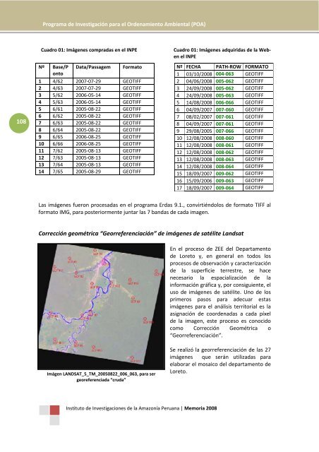
Corrección geométrica “Georreferenciación” <strong>de</strong> imágenes <strong>de</strong> satélite Landsat<br />
Imágen LANDSAT_5_TM_20050822_006_063, para ser<br />
georeferenciada “cruda”<br />
En el proceso <strong>de</strong> ZEE <strong>de</strong>l Departamento<br />
<strong>de</strong> Loreto y, en general en todos los<br />
procesos <strong>de</strong> observación y caracterización<br />
<strong>de</strong> <strong>la</strong> superficie terrestre, se hace<br />
necesario <strong>la</strong> espacialización <strong>de</strong> <strong>la</strong><br />
información gráfica y, por consiguiente, el<br />
uso <strong>de</strong> imágenes <strong>de</strong> satélite. Uno <strong>de</strong> los<br />
primeros pasos para a<strong>de</strong>cuar estas<br />
imágenes para el análisis territorial es <strong>la</strong><br />
asignación <strong>de</strong> coor<strong>de</strong>nadas a cada píxel<br />
<strong>de</strong> <strong>la</strong> imagen, este proceso es conocido<br />
como Corrección Geométrica o<br />
“Georreferenciación”.<br />
Se realizó <strong>la</strong> georreferenciación <strong>de</strong> <strong>la</strong>s 27<br />
imágenes que serán utilizadas para<br />
e<strong>la</strong>borar<br />
el mosaico <strong>de</strong>l <strong>de</strong>partamento <strong>de</strong><br />
Loreto.