lots 1 - 321 in PDF - Loeb Larocque
lots 1 - 321 in PDF - Loeb Larocque
lots 1 - 321 in PDF - Loeb Larocque
- No tags were found...

Create successful ePaper yourself
Turn your PDF publications into a flip-book with our unique Google optimized e-Paper software.
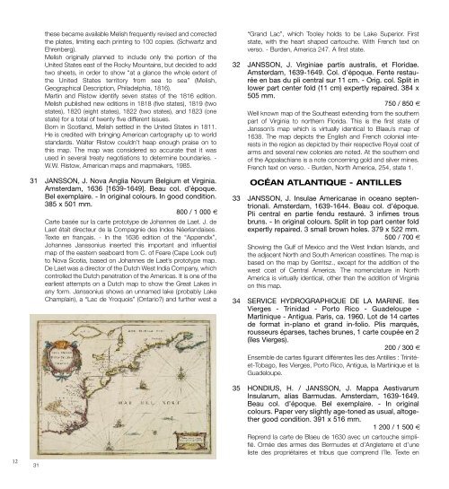
12these became available melish frequently revised and correctedthe plates, limit<strong>in</strong>g each pr<strong>in</strong>t<strong>in</strong>g to 100 copies. (Schwartz andEhrenberg).melish orig<strong>in</strong>ally planned to <strong>in</strong>clude only the portion of theUnited States east of the Rocky mounta<strong>in</strong>s, but decided to addtwo sheets, <strong>in</strong> order to show “at a glance the whole extent ofthe United States territory from sea to sea” (melish,Geographical Description, Philadelphia, 1816).mart<strong>in</strong> and Ristow identify seven states of the 1816 edition.melish published new editions <strong>in</strong> 1818 (five states), 1819 (twostates), 1820 (eight states), 1822 (two states), and 1823 (onestate) for a total of twenty five different issues.Born <strong>in</strong> Scotland, melish settled <strong>in</strong> the United States <strong>in</strong> 1811.He is credited with br<strong>in</strong>g<strong>in</strong>g American cartography up to worldstandards. Walter Ristow couldn’t heap enough praise on tothis map. the map was considered so accurate that it wasused <strong>in</strong> several treaty negotiations to determ<strong>in</strong>e boundaries. -W.W. Ristow, American maps and mapmakers, 1985.31 JANSSON, J. Nova Anglia Novum Belgium et Virg<strong>in</strong>ia.Amsterdam, 1636 [1639-1649]. Beau col. d’époque.Bel exemplaire. - In orig<strong>in</strong>al colours. In good condition.385 x 501 mm.800 / 1 000 €Carte basée sur la carte prototype de Johannes de Laet. J. deLaet était directeur de la Compagnie des <strong>in</strong>des Néerlandaises.texte en français. - <strong>in</strong> the 1636 edition of the “Appendix”,Johannes Janssonius <strong>in</strong>serted this important and <strong>in</strong>fluentialmap of the eastern seaboard from C. of Feare (Cape Look out)to Nova Scotia, based on Johannes de Laet’s prototype map.De Laet was a director of the Dutch West <strong>in</strong>dia Company, whichcontrolled the Dutch penetration of the Americas. it is one of theearliest attempts on a Dutch map to show the Great Lakes <strong>in</strong>any form. Janssonius shows an unnamed lake (probably LakeChampla<strong>in</strong>), a “Lac de Yroquois” (Ontario?) and further west a31“Grand Lac”, which tooley holds to be Lake Superior. Firststate, with the heart shaped cartouche. With French text onverso. - Burden, America 247. A first state.32 JANSSON, J. Virg<strong>in</strong>iae partis australis, et Floridae.Amsterdam, 1639-1649. Col. d’époque. Fente restauréeen bas du pli central sur 11 cm. - Orig. col. Split <strong>in</strong>lower part center fold (11 cm) expertly repaired. 384 x505 mm.750 / 850 €Well known map of the Southeast extend<strong>in</strong>g from the southernpart of Virg<strong>in</strong>ia to northern Florida. this is the first state ofJansson’s map which is virtually identical to Blaeu’s map of1638. the map depicts the English and French colonial <strong>in</strong>terests<strong>in</strong> the region as depicted by their respective Royal coat ofarms and several new colonies are noted. At the southern endof the Appalachians is a note concern<strong>in</strong>g gold and silver m<strong>in</strong>es.French text on verso. - Burden, North America, 254, state 1.OCÉAN ATLANTIQUE - ANTILLES33 JANSSON, J. Insulae Americanae <strong>in</strong> oceano septentrionali.Amsterdam, 1639-1644. Beau col. d’époque.Pli central en partie fendu restauré. 3 <strong>in</strong>fimes trousbruns. - In orig<strong>in</strong>al colours. Split <strong>in</strong> top part center foldexpertly repaired. 3 small brown holes. 379 x 522 mm.500 / 700 €Show<strong>in</strong>g the Gulf of mexico and the West <strong>in</strong>dian islands, andthe adjacent North and South American coastl<strong>in</strong>es. the map isbased on the map by Gerritsz., except for the addition of thewest coat of Central America. the nomenclature <strong>in</strong> NorthAmerica is virtually identical, other than the addition of Virg<strong>in</strong>iaon this map.34 SERVICE HYDROGRAPHIQUE DE LA MARINE. IlesVierges - Tr<strong>in</strong>idad - Porto Rico - Guadeloupe -Mart<strong>in</strong>ique - Antigua. Paris, ca. 1960. Lot de 14 cartesde format <strong>in</strong>-plano et grand <strong>in</strong>-folio. Plis marqués,rousseurs éparses, taches brunes, 1 carte coupée en 2(îles Vierges).200 / 300 €Ensemble de cartes figurant différentes îles des Antilles : tr<strong>in</strong>itéet-tobago,iles Vierges, Porto Rico, Antigua, la mart<strong>in</strong>ique et laGuadeloupe.35 HONDIUS, H. / JANSSON, J. Mappa AestivarumInsularum, alias Barmudas. Amsterdam, 1639-1649.Beau col. d’époque. Bel exemplaire. - In orig<strong>in</strong>alcolours. Paper very slightly age-toned as usual, altogethergood condition. 391 x 516 mm.1 200 / 1 500 €Reprend la carte de Blaeu de 1630 avec un cartouche simplifié.Ornée des armes des Bermudes et d’Angleterre et d’uneliste des propriétaires et tribus que comprend l’île. texte en