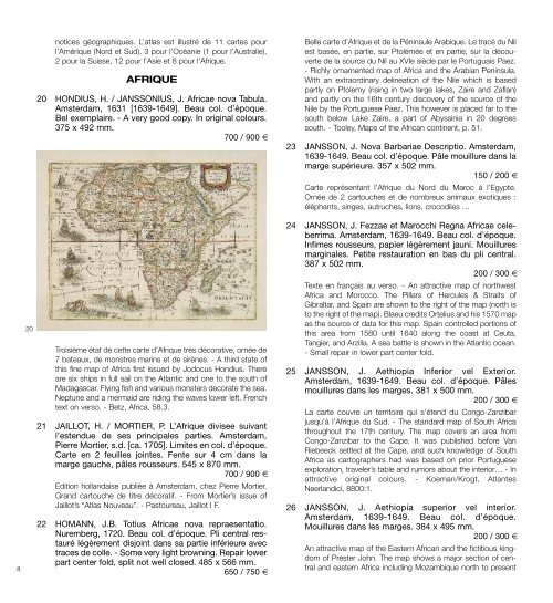
820notices géographiques. L’atlas est illustré de 11 cartes pourl’Amérique (Nord et Sud), 3 pour l’Océanie (1 pour l’Australie),2 pour la Suisse, 12 pour l’Asie et 8 pour l’Afrique.AFRIQUE20 HONDIUS, H. / JANSSONIUS, J. Africae nova Tabula.Amsterdam, 1631 [1639-1649]. Beau col. d’époque.Bel exemplaire. - A very good copy. In orig<strong>in</strong>al colours.375 x 492 mm.700 / 900 €troisième état de cette carte d’Afrique très décorative, ornée de7 bateaux, de monstres mar<strong>in</strong>s et de sirènes. - A third state ofthis f<strong>in</strong>e map of Africa first issued by Jodocus Hondius. thereare six ships <strong>in</strong> full sail on the Atlantic and one to the south ofmadagascar. Fly<strong>in</strong>g fish and various monsters decorate the sea.Neptune and a mermaid are rid<strong>in</strong>g the waves lower left. Frenchtext on verso. - Betz, Africa, 58.3.21 JAILLOT, H. / MORTIER, P. L’Afrique divisee suivantl’estendue de ses pr<strong>in</strong>cipales parties. Amsterdam,Pierre Mortier, s.d. [ca. 1705]. Limites en col. d’époque.Carte en 2 feuilles jo<strong>in</strong>tes. Fente sur 4 cm dans lamarge gauche, pâles rousseurs. 545 x 870 mm.700 / 900 €Edition hollandaise publiée à Amsterdam, chez Pierre mortier.Grand cartouche de titre décoratif. - From mortier’s issue ofJaillot’s “Atlas Nouveau”. - Pastoureau, Jaillot i F.22 HOMANN, J.B. Totius Africae nova repraesentatio.Nuremberg, 1720. Beau col. d’époque. Pli central restaurélégèrement disjo<strong>in</strong>t dans sa partie <strong>in</strong>férieure avectraces de colle. - Some very light brown<strong>in</strong>g. Repair lowerpart center fold, split not well closed. 485 x 566 mm.650 / 750 €Belle carte d’Afrique et de la Pén<strong>in</strong>sule Arabique. Le tracé du Nilest basée, en partie, sur Ptolémée et en partie, sur la découvertede la source du Nil au XVie siècle par le Portuguais Paez.- Richly ornamented map of Africa and the Arabian Pen<strong>in</strong>sula.With an extraord<strong>in</strong>ary del<strong>in</strong>eation of the Nile which is basedpartly on Ptolemy (ris<strong>in</strong>g <strong>in</strong> two large lakes, Zaire and Zaflan)and partly on the 16th century discovery of the source of theNile by the Portuguese Paez. this however is placed far to thesouth below Lake Zaire, a part of Abyss<strong>in</strong>ia <strong>in</strong> 20 degreessouth. - tooley, maps of the African cont<strong>in</strong>ent, p. 51.23 JANSSON, J. Nova Barbariae Descriptio. Amsterdam,1639-1649. Beau col. d’époque. Pâle mouillure dans lamarge supérieure. 357 x 502 mm.150 / 200 €Carte représentant l’Afrique du Nord du maroc à l’Egypte.Ornée de 2 cartouches et de nombreux animaux exotiques :éléphants, s<strong>in</strong>ges, autruches, lions, crocodiles …24 JANSSON, J. Fezzae et Marocchi Regna Africae celeberrima.Amsterdam, 1639-1649. Beau col. d’époque.Infimes rousseurs, papier légèrement jauni. Mouilluresmarg<strong>in</strong>ales. Petite restauration en bas du pli central.387 x 502 mm.200 / 300 €texte en français au verso. - An attractive map of northwestAfrica and morocco. the Pillars of Hercules & Straits ofGibraltar, and Spa<strong>in</strong> are shown to the right of the map (north isto the right of the map). Blaeu credits Ortelius and his 1570 mapas the source of data for this map. Spa<strong>in</strong> controlled portions ofthis area from 1580 until 1640 along the coast at Ceuta,tangier, and Arzilla. A sea battle is shown <strong>in</strong> the Atlantic ocean.- Small repair <strong>in</strong> lower part center fold.25 JANSSON, J. Aethiopia Inferior vel Exterior.Amsterdam, 1639-1649. Beau col. d’époque. Pâlesmouillures dans les marges. 381 x 500 mm.200 / 300 €La carte couvre un territoire qui s’étend du Congo-Zanzibarjusqu’à l’Afrique du Sud. - the standard map of South Africathroughout the 17th century. the map covers an area fromCongo-Zanzibar to the Cape. it was published before VanRiebeeck settled at the Cape, and such knowledge of SouthAfrica as cartographers had was based on prior Portugueseexploration, traveler’s table and rumors about the <strong>in</strong>terior… - <strong>in</strong>attractive orig<strong>in</strong>al colours. - Koeman/Krogt, AtlantesNeerlandici, 8800:1.26 JANSSON, J. Aethiopia superior vel <strong>in</strong>terior.Amsterdam, 1639-1649. Beau col. d’époque.Mouillures dans les marges. 384 x 495 mm.200 / 300 €An attractive map of the Eastern African and the fictitious k<strong>in</strong>gdomof Prester John. the map shows a major section of centraland eastern Africa <strong>in</strong>clud<strong>in</strong>g mozambique north to present
28day Sudan the map conta<strong>in</strong>s numerous coastal place namessuch as mozambique island, Quiloa, mombaza, and mel<strong>in</strong>de<strong>in</strong>dicat<strong>in</strong>g the importance of the area to both Arab, Portuguese,and traders and explorers from ther countries. - Paper slightlyage-toned as usual. marg<strong>in</strong>al water sta<strong>in</strong><strong>in</strong>g. <strong>in</strong> attractive orig<strong>in</strong>alcolour<strong>in</strong>g. - Koeman/Krogt, Atlantes Neerlandici, [8720: 1B].27 BELLIN, J.N. Carte de l’Isle de Bourbon. Paris, 1763.Carte et cartouche coloriés. Encadré. Bel exemplaire.560 x 710 mm.500 / 700 €Carte de l’isle de Bourbon Dressée au Dépôt des Cartes etPlans de la mar<strong>in</strong>e Par Ordre de m. Le Duc de Choiseul,Colonel-général des Suisses et Grisons, m<strong>in</strong>istre de la Guerre etde la mar<strong>in</strong>e.ARCHIVES DE L’ETHNOGRAPHE ET CARTOGRAPHEEUGÈNE DE FROBERVILLE28 FROBERVILLE, Eugène de. Ensemble de cartes surMadagascar. ca. 1845. Très bon état général. Lescartes sur calque, étant donné leur fragilité, présententparfois des déchirures ou des manques.3 000 / 5 000 €Eugène de Froberville (né le 14.11.1815 à maurice - mort le20.04.1904 à Villelouet (41)). Ethnographe, l<strong>in</strong>guiste et cartographe,Eugène de Froberville rédigea un long essai <strong>in</strong>troductifà l’ouvrage de B.F. Leguével de Lacombe « Voyage àmadagascar et aux îles Comores (1823 à 1830) par B.F.Leguével de Lacombe, précédé d’une notice historique et géographiquesur madagascar, par m. Eugène de Froberville… ».B.F. Leguével de Lacombe était un voyageur qui, dans lesannées 1820, a passé huit ans sur la côte Est de l’Afrique, auxÎles Comores et à madagascar. Cet ouvrage en deux volumesest son compte rendu sur la population, l’économie et la culturede madagascar. Froberville apporta également sa contributionau Bullet<strong>in</strong> de la Société de Géographie. En effet, au milieu desannées 1840, il entreprit sous l’égide de la Société deGéographie un voyage en Afrique orientale af<strong>in</strong> d’y mener uneétude ethnographique. il étudia les peuples, leurs coutumes,leurs langues a<strong>in</strong>si que le mécanisme de la traite et du commercedes esclaves, il publia également 2 cartes.Archives de l’ethnographe et cartographe Eugène de Froberville.Ce remarquable ensemble comprend des cartes gravées, unimportant lot de cartes manuscrites sur calque a<strong>in</strong>si que desnotes sur madagascar, les Comores, les Seychelles et laRéunion.- Les cartes manuscrites sur calque réalisées par Eugène deFroberville reprennent les travaux d’autres voyageurs et sontannotées par lui. il reprend notamment les cartes dess<strong>in</strong>ées parle cartographe et géologue Jean-Baptiste Lislet Geoffroy a<strong>in</strong>sique celles réalisées par le Capita<strong>in</strong>e Owen qui à la suite d’uneexploration de quatre années (1821-1826), publia à Londresune relation de voyage sur les côtes de l’Afrique orientale,depuis la baie de Delagoa jusqu’en Arabie, à madagascar etaux Seychelles. D’autres encore sont des brouillons d’étude oudes esquisses par Froberville lui-même. Certa<strong>in</strong>es cartes sontdans un très grand format et décrivent tout ou partie de l’île demadagascar. Cette importante iconographie est une sourced’<strong>in</strong>formation remarquable et regroupe vraisemblablementtoutes les cartes et données connues jusque là.- Les cartes gravées sont en majorité des cartes éditées par le« Dépôt Général de la mar<strong>in</strong>e » ou par l « Hydrographical Officeof the Admiralty » sous la direction du Captn. W.F. Owen. Enoutre, une diza<strong>in</strong>e de cartes de format Grand Aigle ou réaliséessur 2 ou 3 feuilles complètent cet ensemble.- Plus de 40 cartes de format <strong>in</strong>-plano et quelques unes pluspetites, éditées par le « Dépôt Général de la mar<strong>in</strong>e », figurentles côtes de madagascar, les maldives, les Seychelles, lesComores et la Réunion. Environ 11 cartes proviennent du «Neptune oriental » publié par d’Après de mannevillette. Un lotde cartes d’Afrique et de régions d’Afrique publiées au XiX e sièclevient compléter l’ensemble des cartes françaises.- Deux cartes (en double) par Froberville : « Esquisse des Payssitués entre les Fleuves de Luvûma et de Lufidzi (Afrique orientale)d’après les relations des <strong>in</strong>digènes par mr. Eugène deFromerville. ile maurice. 1847 » / « tableau synoptique <strong>in</strong>diquantla parenté analogique des langues de l’Afrique méridionale. Parmr. Eugène de Fromerville. 1851. »- trois cartes sont annotées au crayon « Carte de l’OcéanAtlantique Septentrional », «Carte de l’Océan Atlantiqueméridional » et « Carte générale de la mer des <strong>in</strong>des » - et <strong>in</strong>diquentdes it<strong>in</strong>éraires de voyages depuis la France. L’un d’euxdébute en 1845 sur le bateau « La Céres », le trajet suit lescôtes de l’Afrique occidentale vers l’Océan <strong>in</strong>dien, passe par LaRéunion, l’île maurice, Ceylan, la mer Rouge et se term<strong>in</strong>e àSuez en 1847.- Environ 46 cartes de format <strong>in</strong>-plano et <strong>in</strong>-4 éditées par l «9
- Page 1 and 2: VENDREDI 9 NOVEMBRE 2012 À 14H15HO
- Page 3 and 4: CURIOSITÉS1 21 BÜNTING, H. Asia s
- Page 5 and 6: glypties sont des reproductions d
- Page 7: tassin en inséra d’autres, qui l
- Page 11 and 12: 30wormholes in the “Mississippi t
- Page 13 and 14: français au verso. - Based closely
- Page 15 and 16: 53 JANSSON, J. Indiae Orientalis No
- Page 17 and 18: Gravé à madrid sous la direction
- Page 19 and 20: 80 SAGANSAN, L. Carte des Chemins d
- Page 21 and 22: 8790 COLLIN. Carte militaire des en
- Page 23 and 24: ÎLE-DE-FRANCE99 GUCHEN, (Maximin)
- Page 25 and 26: légèrement jauni le long du pli c
- Page 27 and 28: PAYS BASQUE132 DÉPÔT GÉNÉRAL DE
- Page 29 and 30: totype même étant le canal de Bri
- Page 31 and 32: Employé par le duc d’Angoulême,
- Page 33 and 34: 180 BALZAC, Honoré de. Le Lys dans
- Page 35 and 36: 189 BERANGER, P.J. de. Chansons anc
- Page 37 and 38: 195 CONTES GALANTS EN VERS. Recueil
- Page 39 and 40: 207 GOBINEAU, Arthur de. Nouvelles
- Page 41 and 42: 216 LA FONTAINE, Jean de. Fables ch
- Page 43 and 44: 224 LOTI, Pierre. Fantôme d’Orie
- Page 45 and 46: 233 MAUPASSANT, Guy De. L’inutile
- Page 47 and 48: 250 RICHEPIN, Jean. La Chanson des
- Page 49 and 50: 258 VULSON DE LA COLOMBIERE, Marc d
- Page 51 and 52: PAUL DUVAL DIT JEAN LORRAIN (1855-1
- Page 53 and 54: 274 LORRAIN, Jean. (Paul Duval dit)
- Page 55 and 56: DE LA COLLECTION D’UN AMATEUR282
- Page 57 and 58: 285285 JAMMES, Francis & GRAU SALA.
- Page 59 and 60:
BEAUX-ARTS - DIVERS291 ALAUX (Jean-
- Page 61 and 62:
308 MAÎTRES DE L’ART (Les). Ense
- Page 63 and 64:
Ventes aux Enchères - ExpertisesOR