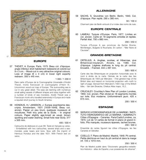
ALLEMAGNE59 SACHS, S. Grundriss von Berl<strong>in</strong>. Berl<strong>in</strong>, 1840. Col.d’époque. Plan replié. 290 x 380 mm.50 / 100 €Charmant plan de Berl<strong>in</strong> entouré d’un <strong>in</strong>dex des noms de rues.EUROPE CENTRALE60 LAMEAU. Turquie d’Europe. Paris, 1877. Limites encol. ancien. Carte en 18 segments entoilée et repliée.Parfait état. 700 x 880 mm.200 / 250 €turquie d’Europe & ses prov<strong>in</strong>ces de Serbie Bosnie,monténégro, Bulgarie & Roumanie. En carton : “mer Noire etCaucase”.1657EUROPE57 THEVET, A. Europe. Paris, 1575. Beau col. d’époque.angle <strong>in</strong>férieur droit habilement redess<strong>in</strong>é et colorié sur9 x 3 cm. - Wood-cut <strong>in</strong> very attractive orig<strong>in</strong>al colours.Loss of image (9 x 3 cm) <strong>in</strong> lower right expertlyredrawn. 350 x 445 mm.1 000 / 1 200 €Rare carte d’Europe de la Cosmographie Universelle d’Andréthevet, mo<strong>in</strong>e francisca<strong>in</strong> et cosmographe d’Henri iii.-Uncommon wood-cut map of Europe. the surround<strong>in</strong>g sea iscut <strong>in</strong> very great detail. the seas are teem<strong>in</strong>g with numeroussmall sail<strong>in</strong>g vessels of different shapes and sizes together witha number of k<strong>in</strong>ds of sea monsters. André thevet was aFranciscan monk who travelled extensively <strong>in</strong> Europe and madea reputed short journey to South America.58 HONDIUS, H./ JANSSON, J. Europa exactissime descripta.Amsterdam, 1631 [1639-1649]. Beau col.ancien. Papier un peu bruni, quelques rousseurs etmouillures. Petit trou près de la Sicile. - In orig<strong>in</strong>alcolours. Paper slightly age-toned as usual, brownspott<strong>in</strong>g and water sta<strong>in</strong><strong>in</strong>g. Small hole near Sicily. 377x 505 mm.400 / 500 €Cartouche de dédicace à Louis Xiii. texte en français au verso.- Embellished with two cartouches, several ships and a seamonster,polar bears and lions. Now with the impr<strong>in</strong>t ofHenricus Hondius and the date 1631. With French text onverso.GRANDE-BRETAGNE61 ORTELIUS, A. Angliae, scotiae, et Hiberniae, siveBritannicar:<strong>in</strong>sularum. Anvers, ca. 1580. Col.d’époque. Légères éraflures le long du pli central.Encadré. - Framed. 344 x 497 mm.500 / 600 €Carte des iles Britanniques en projection horizontale avec lenord à droite de la carte. Dérivée de la carte des ilesBritanniques de 1564 par mercator. - F<strong>in</strong>e general map of theBritish isles and ireland on horizontal projection with north toright of page. Derived from mercator’s 1564 map of the Britishisles. - Van den Broecke, Ortelius Atlas maps, 16.2.62 CRUCHLEY. Cruchley’s New Plan of London Londres,1850. Col. ancien. Plan divisé en 18 segments montéssur toile. Etui moderne. Uniformément jauni. 420 x615 mm.200 / 300 €ESPAGNE63 SERVICE HYDROGRAPHIQUE DE LA MARINE / INSTI-TUTO HIDROGRAFICO DE LA MARINA / ADMIRALTY.Côtes d’Espagne - Canaries. Paris/Cadiz/Londres, ca.1970. Lot de 12 cartes de format <strong>in</strong>-plano et grand <strong>in</strong>folio.Plis marqués, rousseurs éparses, taches brunes.200 / 300 €Ensemble de cartes figurant les côtes d’Espagne, les îlesCanaries et Gibraltar.64 COELLO, F. Plano de Madrid. Madrid, 1849. Pli central.Petite déchirure en haut du pli central et dans la marge<strong>in</strong>f. 725 x 1010 mm.250 / 300 €Plan de madrid publié dans “Diccionario geografico-estadistico-historico: atlas de España y sus posesiones de ultramar”.
Gravé à madrid sous la direction de Juan Noguera, le trait et latopographie par Decorbie et Leclerq, la lettre par Bacot.65 SERVICE HYDROGRAPHIQUE DE LA MARINE. IlesBaléares - Ivice et Formentora. Paris, ca. 1970. Neufcartes de format <strong>in</strong>-plano et grand <strong>in</strong>-folio. Plis marqués,rousseurs éparses.200 / 300 €Lot de 9 cartes figurant les îles Baléares, la baie de Palma, iviceet Formentora, les ports et mouillages des îles majorque et ivice.66 JANSSON, J. Insulae Balearides et Pytiusae.Amsterdam, 1639-1649. Col. d’époque. Pli centralfendu entièrement consolidé, 2 déchirures de 5 cm enhaut et en bas du pli central restaurées. - In orig<strong>in</strong>alcolours. Paper slightly age-toned. Split along centerfold totally re<strong>in</strong>forced. With repair of 2 small holes and2 horizontal tears at center fold, 5 cm <strong>in</strong>to engravedarea. 382 x 500 mm.200 / 300 €Carte des Baléares ornée d’un cartouche, d’une échelle dedeux armoiries, de 3 bateaux, de deux roses des vents et demonstres mar<strong>in</strong>s. texte en français au verso. - French text onverso.GRÈCE67 BARBIE DU BOCAGE. Carte de la Morée. Paris, 1814.Carte en 24 segments entoilé et repliée. Chemise etétui modernes. Pâle auréole brune en bas de carte.575 x 930 mm.300 / 400 €Carte de la morée dressée et gravée au Dépôt Gl. de la Guerrepar ordre du Gouvernement en 1807 publiée à Paris en 1814.Gravé au Dépôt Gal. De la Guerre par A. Blondeau. En cartons: Plan du Canal des Dardanelles de Lépante, Plan du Portde Navar<strong>in</strong>s, Plan de l’isthme de Cor<strong>in</strong>the. Accompagnéed’une “Remarque sur la construction de la Carte de la morée”.MEDITERRANÉE68 JAILLOT, A.H. La Mer Méditerranée divisée en sesPr<strong>in</strong>cipales Parties ou Mers. Paris, s.d. [ca. 1700]. Beaucol. d’époque. Carte en 2 feuilles jo<strong>in</strong>tes. Petite fentedans la marge gauche. Bel exemplaire. 540 x 865 mm.700 / 800 €Carte par Sanson publiée par Jaillot ou mortier. Date grattée.Grand cartouche décoratif.ITALIE69 JANSSON, J. Siciliae veteris typus. Paris, 1639-1649.Col. d’époque. Papier bruni. - Paper very slightly browned.381 x 485 mm.150 / 200 €Carte représentant la Sicile antique. Gravée par Abraham Goos,elle est ornée de 2 cartouches figurant un globe, Neptune avecses dauph<strong>in</strong>s, des anges et un aigle. En carton : Port et ville deSyracuse. - map with two decorative cartouches featur<strong>in</strong>g aglobe, Neptune and his dolph<strong>in</strong>s, angels and an eagle. Large<strong>in</strong>set of the harbor and city of Syracuse, conta<strong>in</strong>ed <strong>in</strong> a thirddecorative cartouche.70 SCHMETTAU, Samuel von / ORCEL, Gian Giuseppe.Descrizione Geografica del Regno di Sicilia e sue IsoleAdiacenti. 1779. Limites en col. d’époque. Carte diviséeen 32 segments entoilés à l’époque. Un petit morceaude la carte (2,5 x 4 cm) le long des pliures médianes aété recollé, <strong>in</strong>fime manque à gauche le long de la pliuremédiane. Très belle impression. 905 x 1240 mm.1 200 / 1 500 €magnifique réédition de la carte de S. von Schmettau de 1748,publiée par G.G. Orcel et gravée par Garofalo. Ornée d’un beaucartouche de titre et d’un carton comprenant Pantellaria, Gozzoet malta. - A later version of Schmettau’s 1748 map of Sicily.Pr<strong>in</strong>ted from four plates. Published by G.G. Orcel, engraved byGarofalo. <strong>in</strong>set of Pantellaria and malta with Gozo. -Lagum<strong>in</strong>a/Dufour, imago Siciliae, p. 312.Voir la reproduction en page 2 de la couverture71 SERVICE HYDROGRAPHIQUE DE LA MARINE / INSTI-TUTO HIDROGRAFICO DE LA MARINA / ADMIRALTY.De l’île d’Elbe à Naples. Paris, 1967. Pli central. 635 x955 mm.30 / 50 €6772 UGHI, Ludovico. Nuova Pianta dell’Inclita Citta diVenezia Regolata l’Anno 1787. Venise, LodovicoLurlanetto, 1787. Plan divisé en 30 segments montéssur toile. Déchirure de la toile en haut à droite, bords de4 segments un peu froissés et salis, petites tachesd’humidité. 515 x 680 mm.900 / 1 000 €17
- Page 1 and 2: VENDREDI 9 NOVEMBRE 2012 À 14H15HO
- Page 3 and 4: CURIOSITÉS1 21 BÜNTING, H. Asia s
- Page 5 and 6: glypties sont des reproductions d
- Page 7 and 8: tassin en inséra d’autres, qui l
- Page 9 and 10: 28day Sudan the map contains numero
- Page 11 and 12: 30wormholes in the “Mississippi t
- Page 13 and 14: français au verso. - Based closely
- Page 15: 53 JANSSON, J. Indiae Orientalis No
- Page 19 and 20: 80 SAGANSAN, L. Carte des Chemins d
- Page 21 and 22: 8790 COLLIN. Carte militaire des en
- Page 23 and 24: ÎLE-DE-FRANCE99 GUCHEN, (Maximin)
- Page 25 and 26: légèrement jauni le long du pli c
- Page 27 and 28: PAYS BASQUE132 DÉPÔT GÉNÉRAL DE
- Page 29 and 30: totype même étant le canal de Bri
- Page 31 and 32: Employé par le duc d’Angoulême,
- Page 33 and 34: 180 BALZAC, Honoré de. Le Lys dans
- Page 35 and 36: 189 BERANGER, P.J. de. Chansons anc
- Page 37 and 38: 195 CONTES GALANTS EN VERS. Recueil
- Page 39 and 40: 207 GOBINEAU, Arthur de. Nouvelles
- Page 41 and 42: 216 LA FONTAINE, Jean de. Fables ch
- Page 43 and 44: 224 LOTI, Pierre. Fantôme d’Orie
- Page 45 and 46: 233 MAUPASSANT, Guy De. L’inutile
- Page 47 and 48: 250 RICHEPIN, Jean. La Chanson des
- Page 49 and 50: 258 VULSON DE LA COLOMBIERE, Marc d
- Page 51 and 52: PAUL DUVAL DIT JEAN LORRAIN (1855-1
- Page 53 and 54: 274 LORRAIN, Jean. (Paul Duval dit)
- Page 55 and 56: DE LA COLLECTION D’UN AMATEUR282
- Page 57 and 58: 285285 JAMMES, Francis & GRAU SALA.
- Page 59 and 60: BEAUX-ARTS - DIVERS291 ALAUX (Jean-
- Page 61 and 62: 308 MAÎTRES DE L’ART (Les). Ense
- Page 63 and 64: Ventes aux Enchères - ExpertisesOR