Urban Poverty & Climate Change in Dar es Salaam, Tanzania:
Urban Poverty & Climate Change in Dar es Salaam, Tanzania:
Urban Poverty & Climate Change in Dar es Salaam, Tanzania:

Create successful ePaper yourself
Turn your PDF publications into a flip-book with our unique Google optimized e-Paper software.
displays the major zon<strong>es</strong>. Natural vegetation ma<strong>in</strong>ly <strong>in</strong>clud<strong>es</strong> coastal palm grov<strong>es</strong>, coastal<br />
shrubs, Miombo woodland, coastal swamps, and swampy mangrove tre<strong>es</strong> and reeds.<br />
Prolonged human <strong>in</strong>terference has reduced the diversity of woodland and scrub.<br />
2.2 <strong>Climate</strong><br />
2.2.1 <strong>Climate</strong> overview<br />
<strong>Dar</strong> <strong>es</strong> <strong>Salaam</strong> is a coastal city. It receiv<strong>es</strong> over 1,000 mm of ra<strong>in</strong>fall per year and has a<br />
bimodal ra<strong>in</strong>fall distribution, the two ma<strong>in</strong> ra<strong>in</strong> seasons be<strong>in</strong>g the long ra<strong>in</strong>s and the short<br />
ra<strong>in</strong>s, associated with southward and northwards movements r<strong>es</strong>pectively of the Inter-<br />
Tropical Convergence Zone (ITCZ). The long ra<strong>in</strong>s season (Masika) occurs from mid<br />
March to end May, and the short ra<strong>in</strong>s (Vuli) from mid October to late December.<br />
Although June to September is typically a dry season for most parts of the country,<br />
coastal areas tend to receive a small amount of ra<strong>in</strong>fall over this period. Ra<strong>in</strong>fall <strong>in</strong><br />
<strong>Tanzania</strong> is <strong>in</strong>fluenced by the southeast monsoon w<strong>in</strong>ds (May–September), the northeast<br />
monsoons (October–March), El-N<strong>in</strong>o Southern Oscillation (ENSO), tropical cyclon<strong>es</strong>,<br />
easterly wav<strong>es</strong> and the Congo air mass. Land and sea breez<strong>es</strong> along the Indian Ocean<br />
coast play a large role <strong>in</strong> modify<strong>in</strong>g the spatial and temporal distribution of ra<strong>in</strong>fall over<br />
coastal regions such as <strong>Dar</strong> <strong>es</strong> <strong>Salaam</strong>, Zanzibar, Pemba and Tanga.<br />
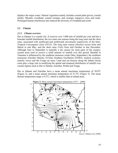
<strong>Dar</strong> <strong>es</strong> <strong>Salaam</strong> and Zanzibar have a mean annual maximum temperature of 30.8 o C<br />
(Figure 2), and a mean annual m<strong>in</strong>imum temperature of 21.3 o C (Figure 3). The mean<br />
diurnal temperature range is 9.2 o C, which is smaller than <strong>in</strong> <strong>in</strong>land areas.<br />
S<br />
1<br />
2<br />
3<br />
4<br />
5<br />
6<br />
7<br />
8<br />
9<br />
10<br />
11<br />
12<br />
Figure 2: Mean annual maximum temperature (1971 – 2000)<br />
Kigoma<br />
Bukoba<br />
Sumbawanga<br />
Mwanza<br />
Tabora<br />
Musoma<br />
Mbeya<br />
S<strong>in</strong>gida<br />
Igeri<br />
Dodoma<br />
Songea<br />
Lyamungu<br />
Moshi<br />
Arusha Kilimanjaro<br />
Ir<strong>in</strong>ga<br />
Ilonga<br />
Same<br />
Morogoro<br />
Ml<strong>in</strong>gano<br />
Tanga<br />
Zanzibar<br />
Mafia<br />
Pemba<br />
<strong>Dar</strong> <strong>es</strong> <strong>Salaam</strong><br />
L<strong>in</strong>di<br />
Mtwara<br />
30 31 32 33 34 35 36 37 38 39 40 41<br />
E<br />
Source: Matari et al. (2008)<br />
19