Creating a Map with ArcMap - Tufts University
Creating a Map with ArcMap - Tufts University
Creating a Map with ArcMap - Tufts University

Create successful ePaper yourself
Turn your PDF publications into a flip-book with our unique Google optimized e-Paper software.
Downloading image data from MassGIS<br />
• Now go online and go the MassGIS web site: http://www.mass.gov/mgis/<br />
• Click on the Download Free Data link<br />
• There is information here about how to download if you need it. If you are familiar <strong>with</strong><br />
downloading files, go the Download Image Data link and read about the available imagery and<br />
scroll down the page to see what is available. You are going to download a 1:5,000 Digital Ortho<br />
Image for 2005 and a Scanned 1:25,000 USGS Topographic Quad Image (DRG)<br />
• In the 1:5,000 Digital Ortho Image (2005) section, click on the link for MrSid – MrSid is an<br />
image compression format that retains good resolution<br />
• You will see all the files for Massachusetts - scroll down to find the sheet id you want and select<br />
all the files <strong>with</strong> that sheet-id<br />
• Download these to your personal folder along <strong>with</strong> your other GIS data by right clicking on each<br />
file and selecting “save link as” – you MUST get all the files <strong>with</strong> the sheet-id – the .sid file is the<br />
image itself, the .sdw file is the file that gives it the correct location, and the .aux file helps it to<br />
draw quickly. The files will take several minutes to download<br />
• Now go back to the image data web page and download the same sheet-ID for the Scanned<br />
1:25,000 USGS Topographic Quad – again, use the MrSID link (note that the quad maps start <strong>with</strong><br />
the letter “q” but have the same sheet ID after that).<br />
• Download the .sid, .sdw, and the .aux files beginning <strong>with</strong> q233902 by right-clicking on each file<br />
and selecting “save link as”<br />
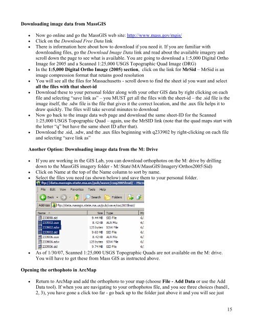
Another Option: Downloading image data from the M: Drive<br />
• If you are working in the GIS Lab, you can download orthophotos on the M: drive by drilling<br />
down to the MassGIS imagery folder - M:\State\MA\MassGIS\Imagery\Orthos2005\Sid)<br />
• Click on Name at the top of the Name column to sort by name.<br />
• Select the files you need (as shown below) and save them to your personal folder.<br />
• As of 1/30/07, Scanned 1:25,000 USGS Topographic Quads are not available on the M: drive.<br />
You will have to get these from Mass GIS as instructed above.<br />
Opening the orthophoto in Arc<strong>Map</strong><br />
• Return to Arc<strong>Map</strong> and add the orthophoto to your map (choose File - Add Data or use the Add<br />
Data tool). If when you are navigating to your orthophotos file, and you see three choices (band1,<br />
2, 3), you have gone a click too far - go back up to the folder just above it and you will see just<br />
15