Creating a Map with ArcMap - Tufts University
Creating a Map with ArcMap - Tufts University
Creating a Map with ArcMap - Tufts University

You also want an ePaper? Increase the reach of your titles
YUMPU automatically turns print PDFs into web optimized ePapers that Google loves.
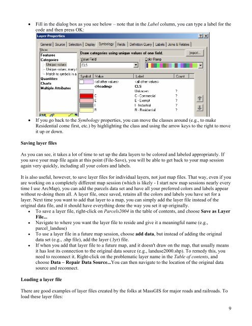
• Fill in the dialog box as you see below – note that in the Label column, you can type a label for the<br />
code and then press OK:<br />
• If you go back to the Symbology properties, you can move the classes around (e.g., to make<br />
Residential come first, etc.) by highlighting the class and using the arrow keys to the right to move<br />
it up or down.<br />
Saving layer files<br />
As you can see, it takes a lot of time to set up the data layers to be colored and labeled appropriately. If<br />
you save your map file again at this point (File-Save), you will be able to get back to your map session<br />
again very quickly, including all your colors and labels.<br />
It is also useful, however, to save layer files for individual layers, not just map files. That way, even if you<br />
are working on a completely different map session (which is likely - I start new map sessions nearly every<br />
time I use Arc<strong>Map</strong>), you can add the parcels data set and have all your preferred colors and labels appear<br />
<strong>with</strong>out re-doing them all. A layer file, once saved, retains all the colors and labels you have set for a<br />
layer. Next time you want to add that layer to a map, you can simply add the layer file instead of the<br />
original data file, and it should have everything done the way you set it up originally.<br />
• To save a layer file, right-click on Parcels2004 in the table of contents, and choose Save as Layer<br />
File...<br />
• Navigate to where you want the layer file to reside and give it a meaningful name (e.g.,<br />
parcel_landuse)<br />
• To use a layer file in a future map session, choose add data, but instead of adding the original<br />
data set (e.g., .shp file), add the layer (.lyr) file.<br />
• If when you add that layer file to a future map, and it doesn't draw on the map, that usually means<br />
it has lost its connection to the original data source (e.g., landuse2000.shp). To remedy this, you<br />
need to reconnect it. Right-click on the problematic layer name in the Table of contents, and<br />
choose Data – Repair Data Source...You can then navigate to the location of the original data<br />
source and reconnect.<br />
Loading a layer file<br />
There are good examples of layer files created by the folks at MassGIS for major roads and railroads. To<br />
load these layer files:<br />
9