Creating a Map with ArcMap - Tufts University
Creating a Map with ArcMap - Tufts University
Creating a Map with ArcMap - Tufts University

You also want an ePaper? Increase the reach of your titles
YUMPU automatically turns print PDFs into web optimized ePapers that Google loves.
• Turn on the town boundary labels.<br />
• Now go to Layout view (View - Layout View) and you will see both data frames in the layout.<br />
• You can select one data frame for moving or resizing by using the Select pointer icon ( ). Play<br />
around <strong>with</strong> moving and resizing data frames. To switch data frames, you must select it <strong>with</strong> the<br />
pointer icon. This is what can get confusing, but when you finally get the hang of it, it can be a<br />
very powerful tool.<br />
• In Layout view, you can activate one of the data frames by double-clicking on it. For example, say<br />
you want to set the scale of one data frame to 1:24,000 and the other data frame to 1:100,000.<br />
Double-click on the first one, and set the scale, then double-click on the second one to set the scale<br />
for that one.<br />
• Try making a small locator map using a second data frame - it should have the major roads, town<br />
boundaries, and rivers in it.<br />
• As you play, make sure you save your map file, preferably under a new name so that if you mess<br />
up you can reload an earlier version.<br />
Setting up a locator boundary box<br />
If you have two data frames, including one that is a locator map for the larger map (e.g., the Boston area),<br />
you can set up a boundary as in the graphic map example earlier. To do this:<br />
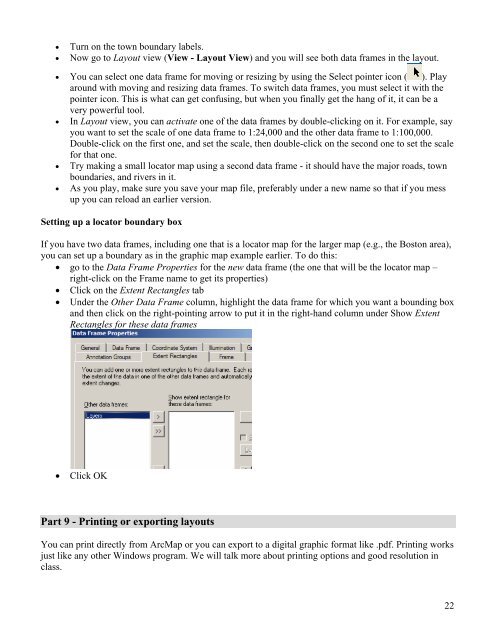
• go to the Data Frame Properties for the new data frame (the one that will be the locator map –<br />
right-click on the Frame name to get its properties)<br />
• Click on the Extent Rectangles tab<br />
• Under the Other Data Frame column, highlight the data frame for which you want a bounding box<br />
and then click on the right-pointing arrow to put it in the right-hand column under Show Extent<br />
Rectangles for these data frames<br />
• Click OK<br />
Part 9 - Printing or exporting layouts<br />
You can print directly from Arc<strong>Map</strong> or you can export to a digital graphic format like .pdf. Printing works<br />
just like any other Windows program. We will talk more about printing options and good resolution in<br />
class.<br />
22