Creating a Map with ArcMap - Tufts University
Creating a Map with ArcMap - Tufts University
Creating a Map with ArcMap - Tufts University

You also want an ePaper? Increase the reach of your titles
YUMPU automatically turns print PDFs into web optimized ePapers that Google loves.
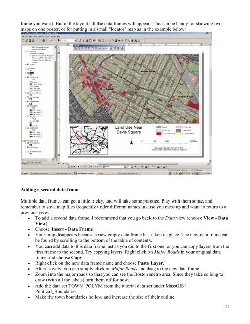
frame you want). But in the layout, all the data frames will appear. This can be handy for showing two<br />
maps on one poster, or for putting in a small "locator" map as in the example below:<br />
Adding a second data frame<br />
Multiple data frames can get a little tricky, and will take some practice. Play <strong>with</strong> them some, and<br />
remember to save map files frequently under different names in case you mess up and want to return to a<br />
previous view.<br />
• To add a second data frame, I recommend that you go back to the Data view (choose View - Data<br />
View).<br />
• Choose Insert - Data Frame<br />
• Your map disappears because a new empty data frame has taken its place. The new data frame can<br />
be found by scrolling to the bottom of the table of contents.<br />
• You can add data to this data frame just as you did to the first one, or you can copy layers from the<br />
first frame to the second. Try copying layers. Right click on Major Roads in your original data<br />
frame and choose Copy<br />
• Right click on the new data frame name and choose Paste Layer.<br />
• Alternatively, you can simply click on Major Roads and drag to the new data frame.<br />
• Zoom into the major roads so that you can see the Boston metro area. Since they take so long to<br />
draw (<strong>with</strong> all the labels) turn them off for now.<br />
• Add the data set TOWN_POLYM from the tutorial data set under MassGIS \<br />
Political_Boundaries.<br />
• Make the town boundaries hollow and increase the size of their outline.<br />
21