EVEREST June, 2013 - California Department of Boating and ...
EVEREST June, 2013 - California Department of Boating and ...
EVEREST June, 2013 - California Department of Boating and ...

Create successful ePaper yourself
Turn your PDF publications into a flip-book with our unique Google optimized e-Paper software.
Orange County Coastal Regional Sediment Management Plan<br />
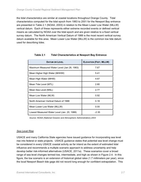
the tidal characteristics are similar at coastal locations throughout Orange County. Tidal<br />
characteristics computed for the tidal epoch from 1983 to 2001 for the Newport Bay entrance<br />
are presented in Table 2.1 (NOAA, 2003) in relation to the Mean Lower Low Water (MLLW)<br />
vertical datum. Each <strong>of</strong> these represents either extreme recorded events or defined vertical<br />
means as calculated by NOAA over the tidal epoch <strong>and</strong> are given relative to a fixed vertical<br />
survey datum. The North American Vertical Datum <strong>of</strong> 1988 is the most recent vertical survey<br />
datum available for this area. Mean Lower Low Water (MLLW) is the common low tide datum<br />
used for describing tides.<br />
Table 2.1<br />
Tidal Characteristics at Newport Bay Entrance<br />
DATUM OR LEVEL<br />
ELEVATION (FEET, MLLW)<br />
Maximum Measured Water Level (Jan 28, 1983) 7.67<br />
Mean Higher High Water (MHHW) 5.41<br />
Mean High Water (MHW) 4.67<br />
Mean Tide Level (MTL) 2.80<br />
Mean Sea Level (MSL) 2.77<br />
Mean Low Water (MLW) 0.92<br />
North American Vertical Datum <strong>of</strong> 1988 0.18<br />
Mean Lower Low Water (MLLW) 0.00<br />
Lowest Measured Water Level (Jan. 20, 1988) -2.35<br />
Source: NOAA (National Oceanic <strong>and</strong> Atmospheric Administration),2003<br />
Sea Level Rise<br />
USACE <strong>and</strong> many <strong>California</strong> State agencies have issued guidance for incorporating sea level<br />
rise into federal or state projects. USACE guidance states that potential sea level change must<br />
be considered in every USACE coastal activity as far inl<strong>and</strong> as the extent <strong>of</strong> estimated tidal<br />
influence <strong>and</strong> recommends a multiple scenario approach to address uncertainty <strong>and</strong> help<br />
develop better risk-informed alternatives (USACE, 2011a). These scenarios cover a broad<br />
range <strong>of</strong> sea level changes termed low, intermediate, <strong>and</strong> high as shown in Figure 2.4. In this<br />
figure, the low scenario is an extension <strong>of</strong> historical global rates (1.7 millimeters per year), since<br />
the local Newport Beach tide gage did not record long enough for confident extrapolation. This<br />
Everest International Consultants, Inc. 2.7