EVEREST June, 2013 - California Department of Boating and ...
EVEREST June, 2013 - California Department of Boating and ...
EVEREST June, 2013 - California Department of Boating and ...

Create successful ePaper yourself
Turn your PDF publications into a flip-book with our unique Google optimized e-Paper software.
Orange County Coastal Regional Sediment Management Plan<br />
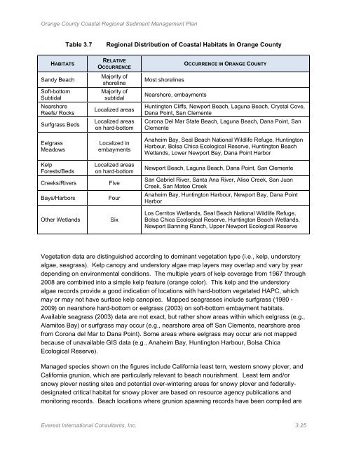
Table 3.7<br />
Regional Distribution <strong>of</strong> Coastal Habitats in Orange County<br />
HABITATS<br />
S<strong>and</strong>y Beach<br />
S<strong>of</strong>t-bottom<br />
Subtidal<br />
Nearshore<br />
Reefs/ Rocks<br />
Surfgrass Beds<br />
Eelgrass<br />
Meadows<br />
Kelp<br />
Forests/Beds<br />
Creeks/Rivers<br />
Bays/Harbors<br />
Other Wetl<strong>and</strong>s<br />
RELATIVE<br />
OCCURRENCE<br />
Majority <strong>of</strong><br />
shoreline<br />
Majority <strong>of</strong><br />
subtidal<br />
Localized areas<br />
Localized areas<br />
on hard-bottom<br />
Localized in<br />
embayments<br />
Localized areas<br />
on hard-bottom<br />
Five<br />
Four<br />
Six<br />
Most shorelines<br />
Nearshore, embayments<br />
OCCURRENCE IN ORANGE COUNTY<br />
Huntington Cliffs, Newport Beach, Laguna Beach, Crystal Cove,<br />
Dana Point, San Clemente<br />
Corona Del Mar State Beach, Laguna Beach, Dana Point, San<br />
Clemente<br />
Anaheim Bay, Seal Beach National Wildlife Refuge, Huntington<br />
Harbour, Bolsa Chica Ecological Reserve, Huntington Beach<br />
Wetl<strong>and</strong>s, Lower Newport Bay, Dana Point Harbor<br />
Newport Beach, Laguna Beach, Dana Point, San Clemente<br />
San Gabriel River, Santa Ana River, Aliso Creek, San Juan<br />
Creek, San Mateo Creek<br />
Anaheim Bay, Huntington Harbour, Newport Bay, Dana Point<br />
Harbor<br />
Los Cerritos Wetl<strong>and</strong>s, Seal Beach National Wildlife Refuge,<br />
Bolsa Chica Ecological Reserve, Huntington Beach Wetl<strong>and</strong>s,<br />
Newport Banning Ranch, Upper Newport Ecological Reserve<br />
Vegetation data are distinguished according to dominant vegetation type (i.e., kelp, understory<br />
algae, seagrass). Kelp canopy <strong>and</strong> understory algae map layers may overlap <strong>and</strong> vary by year<br />
depending on environmental conditions. The multiple years <strong>of</strong> kelp coverage from 1967 through<br />
2008 are combined into a simple kelp feature (orange color). This kelp <strong>and</strong> the understory<br />
algae records provide a good indication <strong>of</strong> locations with hard-bottom vegetated HAPC, which<br />
may or may not have surface kelp canopies. Mapped seagrasses include surfgrass (1980 -<br />
2009) on nearshore hard-bottom or eelgrass (2003) on s<strong>of</strong>t-bottom embayment habitats.<br />
Available seagrass (2003) data are not exact, but rather show areas within which eelgrass (e.g.,<br />
Alamitos Bay) or surfgrass may occur (e.g., nearshore area <strong>of</strong>f San Clemente, nearshore area<br />
from Corona del Mar to Dana Point). Some areas where eelgrass may occur are not mapped<br />
because <strong>of</strong> unavailable GIS data (e.g., Anaheim Bay, Huntington Harbour, Bolsa Chica<br />
Ecological Reserve).<br />
Managed species shown on the figures include <strong>California</strong> least tern, western snowy plover, <strong>and</strong><br />
<strong>California</strong> grunion, which are particularly relevant to beach nourishment. Least tern <strong>and</strong>/or<br />
snowy plover nesting sites <strong>and</strong> potential over-wintering areas for snowy plover <strong>and</strong> federallydesignated<br />
critical habitat for snowy plover are based on resource agency publications <strong>and</strong><br />
monitoring records. Beach locations where grunion spawning records have been compiled are<br />
Everest International Consultants, Inc. 3.25