Knowsley Replacement Unitary Development Plan - Knowsley Council
Knowsley Replacement Unitary Development Plan - Knowsley Council
Knowsley Replacement Unitary Development Plan - Knowsley Council

Create successful ePaper yourself
Turn your PDF publications into a flip-book with our unique Google optimized e-Paper software.
TRANSPORT<br />
TRANSPORT<br />
POLICY LINKS<br />
Policy G1<br />
“<strong>Development</strong> within the Green Belt”<br />
Policy DQ1<br />
“Design Quality in New <strong>Development</strong>”<br />
Policy DQ2<br />
“Security in the Built Environment”<br />
Policy T8<br />
“Transport Assessments”<br />
Policy T10<br />
“Access for the Less Mobile”<br />
Policy ENV2<br />
“Noise and Vibration”<br />
Policy ENV3<br />
“Light Pollution”<br />
Policy MW7<br />
“Renewable Energy”<br />
POLICY T4:<br />
MAJOR HIGHWAY SCHEMES<br />
1. The following major highway schemes are<br />
indicated on the Proposals Map:<br />
a) The improvement of the junction of the<br />
M62/M57/A5300 junction (the “Tarbock<br />
Interchange”); and<br />
b) The provision of a new link road to serve<br />
the South Prescot Action Area.<br />
2. The <strong>Council</strong> will use its powers as Local<br />
<strong>Plan</strong>ning Authority to support the<br />
implementation of these schemes within the<br />
<strong>Plan</strong> period.<br />
EXPLANATION T4<br />
8.21<br />
The Proposals Map identifies the broad location of<br />
land likely to be required for two important<br />
highway schemes.<br />
8.22<br />
The improvement of the M62/M57/A5300 junction (the<br />
“Tarbock Interchange”) is scheduled for<br />
implementation in the period before 2011, and is<br />
likely to involve the creation of new slip roads linking<br />
the M62 and the M57. The scheme is being<br />
progressed by the Highways Agency, and its<br />
implementation will support the delivery of key<br />
development opportunities on Merseyside.<br />
The scheme will also aim to improve safety and<br />
reduce congestion on the strategic road network.<br />
The final details of the scheme, and therefore<br />
the precise location of land affected, have yet<br />
to be determined.<br />
8.23<br />
The new link road in Prescot is required to provide<br />
adequate access to the strategic highway network to<br />
support the <strong>Council</strong>’s proposals for the South Prescot<br />
Action Area. <strong>Plan</strong>ning permission has already been<br />
granted for the scheme, which will be carried out in<br />
several phases, along the alignment shown on the<br />
Proposals Map. These phases will be timed to<br />
coincide with critical stages in the redevelopment of<br />
the Action Area, to ensure that sufficient highway<br />
capacity is generated to provide adequate access at<br />
all times for freight and other vehicles likely to visit<br />
the Action Area, and to discourage the use of<br />
Manchester Road (which runs through a<br />
residential area).<br />
8.24<br />
Also a new road from Upton Rocks residential<br />
development (in Widnes) to Cronton Road (at a point<br />
just within <strong>Knowsley</strong>’s boundary) has already been<br />
granted planning permission.<br />
POLICY LINKS<br />
Policy EC5<br />
“South Prescot Action Area”<br />
POLICY T5:<br />
LOCATION OF MAJOR TRAFFIC GENERATING<br />
NEW DEVELOPMENT<br />
1. Major developments (as defined in table 8.1)<br />
should be or be capable of being located within<br />
safe and convenient walking distance of public<br />
transport facilities (defined as being no more<br />
than 400 metres from a bus stop and/or 800<br />
metres from a rail station or Merseytram stop).<br />
2. <strong>Development</strong>s that are likely to generate<br />
significant movement of freight or other<br />
vehicular traffic should be located at sites,<br />
which have good access to, and which will not<br />
cause an unacceptable amount of congestion<br />
on the rail network or the Strategic Road<br />
Network as indicated on the Proposals Map.<br />
3. Where a site for a proposed major<br />
development is not already within safe and<br />
convenient walking distance of a station, stop<br />
or interchange on passenger rail, bus or tram<br />
networks, planning permission will only be<br />
granted if improvements to the public<br />
transport network are made. There may also<br />
be a requirement for improvements to the<br />
Strategic Road Network. All such<br />
improvements should be made prior to the<br />
completion of the development to provide for<br />
satisfactory accessibility for all.<br />
EXPLANATION T5<br />
8.25<br />
The location of development can have a significant<br />
impact on travel patterns, influencing both the<br />
number and length of journeys generated and also<br />
the choice of travel mode. Government planning<br />
policy requires that major developments, likely to<br />
attract significant numbers of visitors, can be easily<br />
accessed by walking, cycling and public transport.<br />
The objective is to provide realistic alternatives<br />
to the car.<br />
8.26<br />
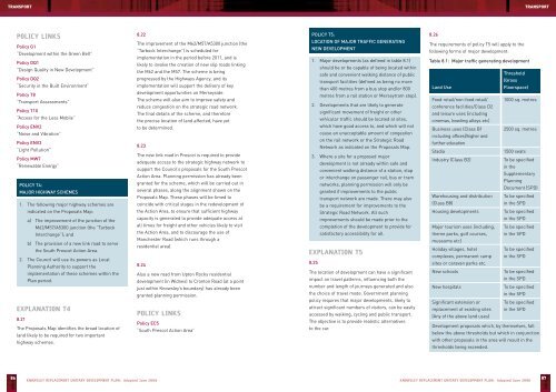
The requirements of policy T5 will apply to the<br />
following forms of major development:<br />
Table 8.1: Major traffic generating development<br />
Threshold<br />
(Gross<br />
Land Use<br />
Floorspace)<br />
Food retail/non-food retail/ 1000 sq. metres<br />
conference facilities/Class D2<br />
and leisure uses (including<br />
cinemas, bowling alleys etc)<br />
Business uses (Class B1 2500 sq. metres<br />
including offices)/higher and<br />
further education<br />
Stadia<br />
1500 seats<br />
Industry (Class B2)<br />
To be specified<br />
in the<br />
Supplementary<br />
<strong>Plan</strong>ning<br />
Document (SPD)<br />
Warehousing and distribution To be specified<br />
(Class B8)<br />
in the SPD<br />
Housing developments<br />
To be specified<br />
in the SPD<br />
Major tourism uses (including, To be specified<br />
theme parks, golf courses, in the SPD<br />
museums etc)<br />
Holiday villages, hotel<br />
To be specified<br />
complexes, permanent camp in the SPD<br />
sites or caravan parks etc.<br />
New schools<br />
To be specified<br />
in the SPD<br />
New hospitals<br />
To be specified<br />
in the SPD<br />
Significant extension or<br />
To be specified<br />
replacement of existing sites in the SPD<br />
(Any of the above land uses)<br />
<strong>Development</strong> proposals which, by themselves, fall<br />
below the above thresholds but which in conjunction<br />
with other proposals in the area will result in the<br />
thresholds being exceeded.<br />
86<br />
KNOWSLEY REPLACEMENT UNITARY DEVELOPMENT PLAN: Adopted June 2006<br />
KNOWSLEY REPLACEMENT UNITARY DEVELOPMENT PLAN: Adopted June 2006<br />
87