ZONING ORDINANCE - Stark County, North Dakota
ZONING ORDINANCE - Stark County, North Dakota
ZONING ORDINANCE - Stark County, North Dakota

Create successful ePaper yourself
Turn your PDF publications into a flip-book with our unique Google optimized e-Paper software.
other treatment as may be necessary for adequate protection of residential properties<br />
and for separation of through and local traffic.<br />
4) Where a subdivision borders on or contains a railroad right-of-way or limited access<br />
highway right-of-way, the Planning and Zoning Commission may require a street<br />
approximately parallel to and on each side of the right-of-way, at a distance suitable<br />
for the appropriate use of the intervening land. Such distances shall be determined<br />
with due regard for the requirements of approach grades and future grade<br />
separations.<br />
5) Reserve strips in private ownership controlling access to streets are prohibited.<br />
6) Street with centerline offsets of less than one hundred fifty (150) feet shall be<br />
prohibited.<br />
7) A tangent at least one hundred (100) feet long shall be introduced between reverse<br />
curves on major streets.<br />
8) When connecting street lines deflect from each other at any one point by more than<br />
ten (10) degrees, they shall be connected by a curve with a radius adequate to insure<br />
a sight distance of not less than four hundred (400) feet for local and collector<br />
streets, and of such greater radii as the Planning and Zoning Commission shall<br />
determine for special cases.<br />
9) Streets shall be laid out so as to intersect as nearly as possible at right angles, and no<br />
street shall intersect any other street at less than eighty (80) degrees.<br />
10) Curb radii on all block corners shall be twenty (20) feet.<br />
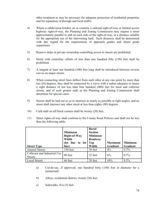
11) Street rights-of-way shall conform to the <strong>County</strong> Road Policies and shall not be less<br />
than the following table:<br />
Rural<br />
Street Type<br />
Minimum<br />
Right-of-Way<br />
Width<br />
(lot line to lot<br />
line)<br />
Section<br />
Minimum<br />
Roadway<br />
Top<br />
Width<br />
Maximum<br />
Gradient<br />
Minimum<br />
Gradient<br />
Arterial Streets 150 feet 36 feet 4% 0.7%<br />
Collector and Industrial Use<br />
Streets<br />
80 feet 32 feet 6% 0.7%<br />
Local Streets 66 feet 28 feet 10% 0.5%<br />
a) Cul-de-sac, if approved, one hundred forty (140) feet in diameter for a<br />
turnaround.<br />
b) Alleys, residential district, twenty (20) feet.<br />
c) Sidewalks, five (5) feet.<br />
78