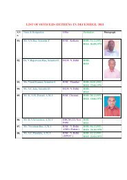
Doppler Weather Radar - METNET - India Meteorological Department
Doppler Weather Radar - METNET - India Meteorological Department
Doppler Weather Radar - METNET - India Meteorological Department

Create successful ePaper yourself
Turn your PDF publications into a flip-book with our unique Google optimized e-Paper software.
Thus now the tasks are configured and scheduled. Any time a scheduled task can be<br />
stopped by right clicking over command area and selecting Stop. Actual scan<br />
strategies followed at DWR PALAM can be seen in D.2.4.5 of APPENDIX D.<br />
1.9.1. Checking whether new scan strategy is working<br />
The newly scheduled scan strategy can be checked by a simple command “productx product<br />
name”. This command when applied to a raw/basic/derived product, it will show all details of<br />
that product, e.g., the server from which it is derived, from which task it is generated, what is<br />
THE PRF,FREQ., and wavelength, at that time, melting level height, power, band width, and<br />
noise of the transmitter, Rx bandwidth, Scan type, Scan speed, Height of radar a.m.s.l: F.,<br />
Processing Mode FFT, Thresholds of different parameters, no. of sweeps, each having 360 rays<br />
and no. of bins and Angle list.<br />
Example for new scan strategy :<br />
[operator@DELHI-STANDBY ~]$ productx DLH100819073440.RAWPRTY<br />
------------- Product Summary for DLH100819073440.RAWPRTY -------------<br />
Ingest site name : 'DWRDELHI(PALAM)', Version: 8.12<br />
Ingest hardware name: 'DWRDELHI(PALAM)'<br />
Product site name : 'DLH-STBY-PLM', Version: 8.12<br />
File size: 3735552 bytes (Disk space: 3735552 bytes)<br />
Product type is: Raw Data<br />
PCO name: IMD-B, TCO name: IMD-B<br />
PRF: 600/450Hz, Wavelength: 10.62cm, Nyquist: 47.79m/s(V), 15.93m/s(W)<br />
XMT Polarization: Horizontal, Wind:???<br />
Constant:67.42 dB, I0:-113.20 dBm, Cal Noise:-81.99 dBm, Bandwidth:0 kHz.<br />
ZFlags: SP_T, block_zc, attn_zc, target_zc, dpatten_zc, dpatten_z<br />
VFlags: SP_V, 3lag_w, ship_v, unfold_vc, fall_vc, storm_vc<br />
Heights: <strong>Radar</strong>: 235m, Ground: 216m, Melting: 5400m MSL<br />
Maximum range: 249.8 km<br />
Ingest time: 07:34:40 19 AUG 2010 UTC (0 minutes west) DST:0/0<br />
Volume scan time: 07:34:40 19 AUG 2010 UTC (LT: IST -330 minutes)<br />
Oldest Ing time: 07:34:40 19 AUG 2010 UTC<br />
Product Gen time: 07:41:35 19 AUG 2010 UTC<br />
Input count: 1<br />
Product is not composted.<br />
Full volume scan, Force 8-bit, Selected data recorded<br />
Information from INGEST Header<br />
------------------------------<br />
17