- Page 1 and 2: A vegetation and vertebrate fauna d
- Page 3 and 4: Some of the rare or beautiful succu
- Page 5 and 6: 6.3.3 Field Survey ................
- Page 7 and 8: 12.1 Specific mitigation measures .
- Page 9 and 10: Figure 25. The vegetation sensitivi
- Page 11 and 12: Figure 54. An easterly view from Bo
- Page 13 and 14: EXECUTIVE SUMMARY Vegetation Althou
- Page 15 and 16: designated sensitive areas and excl
- Page 17 and 18: Holdings (SHE, Pty Ltd). The main c
- Page 19 and 20: 2. ASSIGNMENT Eco-Agent Ecological
- Page 21 and 22: 3. RATIONALE It is widely recognise
- Page 23: 4. SCOPE AND OBJECTIVES OF THE STUD
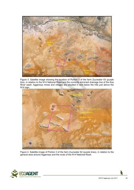
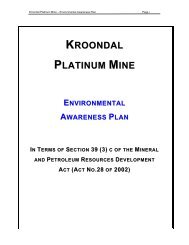
- Page 27 and 28: Topography and drainage The topogra
- Page 29 and 30: Figure 6. Close-up satellite image
- Page 31 and 32: 6. METHODS Prior to the field visit
- Page 33 and 34: 6.1.3 Sensitivity Only High and Low
- Page 35 and 36: • Low probability of occurrence w
- Page 37 and 38: The biodiversity significance of an
- Page 39 and 40: oth by reference to the comprehensi
- Page 41 and 42: 6.4. Herpetofauna 6.4.1. Field Surv
- Page 43 and 44: • Armadillo Girdled Lizard (Cordy
- Page 45 and 46: 7.2 Description of the plant commun
- Page 47 and 48: Figure 12. Stipagrostis namaquensis
- Page 49 and 50: is low, 70-110 mm per annum, mostly
- Page 51 and 52: Figure 14. Grassland on sandy hummo
- Page 53 and 54: This plant community with its speci
- Page 55 and 56: Crassula sericea Dicoma capensis Cu
- Page 57 and 58: Figure 17. A scree slope 4.2.2 Stee
- Page 59 and 60: species also occur on the mountain
- Page 61 and 62: Schmidtia kalahariensis d Stipagros
- Page 63 and 64: 5.2 Washes The drainage lines withi
- Page 65 and 66: in a population going extinct elsew
- Page 67 and 68: 7.4 Fine Scale Biodiversity Fine sc
- Page 69 and 70: The SKEP (2005) biodiversity map fo
- Page 71 and 72: National Herbarium. This is therefo
- Page 73 and 74: Figure 26. A map indicating the Bla
- Page 75 and 76:
7.10 References Acocks, J.P.H. 1988
- Page 78 and 79:
8. RESULTS: MAMMALS Acocks (1988),
- Page 80 and 81:
Figure 27. A south-westerly view ov
- Page 82 and 83:
8.2 Observed and Expected Mammal Sp
- Page 84 and 85:
√ Otocyon megalotis Bat-eared fox
- Page 86 and 87:
8.4 Discussion Four pertinent matte
- Page 88 and 89:
Knobel, J. & Bredenkamp, G. 2005. T
- Page 90 and 91:
9. RESULTS: AVIFAUNA 9.1 General Th
- Page 92 and 93:
Figure 33. View east from the Zuurw
- Page 94 and 95:
Figure 36. View north from the sout
- Page 96 and 97:
Figure 39. View west towards Hoedko
- Page 98 and 99:
Figure 42. Patch of green vegetatio
- Page 100 and 101:
Table 1: Rating of recognised on-si
- Page 102 and 103:
Burchell’s Coucal Centropus burch
- Page 104 and 105:
Karoo Eremomela Eremomela gregalis
- Page 106 and 107:
9.4. Threatened and Red-Listed Bird
- Page 108 and 109:
The remaining four threatened speci
- Page 110 and 111:
Department of Environmental Affairs
- Page 112 and 113:
10. RESULTS: HERPETOFAUNA 10.1. Her
- Page 114 and 115:
Figure 46. A view of red dunes and
- Page 116 and 117:
Figure 50. Man-made quarry on the w
- Page 118 and 119:
In the western corner of the study
- Page 120 and 121:
Very few trees occur on the study s
- Page 122 and 123:
Table 1: Reptile and Amphibian spec
- Page 124 and 125:
? Prosymna bivittata Two-striped Sh
- Page 126 and 127:
Psammophis notostictus Karoo Whip o
- Page 128 and 129:
10.6 Conclusions The main conservat
- Page 130 and 131:
11. ENVIRONMENTAL IMPACT ASSESSMENT
- Page 132 and 133:
assuming that the water does not ha
- Page 134 and 135:
Vegetation Deficient plant -5 Mediu
- Page 136 and 137:
Impact Table 2a:: Impact on biodive
- Page 138 and 139:
Substrate repair 1 2 2 1 2 15 Very
- Page 140 and 141:
maintenance, with designated passin
- Page 142 and 143:
M6: Control of plant diversity/stru
- Page 144 and 145:
Some Red Data plants and animals oc
- Page 146 and 147:
Flora Some areas of infrastructure
- Page 148 and 149:
(increasing or decreasing with time
- Page 150 and 151:
Table 2: Significance Rating Matrix
- Page 152 and 153:
APPENDIX 2: CURRICULII VITAE Abridg
- Page 154 and 155:
- >150 papers at national and inter
- Page 156 and 157:
Visits to Israel, Italy, Germany, U
- Page 158 and 159:
Abridged Curriculum Vitae: Ignatius
- Page 160 and 161:
Abridged Curriculum Vitae: Alan Cha
- Page 162 and 163:
- 15 contributions in or as books
- Page 164 and 165:
Abridged Curriculum Vitae: Jacobus