- Page 2:
Surviving Sudden Environmental Chan
- Page 5 and 6:
© 2012 by the University Press of
- Page 7 and 8:
Contents Chapter 5. Collation, Corr
- Page 9 and 10:
Thomas H. McGovern Maine, on Octobe
- Page 11 and 12:
Thomas H. McGovern as this excellen
- Page 13 and 14:
Thomas H. McGovern McGovern, Thomas
- Page 15 and 16:
Chapter Abstracts eruptions, earthq
- Page 17 and 18:
Chapter Abstracts this is so becaus
- Page 19 and 20:
Chapter Abstracts and concomitant f
- Page 21 and 22: Chapter Abstracts Chapter 8 Long-Te
- Page 24: Surviving Sudden Environmental Chan
- Page 27 and 28: Payson Sheets and Jago Cooper The m
- Page 29 and 30: Payson Sheets and Jago Cooper techn
- Page 31 and 32: Payson Sheets and Jago Cooper The b
- Page 33 and 34: Payson Sheets and Jago Cooper or mi
- Page 35 and 36: Payson Sheets and Jago Cooper tial
- Page 37 and 38: Payson Sheets and Jago Cooper to co
- Page 39 and 40: Payson Sheets and Jago Cooper first
- Page 41 and 42: Payson Sheets and Jago Cooper and-c
- Page 43 and 44: Payson Sheets and Jago Cooper Burto
- Page 45 and 46: Ben Fitzhugh enhanced support for r
- Page 47 and 48: Ben Fitzhugh islands, which are als
- Page 49 and 50: Ben Fitzhugh and millet farming sub
- Page 51 and 52: Ben Fitzhugh 1.2. Eruption of Saryc
- Page 53 and 54: Ben Fitzhugh a greater proportion o
- Page 55 and 56: Ben Fitzhugh but reoccupation proce
- Page 57 and 58: Ben Fitzhugh Large storms pass thro
- Page 59 and 60: Ben Fitzhugh densely populated regi
- Page 61 and 62: Ben Fitzhugh of sustainable settlem
- Page 63 and 64: Ben Fitzhugh Blaikie, P., T. Cannon
- Page 65 and 66: Ben Fitzhugh Marquardt, W. H. 1988
- Page 67 and 68: Ben Fitzhugh Understanding Hazards,
- Page 69 and 70: Payson Sheets a society, or which c
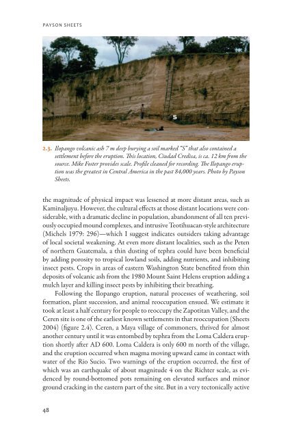
- Page 71: Payson Sheets 2.1. Map of Mexico an
- Page 75 and 76: Payson Sheets area such as El Salva
- Page 77 and 78: Payson Sheets The Barriles society
- Page 79 and 80: Payson Sheets 2.7. Cuicuilco, highl
- Page 81 and 82: Payson Sheets communities around th
- Page 83 and 84: Payson Sheets heading out to sea af
- Page 85 and 86: Payson Sheets successful mitigation
- Page 87 and 88: Payson Sheets Michels, Joe 1979 A H
- Page 89 and 90: Payson Sheets Understanding Hazards
- Page 92 and 93: three Black Sun, High Flame, and Fl
- Page 94 and 95: Black Sun, High Flame, and Flood th
- Page 96 and 97: Black Sun, High Flame, and Flood fa
- Page 98 and 99: Black Sun, High Flame, and Flood Bo
- Page 100 and 101: Black Sun, High Flame, and Flood et
- Page 102 and 103: Black Sun, High Flame, and Flood Te
- Page 104 and 105: Black Sun, High Flame, and Flood In
- Page 106 and 107: Black Sun, High Flame, and Flood Th
- Page 108 and 109: Black Sun, High Flame, and Flood 3.
- Page 110 and 111: Black Sun, High Flame, and Flood Ac
- Page 112 and 113: Black Sun, High Flame, and Flood Ha
- Page 114: Black Sun, High Flame, and Flood Un
- Page 117 and 118: Jago Cooper The absence of other ca
- Page 119 and 120: Jago Cooper causality and the relat
- Page 121 and 122: Jago Cooper scale case studies to c
- Page 123 and 124:
Jago Cooper the Caribbean lacks the
- Page 125 and 126:
Jago Cooper record of hurricane lan
- Page 127 and 128:
Jago Cooper but at this stage the f
- Page 129 and 130:
Jago Cooper paleoenvironmental sett
- Page 131 and 132:
Jago Cooper Summary and Future Rese
- Page 133 and 134:
Jago Cooper Beck, Warren J., Jacque
- Page 135 and 136:
Jago Cooper Goudie, Andrew 2006 The
- Page 137 and 138:
Jago Cooper Redman, Charles L., and
- Page 139 and 140:
Jago Cooper Understanding Hazards,
- Page 142 and 143:
Five Collation, Correlation, and Ca
- Page 144 and 145:
Collation, Correlation, and Causati
- Page 146 and 147:
Collation, Correlation, and Causati
- Page 148 and 149:
Collation, Correlation, and Causati
- Page 150 and 151:
Collation, Correlation, and Causati
- Page 152 and 153:
Collation, Correlation, and Causati
- Page 154 and 155:
Collation, Correlation, and Causati
- Page 156 and 157:
Collation, Correlation, and Causati
- Page 158 and 159:
Collation, Correlation, and Causati
- Page 160 and 161:
Collation, Correlation, and Causati
- Page 162 and 163:
Collation, Correlation, and Causati
- Page 164 and 165:
Collation, Correlation, and Causati
- Page 166:
Collation, Correlation, and Causati
- Page 169 and 170:
Emily McClung de Tapia 6.1. Prehisp
- Page 171 and 172:
Emily McClung de Tapia 6.2. Locatio
- Page 173 and 174:
Emily McClung de Tapia the importan
- Page 175 and 176:
Emily McClung de Tapia remains, sug
- Page 177 and 178:
Emily McClung de Tapia 6.3. Erosion
- Page 179 and 180:
Emily McClung de Tapia construction
- Page 181 and 182:
Emily McClung de Tapia indigenous p
- Page 183 and 184:
6.4. Flooding of the major highway
- Page 185 and 186:
Emily McClung de Tapia D. Qin, M. M
- Page 187 and 188:
Emily McClung de Tapia Lounejeva-Ba
- Page 189 and 190:
Emily McClung de Tapia Rivera-Uria,
- Page 192 and 193:
Seven Domination and Resilience in
- Page 194 and 195:
Domination and Resilience in Bronze
- Page 196 and 197:
Domination and Resilience in Bronze
- Page 198 and 199:
Domination and Resilience in Bronze
- Page 200 and 201:
Domination and Resilience in Bronze
- Page 202 and 203:
Domination and Resilience in Bronze
- Page 204 and 205:
Domination and Resilience in Bronze
- Page 206 and 207:
Domination and Resilience in Bronze
- Page 208 and 209:
Domination and Resilience in Bronze
- Page 210 and 211:
Domination and Resilience in Bronze
- Page 212 and 213:
Domination and Resilience in Bronze
- Page 214 and 215:
Domination and Resilience in Bronze
- Page 216 and 217:
Domination and Resilience in Bronze
- Page 218 and 219:
Domination and Resilience in Bronze
- Page 220:
Domination and Resilience in Bronze
- Page 223 and 224:
Nelson et al. Mexico (figure 8.1) t
- Page 225 and 226:
Nelson et al. what (Carpenter et al
- Page 227 and 228:
Nelson et al. 8.2. Images that illu
- Page 229 and 230:
Nelson et al. Specifically, we aske
- Page 231 and 232:
Nelson et al. its value in making a
- Page 233 and 234:
Nelson et al. 8.4). However, an ext
- Page 235 and 236:
Nelson et al. floodwater gave way t
- Page 237 and 238:
Nelson et al. 8.6. A Classic Mimbre
- Page 239 and 240:
Nelson et al. 3. Isolation can cont
- Page 241 and 242:
Nelson et al. Folke, Carl 2006 Resi
- Page 243 and 244:
Nelson et al. Tiempos Prehispánico
- Page 245 and 246:
Nelson et al. Turney, Omar 1929 Pre
- Page 248 and 249:
Nine Social Evolution, Hazards, and
- Page 250 and 251:
Social Evolution, Hazards, and Resi
- Page 252 and 253:
Social Evolution, Hazards, and Resi
- Page 254 and 255:
Social Evolution, Hazards, and Resi
- Page 256 and 257:
Social Evolution, Hazards, and Resi
- Page 258 and 259:
Social Evolution, Hazards, and Resi
- Page 260 and 261:
Social Evolution, Hazards, and Resi
- Page 262 and 263:
ten Global Environmental Change, Re
- Page 264 and 265:
Global Environmental Change, Resili
- Page 266 and 267:
Global Environmental Change, Resili
- Page 268 and 269:
Global Environmental Change, Resili
- Page 270 and 271:
Contributors David A. Abbott Arizon
- Page 272:
Contributors Jeffrey Quilter Harvar
- Page 275 and 276:
Index Bárdarbunga volcano, 72 Barr
- Page 277 and 278:
Index Hazards, 3, 6, 42, 92, 106, 2
- Page 279 and 280:
Index Paramushir Island, 25 Pastora
- Page 281:
Index social-ecological structure,