Condit Dam Removal Condit Dam Removal - Access Washington
Condit Dam Removal Condit Dam Removal - Access Washington
Condit Dam Removal Condit Dam Removal - Access Washington

You also want an ePaper? Increase the reach of your titles
YUMPU automatically turns print PDFs into web optimized ePapers that Google loves.
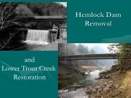
<strong>Condit</strong> <strong>Dam</strong> Hydroelectric Project<br />
Final Supplemental EIS<br />
in Indian Creek above the lower road culvert (Connolly 2005a, 2005b, 2005c). This indicates<br />
that Indian Creek is used by spawning fluvial-adfluvial rainbow and coastal cutthroat trout from<br />
the White Salmon River. Resident trout occur in Indian Creek at least as far upstream as<br />
permission to survey has been granted (1.9 miles). A total of 1.1 miles of Indian Creek was<br />
surveyed by single pass electroshocking methodology in 2001 and 2002 (Allen et al. 2003).<br />
Over 81 percent of the age 1 or older salmonid population collected were coastal cutthroat trout,<br />
with the rest of the salmonids composed of rainbow trout. All but one trout captured in the upper<br />
0.6 miles of surveyed stream were coastal cutthroat trout. The upper 0.6 miles of surveyed<br />
stream was above 2 road culverts that apparently restrict access by spawning rainbow trout from<br />
Rattlesnake Creek and the White Salmon River to the upper reaches of Indian Creek. The only<br />
other fish documented in Indian Creek were shorthead sculpin, which occurred throughout the<br />
surveyed reaches. The average gradient of Indian Creek varied from 2.8 percent in the lower<br />
surveyed reach to 4.7 percent in the upper surveyed reach and the maximum temperature<br />
measured during the summer was 71.2ºF. During a survey of the lower 0.5 mile of Indian Creek<br />
in August, rainbow trout had a maximum of 6 inches FL and coastal cutthroat trout had a<br />
maximum of 8 inches FL. The majority of rainbow collected were age 0 fish, while the majority<br />
of coastal cutthroat collected were age 1 or older fish.<br />
Mill Creek is a tributary of Rattlesnake Creek entering at RM 8.7. It was surveyed from its<br />
mouth to 0.6 mile upstream and for 196 yards starting at a point 1.6 miles upstream (Allen et al.<br />
2003). It contained resident rainbow trout and shorthead sculpin in the lower surveyed reach and<br />
only rainbow trout in the upper surveyed reach. The average gradient of Mill Creek was 8.1<br />
percent and the maximum water temperature measured during the summer was 60.3ºF. During a<br />
survey in October, resident rainbow trout up to 7.3 inches FL were collected in the lower 0.6<br />
mile of Mill Creek. The majority of trout collected were age 1 or older fish.<br />
Spring Creek (RM 6.6)<br />
A private hydro dam at RM 0.7 is a complete barrier to fish passage (Chapman et al. 1990).<br />
Coastal cutthroat have been documented in Spring Creek above the dam (Rawding 2005, Blakley<br />
et al. 2000). Resident rainbow trout were documented below the dam during snorkel surveys on<br />
August 13, 2001 (Thiesfeld et al. 2001). Water temperature during the surveys was recorded as<br />
53ºF and the average gradient was 1.2 percent. Spring Creek had a rainbow trout density of<br />
13.79 fish per 100 yards 2 . A few brook trout (1.11 fish per 100 yards 2 ) and sculpin (Cottus sp.)<br />
were seen during night snorkeling.<br />
Buck Creek (RM 5.0)<br />
A diversion dam at RM 1.9 (Chapman et al. 1990) is a partial barrier to fish passage. U.S. Forest<br />
Service biologists observed fish attempting to jump over this structure and noted that trout over<br />
approximately 9 inches in length were able to pass over the structure (Bair et al. 2002). The<br />
diversion dam located at RM 3.8 and the 12- to 14-foot water fall located at RM 3.2 are complete<br />
barriers to the passage of anadromous fish (Chapman et al. 1990, Thiesfeld et al. 2001). Also,<br />
the 20-foot falls located at RM 4.0 is a barrier.<br />
Snorkel surveys were conducted on June 26, 2001 at RM 1.4, above the diversion dam at RM<br />
3.9, and in the Middle Fork at RM 0.1 (which enters Buck Creek at RM 4.9). Water<br />
C-4