4.7 Getting started - WindSim
4.7 Getting started - WindSim
4.7 Getting started - WindSim

You also want an ePaper? Increase the reach of your titles
YUMPU automatically turns print PDFs into web optimized ePapers that Google loves.
Terrain<br />
13<br />
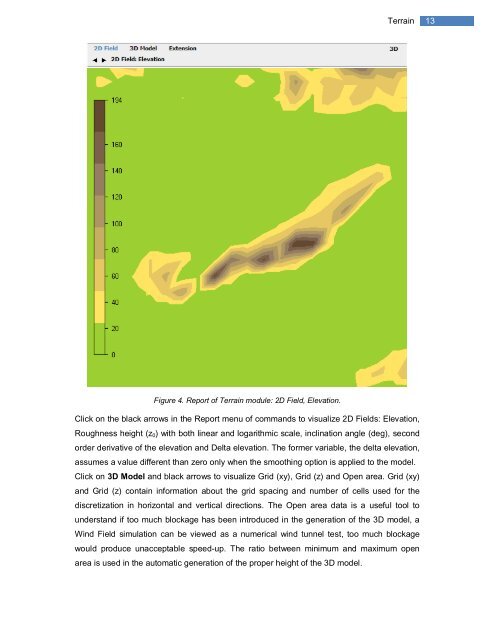
Figure 4. Report of Terrain module: 2D Field, Elevation.<br />
Click on the black arrows in the Report menu of commands to visualize 2D Fields: Elevation,<br />
Roughness height (z 0 ) with both linear and logarithmic scale, inclination angle (deg), second<br />
order derivative of the elevation and Delta elevation. The former variable, the delta elevation,<br />
assumes a value different than zero only when the smoothing option is applied to the model.<br />
Click on 3D Model and black arrows to visualize Grid (xy), Grid (z) and Open area. Grid (xy)<br />
and Grid (z) contain information about the grid spacing and number of cells used for the<br />
discretization in horizontal and vertical directions. The Open area data is a useful tool to<br />
understand if too much blockage has been introduced in the generation of the 3D model, a<br />
Wind Field simulation can be viewed as a numerical wind tunnel test, too much blockage<br />
would produce unacceptable speed-up. The ratio between minimum and maximum open<br />
area is used in the automatic generation of the proper height of the 3D model.