General Plan Policy Document (Adopted 7-11 ... - City of Wheatland
General Plan Policy Document (Adopted 7-11 ... - City of Wheatland
General Plan Policy Document (Adopted 7-11 ... - City of Wheatland

Create successful ePaper yourself
Turn your PDF publications into a flip-book with our unique Google optimized e-Paper software.
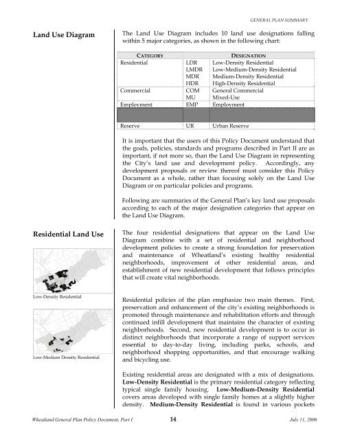
GENERAL PLAN SUMMARYLandUseDiagramThe Land Use Diagram includes 10 land use designations fallingwithin 5 major categories, as shown in the following chart:ResidentialCATEGORYCommercialLDRLMDRMDRHDRCOMMUDESIGNATIONLow-Density ResidentialLow-Medium-Density ResidentialMedium-Density ResidentialHigh-Density Residential<strong>General</strong> CommercialMixed-UseEmployment EMP EmploymentPublic and Open Space PUBLICPARKPublicPark and Open SpaceReserve UR Urban ReserveIt is important that the users <strong>of</strong> this <strong>Policy</strong> <strong>Document</strong> understand thatthe goals, policies, standards and programs described in Part II are asimportant, if not more so, than the Land Use Diagram in representingthe <strong>City</strong>’s land use and development policy. Accordingly, anydevelopment proposals or review there<strong>of</strong> must consider this <strong>Policy</strong><strong>Document</strong> as a whole, rather than focusing solely on the Land UseDiagram or on particular policies and programs.ResidentialLandUseLowDensityResidentialLowMediumDensityResidentialFollowing are summaries <strong>of</strong> the <strong>General</strong> <strong>Plan</strong>’s key land use proposalsaccording to each <strong>of</strong> the major designation categories that appear onthe Land Use Diagram.The four residential designations that appear on the Land UseDiagram combine with a set <strong>of</strong> residential and neighborhooddevelopment policies to create a strong foundation for preservationand maintenance <strong>of</strong> <strong>Wheatland</strong>’s existing healthy residentialneighborhoods, improvement <strong>of</strong> other residential areas, andestablishment <strong>of</strong> new residential development that follows principlesthat will create vital neighborhoods.Residential policies <strong>of</strong> the plan emphasize two main themes. First,preservation and enhancement <strong>of</strong> the city’s existing neighborhoods ispromoted through maintenance and rehabilitation efforts and throughcontinued infill development that maintains the character <strong>of</strong> existingneighborhoods. Second, new residential development is to occur indistinct neighborhoods that incorporate a range <strong>of</strong> support servicesessential to day-to-day living, including parks, schools, andneighborhood shopping opportunities, and that encourage walkingand bicycling use.Existing residential areas are designated with a mix <strong>of</strong> designations.Low-Density Residential is the primary residential category reflectingtypical single family housing. Low-Medium-Density Residentialcovers areas developed with single family homes at a slightly higherdensity. Medium-Density Residential is found in various pockets<strong>Wheatland</strong> <strong>General</strong> <strong>Plan</strong> <strong>Policy</strong> <strong>Document</strong>, Part I 14July <strong>11</strong>, 2006

![[Read-Only].pdf - City of Wheatland - State of California](https://img.yumpu.com/37333564/1/190x146/read-onlypdf-city-of-wheatland-state-of-california.jpg?quality=85)