General Plan Policy Document (Adopted 7-11 ... - City of Wheatland
General Plan Policy Document (Adopted 7-11 ... - City of Wheatland
General Plan Policy Document (Adopted 7-11 ... - City of Wheatland

Create successful ePaper yourself
Turn your PDF publications into a flip-book with our unique Google optimized e-Paper software.
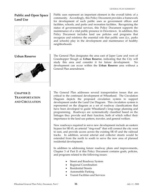
GENERAL PLAN SUMMARYPublicandOpenSpaceLandUseUrbanReservePublic uses represent an important element in the overall fabric <strong>of</strong> acommunity. Accordingly, this <strong>Policy</strong> <strong>Document</strong> provides a frameworkfor development <strong>of</strong> such public uses as government <strong>of</strong>fices andfacilities, schools, and parks and recreation facilities. Recognizing thestatus <strong>of</strong> governmental services, this <strong>Policy</strong> <strong>Document</strong> supports themaintenance <strong>of</strong> a vital public presence in Downtown. In addition, this<strong>Policy</strong> <strong>Document</strong> includes land use policies and programs thatrecognize and reinforce the essential role that public uses (i.e., parksand schools) play in the development and maintenance <strong>of</strong> healthyneighborhoods.The <strong>General</strong> <strong>Plan</strong> designates the area east <strong>of</strong> Japer Lane and west <strong>of</strong>Grasshopper Slough as Urban Reserve, indicating that the <strong>City</strong> willstudy this area and consider it for future development. Nodevelopment can occur within the Urban Reserve area without a<strong>General</strong> <strong>Plan</strong> amendment.CHAPTER2:TRANSPORTATIONANDCIRCULATIONThe <strong>General</strong> <strong>Plan</strong> addresses several transportation issues that arecritical to the continued development <strong>of</strong> <strong>Wheatland</strong>. The CirculationDiagram depicts the proposed circulation system to supportdevelopment under the Land Use Diagram. This circulation system isrepresented on the diagram as a set <strong>of</strong> roadway classifications thathave been developed to guide <strong>Wheatland</strong>’s long-range planning andprogramming. Roadways are systematically classified based on thelinkages they provide and their function, both <strong>of</strong> which reflect theirimportance to the land use pattern, traveler, and general welfare.New roadways required to serve new development include an easternbypass for SR 65, an arterial “ring-road” that will connect the city westto east, and provide access across the existing SR 65 and the railroadtracks. In addition, several arterial and collector streets would beextended from the north to south to serve the new area <strong>of</strong> plannedresidential development.In addition to addressing future roadway plans and improvements,Chapter 3 <strong>of</strong> Part II <strong>of</strong> this <strong>Policy</strong> <strong>Document</strong> contains goals, policies,and programs related to the following issues: Street and Roadway System Regional Coordination Residential Streets Automobile Parking Transit Facilities and Services<strong>Wheatland</strong> <strong>General</strong> <strong>Plan</strong> <strong>Policy</strong> <strong>Document</strong>, Part I 16July <strong>11</strong>, 2006

![[Read-Only].pdf - City of Wheatland - State of California](https://img.yumpu.com/37333564/1/190x146/read-onlypdf-city-of-wheatland-state-of-california.jpg?quality=85)