Warrawee Substation - Review of Environmental Factors
Warrawee Substation - Review of Environmental Factors
Warrawee Substation - Review of Environmental Factors
- No tags were found...

Create successful ePaper yourself
Turn your PDF publications into a flip-book with our unique Google optimized e-Paper software.
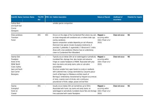
Scientific Name Common NameTSC/FMActEPBC Act Habitat Association Nature <strong>of</strong> Record Likelihood <strong>of</strong>occurrencePotential for impactsSydney Basinand South EastCornerbioregionsvariable species composition.Shale-sandstoneTransitionForestEEC EEC Occurs on the edges <strong>of</strong> the Cumberland Plain where clay soilson shale intergrade with sandstone soils, or where shale capsoverlay sandstone.Species composition variable depending on soil influences.Dominant tree species include Eucalyptus tereticornis, E.punctata, E. globoidea, E. eugenioides, E. fibrosa and E. crebra.Areas with a low sandstone influence have an understoreycloser to Cumberland Plain Woodland.Mapped asoccurring within10km (Tozer et al2010)Does not occur.Nil.Swamp OakFloodplainforest <strong>of</strong> theNSW NorthCoast, Sydneybasin and SouthEast CornerBioregionsEEC - Typically occurs below 20m asl on waterlogged or periodicallyinundated flats, drainage lines, lake margins and estuarinefringes on coastal floodplains <strong>of</strong> NSW. Associated with greyblackclay-loams and sandy loams, saline or sub-salinegroundwater.Structure variable from open forests to scrubs or reedlandswith scattered trees. Canopy dominated by Casuarina glauca(north <strong>of</strong> Bermagui) or Melaleuca ericifolia (south <strong>of</strong>Bermagui). Understorey characterised by frequent occurrences<strong>of</strong> vines, a sparse cover <strong>of</strong> shrubs, and a continuousgroundcover <strong>of</strong> forbs, sedges, grasses and leaf litter.Mapped asoccurring within10km (Tozer et al2010)Does not occur.Nil.SwampSclerophyllforest onCoastalEEC - Usually occurs below 20m asl (sometimes up to 50m).Associated with humic clay loams and sandy loams, onwaterlogged or periodically inundated alluvial flats and drainagelines associated with coastal floodplains.Mapped asoccurring within10km (Tozer et al2010)Does not occur.Nil.