

Landslides in the Sydney Basin - Geoscience Australia
Landslides in the Sydney Basin - Geoscience Australia
Landslides in the Sydney Basin - Geoscience Australia
- No tags were found...

You also want an ePaper? Increase the reach of your titles
YUMPU automatically turns print PDFs into web optimized ePapers that Google loves.
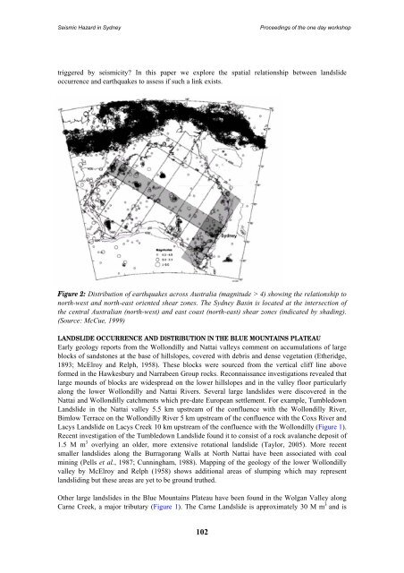
Seismic Hazard <strong>in</strong> <strong>Sydney</strong>Proceed<strong>in</strong>gs of <strong>the</strong> one day workshoptriggered by seismicity? In this paper we explore <strong>the</strong> spatial relationship between landslideoccurrence and earthquakes to assess if such a l<strong>in</strong>k exists.Figure 2: Distribution of earthquakes across <strong>Australia</strong> (magnitude > 4) show<strong>in</strong>g <strong>the</strong> relationship tonorth-west and north-east oriented shear zones. The <strong>Sydney</strong> Bas<strong>in</strong> is located at <strong>the</strong> <strong>in</strong>tersection of<strong>the</strong> central <strong>Australia</strong>n (north-west) and east coast (north-east) shear zones (<strong>in</strong>dicated by shad<strong>in</strong>g).(Source: McCue, 1999)LANDSLIDE OCCURRENCE AND DISTRIBUTION IN THE BLUE MOUNTAINS PLATEAUEarly geology reports from <strong>the</strong> Wollondilly and Nattai valleys comment on accumulations of largeblocks of sandstones at <strong>the</strong> base of hillslopes, covered with debris and dense vegetation (E<strong>the</strong>ridge,1893; McElroy and Relph, 1958). These blocks were sourced from <strong>the</strong> vertical cliff l<strong>in</strong>e aboveformed <strong>in</strong> <strong>the</strong> Hawkesbury and Narrabeen Group rocks. Reconnaissance <strong>in</strong>vestigations revealed thatlarge mounds of blocks are widespread on <strong>the</strong> lower hillslopes and <strong>in</strong> <strong>the</strong> valley floor particularlyalong <strong>the</strong> lower Wollondilly and Nattai Rivers. Several large landslides were discovered <strong>in</strong> <strong>the</strong>Nattai and Wollondilly catchments which pre-date European settlement. For example, TumbledownLandslide <strong>in</strong> <strong>the</strong> Nattai valley 5.5 km upstream of <strong>the</strong> confluence with <strong>the</strong> Wollondilly River,Bimlow Terrace on <strong>the</strong> Wollondilly River 5 km upstream of <strong>the</strong> confluence with <strong>the</strong> Coxs River andLacys Landslide on Lacys Creek 10 km upstream of <strong>the</strong> confluence with <strong>the</strong> Wollondilly (Figure 1).Recent <strong>in</strong>vestigation of <strong>the</strong> Tumbledown Landslide found it to consist of a rock avalanche deposit of1.5 M m 3 overly<strong>in</strong>g an older, more extensive rotational landslide (Taylor, 2005). More recentsmaller landslides along <strong>the</strong> Burragorang Walls at North Nattai have been associated with coalm<strong>in</strong><strong>in</strong>g (Pells et al., 1987; Cunn<strong>in</strong>gham, 1988). Mapp<strong>in</strong>g of <strong>the</strong> geology of <strong>the</strong> lower Wollondillyvalley by McElroy and Relph (1958) shows additional areas of slump<strong>in</strong>g which may representlandslid<strong>in</strong>g but <strong>the</strong>se areas are yet to be ground tru<strong>the</strong>d.O<strong>the</strong>r large landslides <strong>in</strong> <strong>the</strong> Blue Mounta<strong>in</strong>s Plateau have been found <strong>in</strong> <strong>the</strong> Wolgan Valley alongCarne Creek, a major tributary (Figure 1). The Carne Landslide is approximately 30 M m 3 and is102


