

Landslides in the Sydney Basin - Geoscience Australia
Landslides in the Sydney Basin - Geoscience Australia
Landslides in the Sydney Basin - Geoscience Australia
- No tags were found...

You also want an ePaper? Increase the reach of your titles
YUMPU automatically turns print PDFs into web optimized ePapers that Google loves.
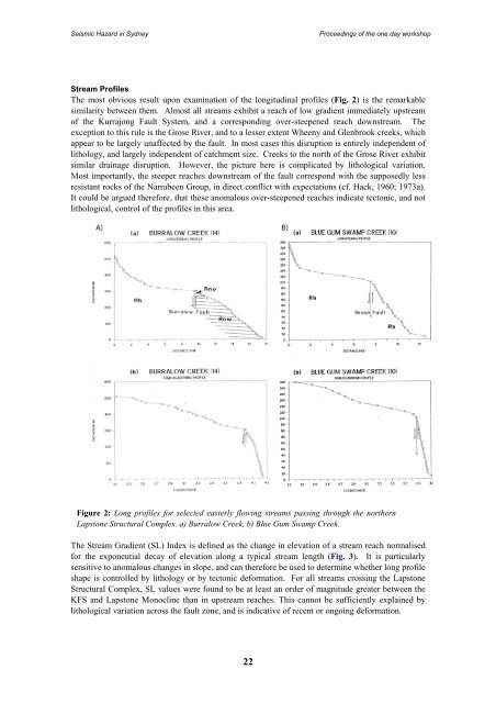
Seismic Hazard <strong>in</strong> <strong>Sydney</strong>Proceed<strong>in</strong>gs of <strong>the</strong> one day workshopStream ProfilesThe most obvious result upon exam<strong>in</strong>ation of <strong>the</strong> longitud<strong>in</strong>al profiles (Fig. 2) is <strong>the</strong> remarkablesimilarity between <strong>the</strong>m. Almost all streams exhibit a reach of low gradient immediately upstreamof <strong>the</strong> Kurrajong Fault System, and a correspond<strong>in</strong>g over-steepened reach downstream. Theexception to this rule is <strong>the</strong> Grose River, and to a lesser extent Wheeny and Glenbrook creeks, whichappear to be largely unaffected by <strong>the</strong> fault. In most cases this disruption is entirely <strong>in</strong>dependent oflithology, and largely <strong>in</strong>dependent of catchment size. Creeks to <strong>the</strong> north of <strong>the</strong> Grose River exhibitsimilar dra<strong>in</strong>age disruption. However, <strong>the</strong> picture here is complicated by lithological variation.Most importantly, <strong>the</strong> steeper reaches downstream of <strong>the</strong> fault correspond with <strong>the</strong> supposedly lessresistant rocks of <strong>the</strong> Narrabeen Group, <strong>in</strong> direct conflict with expectations (cf. Hack, 1960; 1973a).It could be argued <strong>the</strong>refore, that <strong>the</strong>se anomalous over-steepened reaches <strong>in</strong>dicate tectonic, and notlithological, control of <strong>the</strong> profiles <strong>in</strong> this area.Figure 2: Long profiles for selected easterly flow<strong>in</strong>g streams pass<strong>in</strong>g through <strong>the</strong> nor<strong>the</strong>rnLapstone Structural Complex. a) Burralow Creek, b) Blue Gum Swamp Creek.The Stream Gradient (SL) Index is def<strong>in</strong>ed as <strong>the</strong> change <strong>in</strong> elevation of a stream reach normalisedfor <strong>the</strong> exponential decay of elevation along a typical stream length (Fig. 3). It is particularlysensitive to anomalous changes <strong>in</strong> slope, and can <strong>the</strong>refore be used to determ<strong>in</strong>e whe<strong>the</strong>r long profileshape is controlled by lithology or by tectonic deformation. For all streams cross<strong>in</strong>g <strong>the</strong> LapstoneStructural Complex, SL values were found to be at least an order of magnitude greater between <strong>the</strong>KFS and Lapstone Monocl<strong>in</strong>e than <strong>in</strong> upstream reaches. This cannot be sufficiently expla<strong>in</strong>ed bylithological variation across <strong>the</strong> fault zone, and is <strong>in</strong>dicative of recent or ongo<strong>in</strong>g deformation.22


