

Landslides in the Sydney Basin - Geoscience Australia
Landslides in the Sydney Basin - Geoscience Australia
Landslides in the Sydney Basin - Geoscience Australia
- No tags were found...

You also want an ePaper? Increase the reach of your titles
YUMPU automatically turns print PDFs into web optimized ePapers that Google loves.
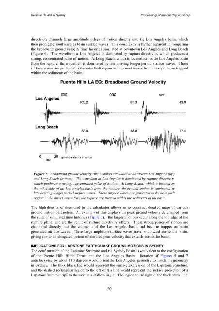
Seismic Hazard <strong>in</strong> <strong>Sydney</strong>Proceed<strong>in</strong>gs of <strong>the</strong> one day workshopdirectivity channels large amplitude pulses of motion directly <strong>in</strong>to <strong>the</strong> Los Angeles bas<strong>in</strong>, which<strong>the</strong>n propagate southward as bas<strong>in</strong> surface waves. This complexity is fur<strong>the</strong>r apparent <strong>in</strong> compar<strong>in</strong>g<strong>the</strong> broadband ground velocity time histories simulated at downtown Los Angeles and Long Beach(Figure 6). The waveform at Los Angeles is dom<strong>in</strong>ated by rupture directivity, which produces astrong, concentrated pulse of motion. At Long Beach, which is located across <strong>the</strong> Los Angeles bas<strong>in</strong>from <strong>the</strong> rupture, <strong>the</strong> waveform is dom<strong>in</strong>ated by late arriv<strong>in</strong>g longer period surface waves. Thesesurface waves are generated <strong>in</strong> <strong>the</strong> near fault region as <strong>the</strong> direct waves from <strong>the</strong> rupture are trappedwith<strong>in</strong> <strong>the</strong> sediments of <strong>the</strong> bas<strong>in</strong>.Figure 6: Broadband ground velocity time histories simulated at downtown Los Angeles (top)and Long Beach (bottom). The waveform at Los Angeles is dom<strong>in</strong>ated by rupture directivity,which produces a strong, concentrated pulse of motion. At Long Beach, which is located on<strong>the</strong> o<strong>the</strong>r side of <strong>the</strong> Los Angeles bas<strong>in</strong> from <strong>the</strong> rupture, <strong>the</strong> ground motion is dom<strong>in</strong>ated bylate arriv<strong>in</strong>g longer period surface waves. These surface waves are generated <strong>in</strong> <strong>the</strong> near faultregion as <strong>the</strong> direct waves from <strong>the</strong> rupture are trapped with<strong>in</strong> <strong>the</strong> sediments of <strong>the</strong> bas<strong>in</strong>.The high density of sites used <strong>in</strong> <strong>the</strong> calculation allows us to construct detailed maps of variousground motion parameters. An example of this displays <strong>the</strong> peak ground velocity determ<strong>in</strong>ed from<strong>the</strong> suite of simulated time histories (Figure 7). The largest motions occur along <strong>the</strong> top edge of <strong>the</strong>rupture plane, and are <strong>the</strong> result of rupture directivity effects. These strong pulses of motion arechanneled directly <strong>in</strong>to <strong>the</strong> sediments of <strong>the</strong> Los Angeles bas<strong>in</strong> and become trapped as bas<strong>in</strong>generated surface waves. These large amplitude surface waves travel southward across <strong>the</strong> bas<strong>in</strong>,giv<strong>in</strong>g rise to an elongated pattern of elevated peak velocity that extends across <strong>the</strong> bas<strong>in</strong>.IMPLICATIONS FOR LAPSTONE EARTHQUAKE GROUND MOTIONS IN SYDNEYThe configuration of <strong>the</strong> Lapstone Structure and <strong>the</strong> <strong>Sydney</strong> Bas<strong>in</strong> is equivalent to <strong>the</strong> configurationof <strong>the</strong> Puente Hills Bl<strong>in</strong>d Thrust and <strong>the</strong> Los Angeles Bas<strong>in</strong>. Rotation of Figures 5 and 7anticlockwise by about 110 degrees would orient <strong>the</strong> Los Angeles geometry to match <strong>the</strong> geometry<strong>in</strong> <strong>Sydney</strong>. The thick black l<strong>in</strong>e would represent <strong>the</strong> surface expression of <strong>the</strong> Lapstone Structure,and <strong>the</strong> dashed rectangular region to <strong>the</strong> left of this l<strong>in</strong>e would represent <strong>the</strong> surface projection of aLapstone fault that dips to <strong>the</strong> west at a shallow angle. The region to <strong>the</strong> right of <strong>the</strong> thick black l<strong>in</strong>e90


