Seismic Hazard <strong>in</strong> <strong>Sydney</strong>Proceed<strong>in</strong>gs of <strong>the</strong> one day workshopa magnitude estimate of about ML 4.6. It was felt with Modified Mercalli <strong>in</strong>tensity 5 at Kurrajong,on <strong>the</strong> Nepean River about 50 km north-west of <strong>Sydney</strong>. Highest <strong>in</strong>tensities were reported fromnorth and west of Kurrajong. The <strong>in</strong>tensity <strong>in</strong> <strong>Sydney</strong> was about MM 3. It was felt by a few peopleat rest <strong>in</strong>doors <strong>in</strong> Newcastle. It was crudely located us<strong>in</strong>g <strong>in</strong>tensity data near <strong>the</strong> north end of <strong>the</strong>Lapstone Fault, and may have been on ei<strong>the</strong>r that fault or a related fault.1961 May 21, Robertson, ML 5.5: An earthquake of magnitude ML 5.5 occurred near Robertson on1961 May 22 at 0740 am AEST. This is about 60 kilometres south-west of <strong>Sydney</strong>. It has also beencalled <strong>the</strong> Bowral earthquake. The maximum <strong>in</strong>tensities <strong>in</strong> <strong>the</strong> Robertson-Bowral area were aboutMM 7. The earthquake caused significant damage to build<strong>in</strong>gs <strong>in</strong> <strong>the</strong> Moss Vale, Robertson andBowral area, blocked <strong>the</strong> Macquarie Pass road with rockfalls, and caused some power failures. The<strong>in</strong>tensity <strong>in</strong> <strong>Sydney</strong> was about MM 3. The epicentre was with<strong>in</strong> a few kilometres of <strong>the</strong> presentlocation of W<strong>in</strong>gecarribee Dam which was completed <strong>in</strong> 1974.1973 March 9, Burragorang, ML 5.5: An earthquake of magnitude ML 5.5 occurred near <strong>the</strong>sou<strong>the</strong>rn end of Lake Burragorang, about 30 km west of Picton on 1973 March 10 at 0509 am,AEST. This is about 70 kilometres WSW of <strong>Sydney</strong>. It has also been called <strong>the</strong> Picton earthquake. Itcaused about $A500,000 (1973 values) damage. It has been suggested that <strong>the</strong> earthquake couldhave been reservoir <strong>in</strong>duced, but it is difficult to prove this (Drake, 1974). If this was <strong>the</strong> case, it isan example of delayed reservoir <strong>in</strong>duced seismicity. The earthquake was probably at a dep<strong>the</strong>xceed<strong>in</strong>g 12 km, and occurred about 12 years after reservoir fill<strong>in</strong>g commenced.1981 November 15, App<strong>in</strong>, ML 4.6: An earthquake of magnitude ML 4.6 occurred near App<strong>in</strong> on1981 November 16 at 0358 am, AEST. This is about 50 kilometres south-west of <strong>Sydney</strong>. Intensitiesof MM 4 were felt over a broad area south-west of <strong>Sydney</strong>, but with only isolated values of MM 5 <strong>in</strong><strong>the</strong> epicentral area. No damage was reported.1985 February 13, Lithgow, ML 4.3: An earthquake of magnitude ML 4.3 occurred near Lithgow on1985 February 13 at 0701 pm AEDT (daylight sav<strong>in</strong>g time). This is about 100 kilometres west of<strong>Sydney</strong>. Intensities of up to MM 7 were reported <strong>in</strong> <strong>the</strong> epicentral area, with m<strong>in</strong>or damage toplaster, brickwork, tiles and chimneys, <strong>in</strong>clud<strong>in</strong>g several partly demolished chimneys. Objects felloff shelves <strong>in</strong> many parts of Lithgow. Total damage was estimated at A$65,000 (1985). The<strong>in</strong>tensity <strong>in</strong> <strong>Sydney</strong> was very low, with only a few people report<strong>in</strong>g MM 2 to 3. The earthquake wasfelt much fur<strong>the</strong>r to <strong>the</strong> west than to <strong>the</strong> east, suggest<strong>in</strong>g that it may have been on a west-dipp<strong>in</strong>gfault.1989 December 28, Newcastle, ML 5.6: The earthquake on Thursday 1989 December 28 at 1027 amAEDT was <strong>the</strong> first <strong>Australia</strong>n earthquake confirmed to have caused fatalities. Thirteen people werekilled by <strong>the</strong> earthquake, and <strong>the</strong>re were hundreds of <strong>in</strong>juries. Extensive m<strong>in</strong>or and moderate damagegave a total cost that exceeded A$1,500 million. This earthquake was centred off <strong>the</strong> north-east of<strong>the</strong> map <strong>in</strong> figure 1, and was felt over a radius of about 300 kilometres.1999 March 17, App<strong>in</strong>, ML 4.4: An earthquake of magnitude 4.4 occurred near App<strong>in</strong> onWednesday 1999 March 17 at 12:58 pm AEDT. The maximum reported <strong>in</strong>tensity was of MM 5,although <strong>the</strong>re were some reports of m<strong>in</strong>or damage <strong>in</strong> <strong>the</strong> epicentral area. It caused some powerfailures, and was felt throughout <strong>the</strong> <strong>Sydney</strong> area.49
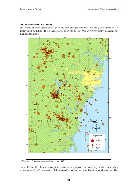
Seismic Hazard <strong>in</strong> <strong>Sydney</strong>Proceed<strong>in</strong>gs of <strong>the</strong> one day workshopPre- and Post-1992 SeismicityThe quality of seismograph coverage of any area changes with time, and <strong>the</strong> general trend is forimprovement with time. In <strong>the</strong> <strong>Sydney</strong> area, all events before 1960 were very poorly located us<strong>in</strong>g<strong>in</strong>tensity data alone.Figure 1: <strong>Sydney</strong> region earthquakes to 1992.From 1960 to 1991, <strong>the</strong>re were only three to five seismographs <strong>in</strong> <strong>the</strong> area. Only smaller earthquakeswith<strong>in</strong> about 10 to 20 kilometres of <strong>the</strong>se could be located with a well-def<strong>in</strong>ed depth estimate. The50