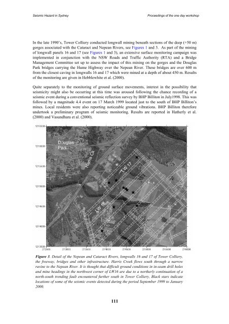
Seismic Hazard <strong>in</strong> <strong>Sydney</strong>Proceed<strong>in</strong>gs of <strong>the</strong> one day workshopIn <strong>the</strong> late 1990’s, Tower Colliery conducted longwall m<strong>in</strong><strong>in</strong>g beneath sections of <strong>the</strong> deep (+50 m)gorges associated with <strong>the</strong> Cataract and Nepean Rivers, see Figures 1 and 3. As part of <strong>the</strong> m<strong>in</strong><strong>in</strong>gof longwall panels 16 and 17 (see Figures 1 and 3), an extensive surface monitor<strong>in</strong>g campaign wasimplemented <strong>in</strong> conjunction with <strong>the</strong> NSW Roads and Traffic Authority (RTA) and a BridgeManagement Committee set up to assess <strong>the</strong> impact of this m<strong>in</strong><strong>in</strong>g on <strong>the</strong> gorges and <strong>the</strong> DouglasPark bridges carry<strong>in</strong>g <strong>the</strong> Hume Highway over <strong>the</strong> Nepean River. These bridges are over 600 mfrom <strong>the</strong> closest cav<strong>in</strong>g <strong>in</strong> longwalls 16 and 17 which were m<strong>in</strong>ed at a depth of about 450 m. Resultsof <strong>the</strong> monitor<strong>in</strong>g are given <strong>in</strong> Hebblewhite et al. (2000).Quite separately to <strong>the</strong> monitor<strong>in</strong>g of ground surface movements, <strong>in</strong>terest <strong>in</strong> <strong>the</strong> possibility thatseismicity might also be occurr<strong>in</strong>g at this time was aroused follow<strong>in</strong>g <strong>the</strong> chance record<strong>in</strong>g of aseismic event dur<strong>in</strong>g a conventional seismic reflection survey by BHP Billiton <strong>in</strong> July1998. This wasfollowed by a magnitude 4.4 event on 17 March 1999 located just to <strong>the</strong> south of BHP Billiton’sm<strong>in</strong>es. Local residents were also report<strong>in</strong>g noticeable ground vibrations. BHP Billiton <strong>the</strong>reforeundertook a prelim<strong>in</strong>ary program of seismic monitor<strong>in</strong>g. Results are reported <strong>in</strong> Ha<strong>the</strong>rly et al.(2000) and Vasundhara et al. (2000).DouglasParkHarris CkLW 17LW 16Figure 3. Detail of <strong>the</strong> Nepean and Cataract Rivers, longwalls 16 and 17 of Tower Colliery,<strong>the</strong> freeway, bridges and o<strong>the</strong>r <strong>in</strong>frastructure. Harris Creek flows south through a narrowrav<strong>in</strong>e to <strong>the</strong> Nepean River. It is thought that difficult ground conditions <strong>in</strong> <strong>in</strong>-seam drill holesand m<strong>in</strong>e head<strong>in</strong>gs <strong>in</strong> <strong>the</strong> northwest corner of LW16 are due to a nor<strong>the</strong>rly cont<strong>in</strong>uation of anorth-south trend<strong>in</strong>g fault encountered fur<strong>the</strong>r south <strong>in</strong> Tower Colliery. Black stars <strong>in</strong>dicatelocations of some of <strong>the</strong> seismic events detected dur<strong>in</strong>g <strong>the</strong> period September 1999 to January2000.111
Seismic Hazard <strong>in</strong> <strong>Sydney</strong>Proceed<strong>in</strong>gs of <strong>the</strong> one day workshopIn this paper, results of <strong>the</strong>se two monitor<strong>in</strong>g programs are summarized and we present somethoughts on <strong>the</strong> mechanisms that may be <strong>in</strong>volved.MONITORING OF THE DOUGLAS PARK BRIDGESThe monitor<strong>in</strong>g program <strong>in</strong>stituted by <strong>the</strong> Bridge Management Committee consisted of <strong>the</strong> follow<strong>in</strong>g(Hebblewhite et al., 2000). GPS monitor<strong>in</strong>g of targets across <strong>the</strong> terra<strong>in</strong> for horizontal movement. Conventional precise level<strong>in</strong>g and <strong>the</strong>odolite surveys <strong>in</strong> selected, accessible traverse l<strong>in</strong>es across<strong>the</strong> overall terra<strong>in</strong>, gorges and adjacent to, and on <strong>the</strong> bridge, pier and foundation structures.EDM surveys on gorge closure at nom<strong>in</strong>ated cross gorge locations.Remote electronic monitor<strong>in</strong>g of critical locations on <strong>the</strong> bridge decks, expansion gaps, bear<strong>in</strong>gand o<strong>the</strong>r key structural locations.The results of this study confirmed that although <strong>the</strong> bridge structure underwent some significantlateral movement towards <strong>the</strong> m<strong>in</strong><strong>in</strong>g location, its serviceability was never compromised. In <strong>the</strong>vic<strong>in</strong>ity of <strong>the</strong> bridges, <strong>the</strong> majority of <strong>the</strong> movement was of a regional ‘rigid body’ nature, with <strong>the</strong>bridge and <strong>the</strong> surrounds mov<strong>in</strong>g en-masse towards <strong>the</strong> m<strong>in</strong>e. There was movement of 65 mm due to<strong>the</strong> m<strong>in</strong><strong>in</strong>g of LW16 and a fur<strong>the</strong>r 70 mm due to LW17. Directly above <strong>the</strong> longwall panels,subsidence was also observed as well as gorge closure and some degree of relative ‘upsidence’. It is<strong>the</strong> large amounts of regional, horizontal ground movement, extend<strong>in</strong>g over quite considerabledistances away from <strong>the</strong> m<strong>in</strong><strong>in</strong>g that are of most <strong>in</strong>terest <strong>in</strong> this paper.SEISMIC EVENTSThe seismic monitor<strong>in</strong>g was undertaken between August 1999 and June 2000 us<strong>in</strong>g 15 short periodseismographs made available by <strong>the</strong> <strong>Australia</strong>n National Seismic Imag<strong>in</strong>g Resource (ANSIR). Withno knowledge of where <strong>the</strong> seismicity, if any, would be located, <strong>the</strong> units were deployed across BHPBilliton’s m<strong>in</strong><strong>in</strong>g leases <strong>in</strong> <strong>the</strong> App<strong>in</strong> area. The vertical component of <strong>the</strong> ground motion was ma<strong>in</strong>lyrecorded.From this program of monitor<strong>in</strong>g, it was found that <strong>the</strong>re were occasional seismic events that couldbe correlated over distances of about 6 km. The locations of <strong>the</strong>se (see Figure 3) were found to be <strong>in</strong><strong>the</strong> vic<strong>in</strong>ity of Tower Colliery and <strong>the</strong> Nepean and Cataract River gorges. Some were also felt byresidents.The depths of <strong>the</strong> events are thought to have been less than 1 km. Their tim<strong>in</strong>g did not necessarilyco<strong>in</strong>cide with periods of active m<strong>in</strong><strong>in</strong>g as is <strong>the</strong> case with <strong>the</strong> much smaller microseismic eventscaused by rock fractur<strong>in</strong>g dur<strong>in</strong>g longwall cav<strong>in</strong>g (see Ha<strong>the</strong>rly et al., 2003, for example). However,by June 2000 when <strong>the</strong> m<strong>in</strong><strong>in</strong>g of longwall 17 was completed, <strong>the</strong> seismic activity ceased.DISCUSSIONHebblewhite et al. (2000), discuss potential mechanisms for <strong>the</strong> observed subsidence and <strong>the</strong> lateralmovement of <strong>the</strong> bridges towards <strong>the</strong> m<strong>in</strong>e. To expla<strong>in</strong> <strong>the</strong> lateral movement, three mechanismswere proposed.relaxation of strata <strong>in</strong> <strong>the</strong> direction of <strong>the</strong> pr<strong>in</strong>cipal horizontal stress towards <strong>the</strong> sides of <strong>the</strong>longwall panels,activation of geological structures, and<strong>the</strong> cantilever<strong>in</strong>g of massive strata.112