

Landslides in the Sydney Basin - Geoscience Australia
Landslides in the Sydney Basin - Geoscience Australia
Landslides in the Sydney Basin - Geoscience Australia
- No tags were found...

You also want an ePaper? Increase the reach of your titles
YUMPU automatically turns print PDFs into web optimized ePapers that Google loves.
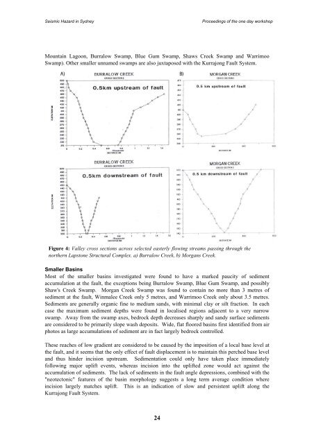
Seismic Hazard <strong>in</strong> <strong>Sydney</strong>Proceed<strong>in</strong>gs of <strong>the</strong> one day workshopMounta<strong>in</strong> Lagoon, Burralow Swamp, Blue Gum Swamp, Shaws Creek Swamp and WarrimooSwamp). O<strong>the</strong>r smaller unnamed swamps are also juxtaposed with <strong>the</strong> Kurrajong Fault System.Figure 4: Valley cross sections across selected easterly flow<strong>in</strong>g streams pass<strong>in</strong>g through <strong>the</strong>nor<strong>the</strong>rn Lapstone Structural Complex. a) Burralow Creek, b) Morgans Creek.Smaller Bas<strong>in</strong>sMost of <strong>the</strong> smaller bas<strong>in</strong>s <strong>in</strong>vestigated were found to have a marked paucity of sedimentaccumulation at <strong>the</strong> fault, <strong>the</strong> exceptions be<strong>in</strong>g Burralow Swamp, Blue Gum Swamp, and possiblyShaw's Creek Swamp. Morgan Creek Swamp was found to conta<strong>in</strong> no more than 3 metres ofsediment at <strong>the</strong> fault, W<strong>in</strong>malee Creek only 5 metres, and Warrimoo Creek only about 3.5 metres.Sediments are generally organic f<strong>in</strong>e to medium sands, with m<strong>in</strong>imal clay or silt fraction. In eachcase <strong>the</strong> maximum sediment depths were found <strong>in</strong> localised regions adjacent to a very narrowswamp. Away from <strong>the</strong> swamp axes, bedrock depth decreases sharply and sandy surface sedimentsare considered to be primarily slope wash deposits. Wide, flat floored bas<strong>in</strong>s first identified from airphotos as large accumulations of sediment are <strong>in</strong> fact largely bedrock controlled.These reaches of low gradient are considered to be caused by <strong>the</strong> imposition of a local base level at<strong>the</strong> fault, and it seems that <strong>the</strong> only effect of fault displacement is to ma<strong>in</strong>ta<strong>in</strong> this perched base leveland thus h<strong>in</strong>der <strong>in</strong>cision upstream. Sedimentation could only have taken place immediatelyfollow<strong>in</strong>g major uplift events, whereas <strong>in</strong>cision <strong>in</strong>to <strong>the</strong> uplifted zone would act aga<strong>in</strong>st <strong>the</strong>accumulation of sediments. The lack of sediments <strong>in</strong> <strong>the</strong> fault angle depressions, comb<strong>in</strong>ed with <strong>the</strong>"neotectonic" features of <strong>the</strong> bas<strong>in</strong> morphology suggests a long term average condition where<strong>in</strong>cision largely matches uplift. This is an <strong>in</strong>dication of slow and persistent uplift along <strong>the</strong>Kurrajong Fault System.24


