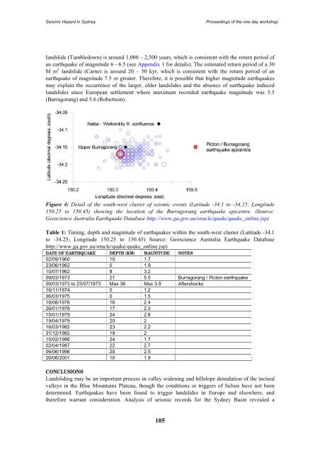
Seismic Hazard <strong>in</strong> <strong>Sydney</strong>Proceed<strong>in</strong>gs of <strong>the</strong> one day workshoplandslide (Tumbledown) is around 1,000 – 2,500 years, which is consistent with <strong>the</strong> return period ofan earthquake of magnitude 6 - 6.5 (see Appendix 1 for details). The estimated return period of a 30M m 3 landslide (Carne) is around 20 – 50 kyr, which is consistent with <strong>the</strong> return period of anearthquake of magnitude 7.5 or greater. Therefore, it is possible that higher magnitude earthquakesmay expla<strong>in</strong> <strong>the</strong> occurrence of <strong>the</strong> larger, older landslides and <strong>the</strong> absence of earthquake <strong>in</strong>ducedlandslides s<strong>in</strong>ce European settlement where maximum recorded earthquake magnitude was 5.5(Burragorang) and 5.6 (Robertson).Figure 4: Detail of <strong>the</strong> south-west cluster of seismic events (Latitude -34.1 to -34.25; Longitude150.25 to 150.45) show<strong>in</strong>g <strong>the</strong> location of <strong>the</strong> Burragorang earthquake epicentre. (Source:<strong>Geoscience</strong> <strong>Australia</strong> Earthquake Database http://www.ga.gov.au/oracle/quake/quake_onl<strong>in</strong>e.jsp)Table 1: Tim<strong>in</strong>g, depth and magnitude of earthquakes with<strong>in</strong> <strong>the</strong> south-west cluster (Latitude -34.1to -34.25; Longitude 150.25 to 150.45) Source: <strong>Geoscience</strong> <strong>Australia</strong> Earthquake Databasehttp://www.ga.gov.au/oracle/quake/quake_onl<strong>in</strong>e.jsp)DATE OF EARTHQUAKE DEPTH (KM) MAGNITUDE NOTES02/09/1960 10 1.723/06/1962 0 1.910/07/1962 8 3.209/03/1973 21 5.5 Burragorang / Picton earthquake09/03/1973 to 23/07/1973 Max 38 Max 3.9 Aftershocks16/11/1974 0 1.206/03/1975 0 1.518/08/1976 16 2.426/01/1978 17 2.315/01/1979 24 2.819/04/1979 20 216/03/1982 23 2.231/12/1982 19 215/02/1986 24 1.702/04/1987 22 2.706/06/1996 20 2.526/06/2001 10 1.9CONCLUSIONSLandslid<strong>in</strong>g may be an important process <strong>in</strong> valley widen<strong>in</strong>g and hillslope denudation of <strong>the</strong> <strong>in</strong>cisedvalleys <strong>in</strong> <strong>the</strong> Blue Mounta<strong>in</strong>s Plateau, though <strong>the</strong> conditions or triggers of failure have not beendeterm<strong>in</strong>ed. Earthquakes have been found to trigger landslides <strong>in</strong> Europe and elsewhere, and<strong>the</strong>refore warrant consideration. Analysis of seismic records for <strong>the</strong> <strong>Sydney</strong> Bas<strong>in</strong> revealed a105
Seismic Hazard <strong>in</strong> <strong>Sydney</strong>Proceed<strong>in</strong>gs of <strong>the</strong> one day workshopclustered distribution of earthquakes particularly <strong>in</strong> <strong>the</strong> south-west of <strong>the</strong> bas<strong>in</strong> at UpperBurragorang. The south-west cluster co<strong>in</strong>cides with <strong>the</strong> occurrence of several large pre-Europeanlandslides. The age of <strong>the</strong> landslides however, precludes establish<strong>in</strong>g a clear association. The onlylandslides to occur with<strong>in</strong> <strong>the</strong> period of record do not show a consistent overlap <strong>in</strong> <strong>the</strong> tim<strong>in</strong>g offailure and are thought to be a direct response to underground coal m<strong>in</strong><strong>in</strong>g. The largest magnitudeearthquakes on record (5.5 and 5.6), however, may not have been significant enough to trigger slopefailure. It may be that <strong>the</strong> larger, older landslides were triggered by higher magnitude events but weare unable to confirm this.ACKNOWLEDGMENTSThis contribution forms part of a collaborative research program with <strong>the</strong> <strong>Sydney</strong> CatchmentAuthority (2003/28).REFERENCESBembrick, C.S., Herbert, C., Scheibner, E., and Stuntz, J. 1973. Structural subdivision of <strong>the</strong> NewSouth Wales portion of <strong>the</strong> <strong>Sydney</strong> - Bowen Bas<strong>in</strong>. Quarterly Notes of <strong>the</strong> Geological Surveyof NSW 11: 1-13.Berryman, K., and Stirl<strong>in</strong>g, M. 2003. Earthquake ground motion and fault hazard studies at <strong>the</strong>Lucas Heights Research Reactor Facility, <strong>Sydney</strong>, <strong>Australia</strong>: evolution of methods andchanges <strong>in</strong> results. International Symposium on Seismic Evaluation of Exist<strong>in</strong>g NuclearFacilities, Vienna. August 2003, 43-47.Branagan, D.F., and Pedram, H. 1990. The Lapstone Structural Complex, New South Wales.<strong>Australia</strong>n Journal of Earth Sciences 37: 23-36.Brunker, R.L., and Rose, G. 1967. <strong>Sydney</strong> Bas<strong>in</strong> 1:500,000 Geological Sheet (Special). New SouthWales Department of M<strong>in</strong>es, <strong>Sydney</strong>.Cunn<strong>in</strong>gham, D.M. 1988. A rockfall avalanche <strong>in</strong> a sandstone landscape, Nattai North NSW.<strong>Australia</strong>n Geographer 19 (2): 221-229.Dadson, S.J., Hovius, N., Chen, H., Dade, W.B., Hsieh, M.-L., Willett, S.D., Hu, J.-C., Horng, M.-J.,Chen, M.-C., Stark, C.P., Lague, D., and L<strong>in</strong>, J.-C. 2003. L<strong>in</strong>ks between erosion, runoffvariability and seismicity <strong>in</strong> <strong>the</strong> Taiwan orogen. Nature 426: 648-651.Denham, D. 1976. Effects of <strong>the</strong> 1973 Picton and o<strong>the</strong>r earthquakes <strong>in</strong> Eastern <strong>Australia</strong>. Bullet<strong>in</strong> -<strong>Australia</strong>, Bureau of M<strong>in</strong>eral Resources, Geology and Geophysics 164: 15-27.Drake, L. 1974. The Seismicity of New South Wales. Journal and Proceed<strong>in</strong>gs of <strong>the</strong> Royal Societyof New South Wales 107: 35-40.— 1976. Seismic risk <strong>in</strong> New South Wales. Bullet<strong>in</strong> - <strong>Australia</strong>, Bureau of M<strong>in</strong>eral Resources,Geology and Geophysics 164: 5-8.E<strong>the</strong>ridge, R. 1893. Geological and ethnological observations made <strong>in</strong> <strong>the</strong> valley of <strong>the</strong> WollondillyRiver, at its junction near <strong>the</strong> Nattai River, counties Camden and Westmoreland. Records of<strong>the</strong> <strong>Australia</strong>n Museum 2 (4): 46-54.Keefer, D.K. 1984. <strong>Landslides</strong> caused by earthquakes. Geological Society of America Bullet<strong>in</strong> 95:406-421.— 1994. The importance of earthquake-<strong>in</strong>duced landslides to long-term slope erosion and slopefailurehazards <strong>in</strong> seismically active regions. Geomorphology 10: 265-284.Lithografica Artistica Cartographica 1979. <strong>Sydney</strong> and Environs 1:200,000 raised relief map. Geo-Maps Company, <strong>Sydney</strong>.Macris, J. 2002. Processes of Valley Slope Evolution; Evidence from <strong>the</strong> Western Blue Mounta<strong>in</strong>s,NSW. [Unpublished Honours <strong>the</strong>sis] Macquarie University, <strong>Sydney</strong>.McCue, K. 1999. The cause of current <strong>Australia</strong>n <strong>in</strong>traplate volcanism. ACES Inaugural Workshop,31 January - 5 February 1999. Brisbane / Noosa, Queensland, <strong>Australia</strong>, 509-512.106