

Landslides in the Sydney Basin - Geoscience Australia
Landslides in the Sydney Basin - Geoscience Australia
Landslides in the Sydney Basin - Geoscience Australia
- No tags were found...

Create successful ePaper yourself
Turn your PDF publications into a flip-book with our unique Google optimized e-Paper software.
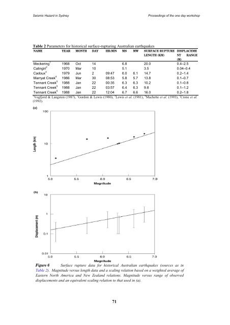
Seismic Hazard <strong>in</strong> <strong>Sydney</strong>Proceed<strong>in</strong>gs of <strong>the</strong> one day workshopTable 2 Parameters for historical surface-ruptur<strong>in</strong>g <strong>Australia</strong>n earthquakesNAME YEAR MONTH DAY HR:MIN MS MW SURFACE RUPTURE DISPLACEMELENGTH (KM) NT RANGE(M)Mecker<strong>in</strong>g 1 1968 Oct 14 6.8 20.0 0.4–2.5Cal<strong>in</strong>giri 2 1970 Mar 10 5.1 3.5 0.04–0.4Cadoux 3 1979 Jun 2 09:47 6.0 6.1 14.7 0.2–1.4Marryat Creek 4 1986 Mar 30 08:53 5.8 5.7 13.8 0.1–0.7Tennant Creek 5 1988 Jan 22 00:35 6.3 6.3 10.2 0.1–0.8Tennant Creek 5 1988 Jan 22 03:57 6.4 6.3 9.8 0.1–1.2Tennant Creek 5 1988 Jan 22 12:04 6.7 6.6 16.0 0.2–1.81 Vogfjord & Langston (1987), 2 Gordon & Lewis (1980), 3 Lewis et al. (1981), 4 Machette et al. (1993), 5 Crone et al.(1992).Figure 6 Surface rupture data for historical <strong>Australia</strong>n earthquakes (sources as <strong>in</strong>Table 2). Magnitude versus length data and a scal<strong>in</strong>g relation based on a weighted average ofEastern North America and New Zealand relations. Magnitude versus range of observeddisplacements and an equivalent scal<strong>in</strong>g relation to that used <strong>in</strong> (a).


