

Landslides in the Sydney Basin - Geoscience Australia
Landslides in the Sydney Basin - Geoscience Australia
Landslides in the Sydney Basin - Geoscience Australia
- No tags were found...

You also want an ePaper? Increase the reach of your titles
YUMPU automatically turns print PDFs into web optimized ePapers that Google loves.
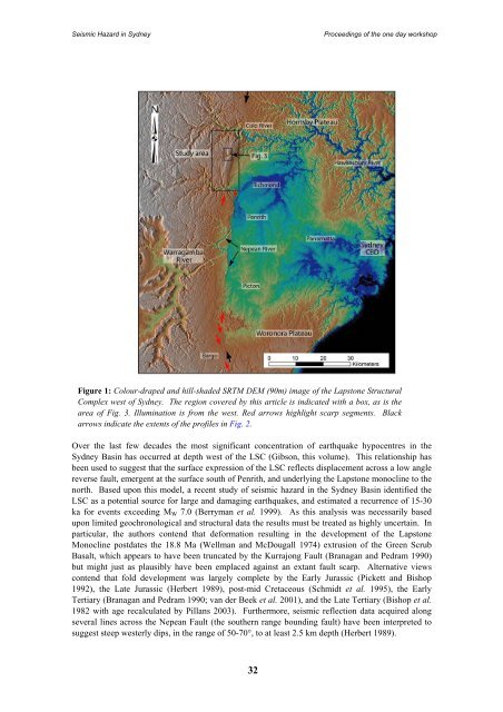
Seismic Hazard <strong>in</strong> <strong>Sydney</strong>Proceed<strong>in</strong>gs of <strong>the</strong> one day workshopFigure 1: Colour-draped and hill-shaded SRTM DEM (90m) image of <strong>the</strong> Lapstone StructuralComplex west of <strong>Sydney</strong>. The region covered by this article is <strong>in</strong>dicated with a box, as is <strong>the</strong>area of Fig. 3. Illum<strong>in</strong>ation is from <strong>the</strong> west. Red arrows highlight scarp segments. Blackarrows <strong>in</strong>dicate <strong>the</strong> extents of <strong>the</strong> profiles <strong>in</strong> Fig. 2.Over <strong>the</strong> last few decades <strong>the</strong> most significant concentration of earthquake hypocentres <strong>in</strong> <strong>the</strong><strong>Sydney</strong> Bas<strong>in</strong> has occurred at depth west of <strong>the</strong> LSC (Gibson, this volume). This relationship hasbeen used to suggest that <strong>the</strong> surface expression of <strong>the</strong> LSC reflects displacement across a low anglereverse fault, emergent at <strong>the</strong> surface south of Penrith, and underly<strong>in</strong>g <strong>the</strong> Lapstone monocl<strong>in</strong>e to <strong>the</strong>north. Based upon this model, a recent study of seismic hazard <strong>in</strong> <strong>the</strong> <strong>Sydney</strong> Bas<strong>in</strong> identified <strong>the</strong>LSC as a potential source for large and damag<strong>in</strong>g earthquakes, and estimated a recurrence of 15-30ka for events exceed<strong>in</strong>g M W 7.0 (Berryman et al. 1999). As this analysis was necessarily basedupon limited geochronological and structural data <strong>the</strong> results must be treated as highly uncerta<strong>in</strong>. Inparticular, <strong>the</strong> authors contend that deformation result<strong>in</strong>g <strong>in</strong> <strong>the</strong> development of <strong>the</strong> LapstoneMonocl<strong>in</strong>e postdates <strong>the</strong> 18.8 Ma (Wellman and McDougall 1974) extrusion of <strong>the</strong> Green ScrubBasalt, which appears to have been truncated by <strong>the</strong> Kurrajong Fault (Branagan and Pedram 1990)but might just as plausibly have been emplaced aga<strong>in</strong>st an extant fault scarp. Alternative viewscontend that fold development was largely complete by <strong>the</strong> Early Jurassic (Pickett and Bishop1992), <strong>the</strong> Late Jurassic (Herbert 1989), post-mid Cretaceous (Schmidt et al. 1995), <strong>the</strong> EarlyTertiary (Branagan and Pedram 1990; van der Beek et al. 2001), and <strong>the</strong> Late Tertiary (Bishop et al.1982 with age recalculated by Pillans 2003). Fur<strong>the</strong>rmore, seismic reflection data acquired alongseveral l<strong>in</strong>es across <strong>the</strong> Nepean Fault (<strong>the</strong> sou<strong>the</strong>rn range bound<strong>in</strong>g fault) have been <strong>in</strong>terpreted tosuggest steep westerly dips, <strong>in</strong> <strong>the</strong> range of 50-70°, to at least 2.5 km depth (Herbert 1989).32


