Seismic Hazard <strong>in</strong> <strong>Sydney</strong>Proceed<strong>in</strong>gs of <strong>the</strong> one day workshopMcElroy, C.T., and Relph, R.E. 1958. Explanatory notes to accompany geological maps of <strong>the</strong> <strong>in</strong>nercatchment, Warragamba storage. Department of M<strong>in</strong>es, Geological Survey of NSW, <strong>Sydney</strong>.Mills, J.M., and Fitch, T.J. 1977. Thrust fault<strong>in</strong>g and crust - upper mantle structure <strong>in</strong> East <strong>Australia</strong>.Geophysical Journal of <strong>the</strong> Royal Astronomical Society 48: 351-384.MWSDB 1974. Seismological <strong>in</strong>vestigations. Burragorang earthquake and aftershocks. Map andreport. Metropolitan Water Sewerage and Dra<strong>in</strong>age Board, <strong>Sydney</strong>.Pells, P.J.N., Braybrooke, J.C., Mong, J., and Kotze, G.P. 1987. Cliff l<strong>in</strong>e collapse associated withm<strong>in</strong><strong>in</strong>g activities. <strong>in</strong> Walker, B.F., and Fell, R., eds., Soil Slope Instability and StabilisationBalkema, Rotterdam, 359-385.Reynolds, R.G. 1976. Coal m<strong>in</strong><strong>in</strong>g under stored water: report on an <strong>in</strong>quiry <strong>in</strong>to coal m<strong>in</strong><strong>in</strong>g underor <strong>in</strong> <strong>the</strong> vic<strong>in</strong>ity of <strong>the</strong> stored waters of <strong>the</strong> Nepean, Avon, Cordeaux, Cataract and WoronoraReservoirs, New South Wales, <strong>Australia</strong>. Department of Public Works, <strong>Sydney</strong>.Rib, H.T., and Liang, T. 1978. Recognition and identification. In <strong>Landslides</strong> Analysis and Control,Schuster, R.L., and Krizek, R.J., (eds). National Academy of Sciences, Wash<strong>in</strong>gton; 34-80.S<strong>in</strong>ad<strong>in</strong>ovski, C., McCue, K., and Somerville, M. 2000. Characteristics of strong ground motion fortypical <strong>Australia</strong>n <strong>in</strong>tra-plate earthquakes and <strong>the</strong>ir relationship with <strong>the</strong> recommendedresponse spectra. Soil Dynamics and Earthquake Eng<strong>in</strong>eer<strong>in</strong>g 20: 101-110.Taylor, G.M. 2005. <strong>Landslides</strong> around Lake Burragorang: <strong>the</strong>ir characteristics, distribution andimpact potential. [Unpublished Honours <strong>the</strong>sis] Macquarie University, <strong>Sydney</strong>.Tomk<strong>in</strong>s, K.M., Humphreys, G.S., Skeen, H.J., Taylor, G.M., Farwig, V.J., Shakesby, R.A., Doerr,S.H., Wallbr<strong>in</strong>k, P., Blake, W.H., and Chafer, C.J. 2004b. Decipher<strong>in</strong>g a colluvial mantle:Nattai catchment. SuperSoil 2004: Program and Abstracts for <strong>the</strong> 3rd <strong>Australia</strong>n and NewZealand Soils Conference. University of <strong>Sydney</strong>, <strong>Australia</strong>,www.regional.org.au/au/asssi/supersoil2004.van der Beek, P., Pulford, A., and Braun, J. 2001. Cenozoic landscape development <strong>in</strong> <strong>the</strong> BlueMounta<strong>in</strong>s (SE <strong>Australia</strong>): Lithological and tectonic controls on rifted marg<strong>in</strong> morphology.The Journal of Geology 109: 35-56.Walker, P.H. 1963. Soil history and debris-avalanche deposits along <strong>the</strong> Illawarra scarpland.<strong>Australia</strong>n Journal of Soil Research 1 (1): 223-230.Wellman, P., and McDougall, I. 1974. Potassium-argon ages on <strong>the</strong> Ca<strong>in</strong>ozoic volcanic rocks ofNew South Wales. Journal of <strong>the</strong> Geological Society of <strong>Australia</strong> 21 (3): 247-272.Young, A.R.M. 1977. The characteristics and orig<strong>in</strong> of coarse debris deposits near Wollongong,N.S.W., <strong>Australia</strong>. Catena 4: 289-307.107
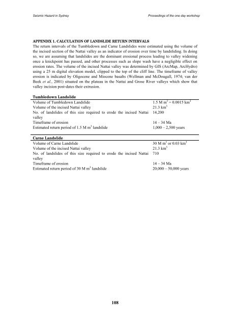
Seismic Hazard <strong>in</strong> <strong>Sydney</strong>Proceed<strong>in</strong>gs of <strong>the</strong> one day workshopAPPENDIX 1. CALCULATION OF LANDSLIDE RETURN INTERVALSThe return <strong>in</strong>tervals of <strong>the</strong> Tumbledown and Carne <strong>Landslides</strong> were estimated us<strong>in</strong>g <strong>the</strong> volume of<strong>the</strong> <strong>in</strong>cised section of <strong>the</strong> Nattai valley as an <strong>in</strong>dicator of erosion over time by landslid<strong>in</strong>g. In do<strong>in</strong>gso, we are assum<strong>in</strong>g that landslides are <strong>the</strong> dom<strong>in</strong>ant erosional process lead<strong>in</strong>g to valley widen<strong>in</strong>gonce a knickpo<strong>in</strong>t has passed, and o<strong>the</strong>r processes such as slope wash have a negligible effect onerosion rates. The volume of <strong>the</strong> <strong>in</strong>cised Nattai valley was determ<strong>in</strong>ed by GIS (ArcMap, ArcHydro)us<strong>in</strong>g a 25 m digital elevation model, clipped to <strong>the</strong> top of <strong>the</strong> cliff l<strong>in</strong>e. The timeframe of valleyerosion is <strong>in</strong>dicated by Oligocene and Miocene basalts (Wellman and McDougall, 1974; van derBeek et al., 2001) situated on <strong>the</strong> plateau <strong>in</strong> <strong>the</strong> Nattai and Grose River valleys which show thatvalley <strong>in</strong>cision post-dates <strong>the</strong>ir extrusion.Tumbledown LandslideVolume of Tumbledown Landslide 1.5 M m 3 = 0.0015 km 3Volume of <strong>the</strong> <strong>in</strong>cised Nattai valley 21.3 km 3No. of landslides of this size required to erode <strong>the</strong> <strong>in</strong>cised Nattai 14,200valleyTimeframe of erosion14 – 34 MaEstimated return period of 1.5 M m 3 landslide1,000 – 2,500 yearsCarne LandslideVolume of Carne Landslide 30 M m 3 or 0.03 km 3Volume of <strong>the</strong> <strong>in</strong>cised Nattai valley 21.3 km 3No. of landslides of this size required to erode <strong>the</strong> <strong>in</strong>cised Nattai 710valleyTimeframe of erosion14 – 34 MaEstimated return period of 30 M m 3 landslide20,000 – 50,000 years108