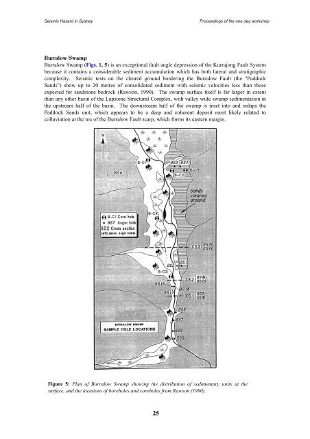
Seismic Hazard <strong>in</strong> <strong>Sydney</strong>Proceed<strong>in</strong>gs of <strong>the</strong> one day workshopBurralow SwampBurralow Swamp (Figs. 1, 5) is an exceptional fault angle depression of <strong>the</strong> Kurrajong Fault Systembecause it conta<strong>in</strong>s a considerable sediment accumulation which has both lateral and stratigraphiccomplexity. Seismic tests on <strong>the</strong> cleared ground border<strong>in</strong>g <strong>the</strong> Burralow Fault (<strong>the</strong> "PaddockSands") show up to 20 metres of consolidated sediment with seismic velocities less than thoseexpected for sandstone bedrock (Rawson, 1990). The swamp surface itself is far larger <strong>in</strong> extentthan any o<strong>the</strong>r bas<strong>in</strong> of <strong>the</strong> Lapstone Structural Complex, with valley wide swamp sedimentation <strong>in</strong><strong>the</strong> upstream half of <strong>the</strong> bas<strong>in</strong>. The downstream half of <strong>the</strong> swamp is <strong>in</strong>set <strong>in</strong>to and onlaps <strong>the</strong>Paddock Sands unit, which appears to be a deep and coherent deposit most likely related tocolluviation at <strong>the</strong> toe of <strong>the</strong> Burralow Fault scarp, which forms its eastern marg<strong>in</strong>.Figure 5: Plan of Burralow Swamp show<strong>in</strong>g <strong>the</strong> distribution of sedimentary units at <strong>the</strong>surface, and <strong>the</strong> locations of boreholes and coreholes from Rawson (1990).25
Seismic Hazard <strong>in</strong> <strong>Sydney</strong>Proceed<strong>in</strong>gs of <strong>the</strong> one day workshopFigure 5: Plan of Burralow Swamp show<strong>in</strong>g <strong>the</strong> distribution of sedimentary units at <strong>the</strong>surface, and <strong>the</strong> locations of boreholes and coreholes from Rawson (1990).Drill<strong>in</strong>g carried out on <strong>the</strong> downstream end of <strong>the</strong> valley floor has shown that although <strong>the</strong> presentsurficial sediments are dom<strong>in</strong>ated by sands, <strong>the</strong>re is evidence of a persistent large swamp or lake <strong>in</strong><strong>the</strong> past. This is <strong>in</strong>dicated by an extensive deposit of organic clay/silt sediment (denoted <strong>the</strong>Tabaraga Unit, Rawson 1990) which locally reaches up to 6-7 metres thick and extends down todepths <strong>in</strong> excess of 10 metres (Fig. 6). The unit rapidly th<strong>in</strong>s <strong>in</strong> a downstream direction and p<strong>in</strong>chesout aga<strong>in</strong>st a steeply ris<strong>in</strong>g bedrock bar relat<strong>in</strong>g to <strong>the</strong> Burralow Fault. We contend that this depositis <strong>the</strong> result of tectonic rejuvenation whereby movement of <strong>the</strong> Burralow Fault has imposed anew, relatively higher, perched base-level lead<strong>in</strong>g to disruption of dra<strong>in</strong>age. Sandy strataextend<strong>in</strong>g from <strong>the</strong> top of <strong>the</strong> f<strong>in</strong>es to <strong>the</strong> surface are <strong>in</strong>terpreted to have been deposited dur<strong>in</strong>g<strong>the</strong> progressive restoration of <strong>the</strong> creek to pre-fault<strong>in</strong>g conditions.Figure 6: Longitud<strong>in</strong>al section through Burralow swamp show<strong>in</strong>g <strong>the</strong> distribution of <strong>the</strong> clayrichTabaraga Unit, <strong>in</strong>ferred to be related to uplift of 6-7 m on <strong>the</strong> Burralow Fault.Tim<strong>in</strong>g of Sedimentation <strong>in</strong> Burralow SwampHav<strong>in</strong>g established that sedimentation with<strong>in</strong> Burralow Swamp has been markedly affected bydisplacement on <strong>the</strong> Burralow Fault, <strong>the</strong> age of sediments with<strong>in</strong> it should reflect <strong>the</strong> onset of atleast <strong>the</strong> most recent phase of activity. Two radiocarbon ages were obta<strong>in</strong>ed from smallcharcoal samples from borehole B-C4 (Fig. 5; Rawson, 1990). The first, at a depth of 12.90metres, came from coarse sandy sediments beneath <strong>the</strong> organic clays/silts of <strong>the</strong> Tabaraga Unit.This should <strong>in</strong>dicate <strong>the</strong> age of pre-deformation fluvial sedimentation. The age obta<strong>in</strong>ed was28200 (+900/-800) BP (SUA-2873). The second sample, from with<strong>in</strong> <strong>the</strong> clayey unit at 8.80metres, was dated at 35400 (+2400 -1990) BP (SUA-2874). The <strong>in</strong>version of <strong>the</strong> dates isproblematic, and might relate ei<strong>the</strong>r to contam<strong>in</strong>ation of one or both of <strong>the</strong> samples, orredeposition of <strong>the</strong> top sample. The fact that both dates lie close to <strong>the</strong> limit of <strong>the</strong> dat<strong>in</strong>gtechnique also reduces <strong>the</strong> confidence that can be placed <strong>in</strong> <strong>the</strong>m.Sedimentological evidence does, however, mitigate <strong>in</strong> favour of accept<strong>in</strong>g <strong>the</strong> dates, or at least alate Pleistocene age for <strong>the</strong> sediments. Both dates came from samples of clean, un<strong>in</strong>duratedcharcoal, which had no obvious contam<strong>in</strong>ation (eg. coat<strong>in</strong>gs, recrystallisation, or evidence of26