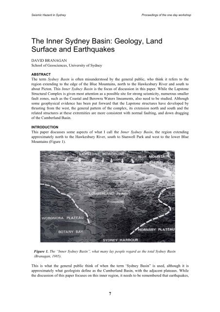
Seismic Hazard <strong>in</strong> <strong>Sydney</strong>Proceed<strong>in</strong>gs of <strong>the</strong> one day workshopThe Inner <strong>Sydney</strong> Bas<strong>in</strong>: Geology, LandSurface and EarthquakesDAVID BRANAGANSchool of <strong>Geoscience</strong>s, University of <strong>Sydney</strong>ABSTRACTThe term <strong>Sydney</strong> Bas<strong>in</strong> is often misunderstood by <strong>the</strong> general public, who th<strong>in</strong>k it refers to <strong>the</strong>region extend<strong>in</strong>g to <strong>the</strong> edge of <strong>the</strong> Blue Mounta<strong>in</strong>s, north to <strong>the</strong> Hawkesbury River and south toabout Picton. This Inner <strong>Sydney</strong> Bas<strong>in</strong> is <strong>the</strong> focus of discussion <strong>in</strong> this paper. While <strong>the</strong> LapstoneStructural Complex is given most attention as a possible site for strong seismicity, numerous smallerfault zones, such as <strong>the</strong> Coastal and Berowra Waters l<strong>in</strong>eaments, also need to be studied. Althoughsome geophysical evidence has been put forward that <strong>the</strong> Lapstone structures have developed bythrust<strong>in</strong>g from <strong>the</strong> west, <strong>the</strong> general pattern of <strong>the</strong> complex, its extension north and south and <strong>the</strong>related structures at <strong>the</strong>se extremities are more consistent with normal fault<strong>in</strong>g, and down dragg<strong>in</strong>gof <strong>the</strong> Cumberland Bas<strong>in</strong>.INTRODUCTIONThis paper discusses some aspects of what I call <strong>the</strong> Inner <strong>Sydney</strong> Bas<strong>in</strong>, <strong>the</strong> region extend<strong>in</strong>gapproximately north to <strong>the</strong> Hawkesbury River, south to Stanwell Park and west to <strong>the</strong> lower BlueMounta<strong>in</strong>s (Figure 1).Figure 1. The “Inner <strong>Sydney</strong> Bas<strong>in</strong>”, what many lay people regard as <strong>the</strong> total <strong>Sydney</strong> Bas<strong>in</strong>(Branagan, 1985).This is what <strong>the</strong> general public th<strong>in</strong>k of when <strong>the</strong> term ‘<strong>Sydney</strong> Bas<strong>in</strong>” is used, although it isapproximately what geologists def<strong>in</strong>e as <strong>the</strong> Cumberland Bas<strong>in</strong>, with <strong>the</strong> adjacent plateaux. While<strong>the</strong> discussion of this paper focuses on this <strong>in</strong>ner region, it needs to be remembered that earthquakes,7
Seismic Hazard <strong>in</strong> <strong>Sydney</strong>Proceed<strong>in</strong>gs of <strong>the</strong> one day workshopanywhere <strong>in</strong> <strong>the</strong> whole <strong>Sydney</strong> Bas<strong>in</strong>, as def<strong>in</strong>ed by geologists, and even beyond, can affect <strong>the</strong><strong>in</strong>ner region and its man-made structures.The region consists dom<strong>in</strong>antly of sedimentary rocks deposited <strong>in</strong> <strong>the</strong> Permian and Triassic periods(about 260 – 200 million years before present (B.P.)). In <strong>the</strong> <strong>Sydney</strong> region <strong>the</strong> Triassic rocks areexposed. The underly<strong>in</strong>g Permian rocks are exposed on <strong>the</strong> south coast (from Stanwell Park andsouth), to <strong>the</strong> north around Lake Macquarie to Newcastle and <strong>in</strong> <strong>the</strong> valleys of <strong>the</strong> western BlueMounta<strong>in</strong>s. In <strong>the</strong> <strong>Sydney</strong> region <strong>the</strong> Permian rocks are at about 900m deep. In a few places <strong>the</strong>se‘solid’ Triassic and Permian rocks have a relatively th<strong>in</strong> cover (say 100m) of mostly unconsolidatedsediments of Pleistocene to Recent age (2 million BP), notably around Botany Bay, <strong>the</strong> PenrithLakes, and Maroota (to <strong>the</strong> north west).Igneous activity has occurred, but is not extensive. It consists of both <strong>in</strong>trusions and extrusions. In<strong>the</strong> <strong>in</strong>ner <strong>Sydney</strong> region <strong>the</strong>se range <strong>in</strong> age from about 200 Ma to 15Ma. Volcanic necks such as atHornsby, Dundas, Nortons and Bents Bas<strong>in</strong>s, <strong>the</strong> dist<strong>in</strong>ctive Prospect <strong>in</strong>trusion, and numerous dykeshave been mapped. The dykes appear to be commoner <strong>in</strong> <strong>the</strong> eastern (coastal) area. This might be amatter of better exposure on <strong>the</strong> coast than across <strong>the</strong> Cumberland Pla<strong>in</strong>, although dykes arecerta<strong>in</strong>ly rare <strong>in</strong> <strong>the</strong> Blue Mounta<strong>in</strong>s.While <strong>the</strong> sedimentary succession is generally flat-ly<strong>in</strong>g, <strong>the</strong>re is clear evidence of m<strong>in</strong>or fold<strong>in</strong>gdur<strong>in</strong>g deposition, and <strong>the</strong>re is also post-depositional fold<strong>in</strong>g and fault<strong>in</strong>g. Some of this postdepositionaldeformation can be attributed to <strong>the</strong> last phases of movement of <strong>the</strong> Hunter-BowenThrust System (Moelle and Branagan, 1987; Mills et al, 1989; Branagan, 2000a and 2000b), buto<strong>the</strong>r later activity occurred, ma<strong>in</strong>ly <strong>in</strong> <strong>the</strong> period 80 – 20 Ma.Even with<strong>in</strong> <strong>the</strong> “<strong>in</strong>ner <strong>Sydney</strong> Bas<strong>in</strong>” we can recognise smaller bas<strong>in</strong>s and domes, which reflect<strong>the</strong>se deformations. The most obvious is <strong>the</strong> Botany Bas<strong>in</strong>, which is also, <strong>in</strong>cidentally, <strong>the</strong> site of <strong>the</strong>thickest succession of young sediments (Tertiary – Ca<strong>in</strong>ozoic). These sediments will react to seismicshak<strong>in</strong>g quite differently to <strong>the</strong> older, consolidated rocks, as happened <strong>in</strong> <strong>the</strong> Newcastle regiondur<strong>in</strong>g <strong>the</strong> 1989 earthquake.Evidence <strong>in</strong>dicates that both compression and tension have occurred dur<strong>in</strong>g and after deposition, and<strong>the</strong>re appear to have been two long periods of tension – at <strong>the</strong> end of major deposition (LateTriassic), and Early Tertiary (sea-floor spread<strong>in</strong>g), as <strong>in</strong>dicated particularly by <strong>the</strong> dyke <strong>in</strong>trusions.POSSIBLE SITES OF SEISMIC ACTIVITYEmphasis has been given to <strong>the</strong> Lapstone Structural Complex as a likely site of strong seismicactivity (based on past seismic records. However it is pert<strong>in</strong>ent to po<strong>in</strong>t out o<strong>the</strong>r structuralweaknesses that have been mapped <strong>in</strong> <strong>the</strong> <strong>Sydney</strong> region <strong>in</strong> <strong>the</strong> past thirty years. Although <strong>the</strong>semostly show little or no signs of geologically recent activation, <strong>the</strong>y should not be entirelydiscounted as sites of seismic activity. At <strong>the</strong> various sites mapped a variety of fault types canbe recognised. They <strong>in</strong>clude normal, steep reverse, overthrust, strike-slip and fault breccia(crushed rock) varieties. It is not unusual to f<strong>in</strong>d several different fault types <strong>in</strong> close proximity.This is not to be unexpected, as once a rock mass has been weakened by fault<strong>in</strong>g it is quitelikely to be <strong>the</strong> locus of fur<strong>the</strong>r fault<strong>in</strong>g, and although one might expect similar movements ashad taken place previously, <strong>the</strong> weak material could easily deform <strong>in</strong> a new way. Although alittle removed from <strong>the</strong> “<strong>in</strong>ner <strong>Sydney</strong> Bas<strong>in</strong>”, <strong>the</strong> fault systems mapped just east of <strong>the</strong> MooneyMooney Creek Bridge on <strong>the</strong> F 4 Freeway, are a particularly good example of such deformation.Here reverse fold<strong>in</strong>g/fault<strong>in</strong>g, normal and strike-slip faults have been recorded (Mills et al., op.cit.).8