environment
environment
environment
- No tags were found...

Create successful ePaper yourself
Turn your PDF publications into a flip-book with our unique Google optimized e-Paper software.
Vol. 11 No. 1 2004<br />
The dirtiest river of England<br />
By P.M. Maurenbrecher<br />
It was a case of taming the River Tame. Yes,”Tame” and<br />
not “Thames”. The River Tame is one of the few rivers<br />
that become contaminated at its source. Birmingham<br />
lies at the heart of England on the watershed between<br />
the west and east. The name Birmingham is synonymous<br />
with industry, heavy industry and lots of pollution. The<br />
Tame is an upper and main tributary of the River Trent<br />
whose estuary is the Humber.<br />
My colleagues in the London office of Binnie and<br />
Partners commiserated with me when they heard I was<br />
the unfortunate to act as “resident engineer” on a site<br />
investigation for a project to clean up the river. This<br />
was in the days when the word “<strong>environment</strong>” or in the<br />
Netherlands “milieu” was just starting to make a<br />
tentative impact. Possibly it was because it was the<br />
winter of 1973/74 when I was to go up north. Going<br />
north of London was like being banished to Siberia, as<br />
the north was ugly and was ravaged by industry<br />
meaning mining, steel works, heavy machinery and lots<br />
of chemical installations.<br />
I was not disappointed when I settled into “The Swan”<br />
at Coleshill Warwickshire. Coleshill was a typically rural<br />
Midlands English town which could support the cast<br />
of a Englands most favourite English serial/soap “The<br />
Archers”. Coleshill had seen better days and could<br />
emulate towns to the south if its buildings were<br />
renovated and restored. Two pictures show “The Swan”<br />
as an inn one would expect from the English tourist<br />
brochures as well as Colehill’s parish church. But that<br />
was all that Coleshill had to show off: it had views of<br />
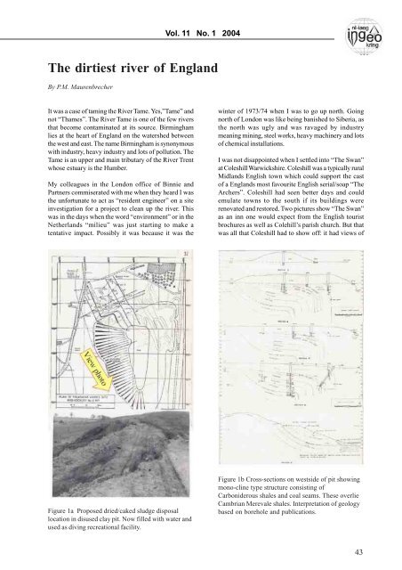
Figure 1a Proposed dried/caked sludge disposal<br />
location in disused clay pit. Now filled with water and<br />
used as diving recreational facility.<br />
Figure 1b Cross-sections on westside of pit showing<br />
mono-cline type structure consisting of<br />
Carboniderous shales and coal seams. These overlie<br />
Cambrian Merevale shales. Interpretation of geology<br />
based on borehole and publications.<br />
43