environment
environment
environment
- No tags were found...

You also want an ePaper? Increase the reach of your titles
YUMPU automatically turns print PDFs into web optimized ePapers that Google loves.
Ingeokring Newsletter<br />
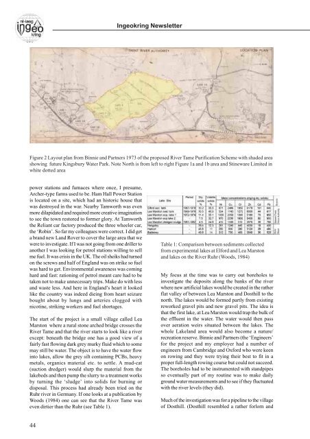
Figure 2 Layout plan from Binnie and Partners 1973 of the proposed River Tame Purification Scheme with shaded area<br />
showing future Kingsbury Water Park. Note North is from left to right Figure 1a and 1b area and Stineware Limited in<br />
white dotted area<br />
power stations and furnaces where once, I presume,<br />
Archer-type farms used to be. Ham Hall Power Station<br />
is located on a site, which had an historic house that<br />
was destroyed in the war. Nearby Tamworth was even<br />
more dilapidated and required more creative imagination<br />
to see the town restored to former glory. At Tamworth<br />
the Reliant car factory produced the three wheeler car,<br />
the ‘Robin’. So far my colleagues were correct. I did get<br />
a brand new Land Rover to cover the large area that we<br />
were to investigate. If I was not going from one driller to<br />
another I was looking for petrol stations willing to sell<br />
me fuel. It was crisis in the UK. The oil sheiks had turned<br />
on the screws and half of England was on strike so fuel<br />
was hard to get. Environmental awareness was coming<br />
hard and fast: rationing of petrol meant care had to be<br />
taken not to make unnecessary trips. Make do with less<br />
and waste less. And here in England’s heart it looked<br />
like the country was indeed dieing from heart seizure<br />
bought about by lungs and arteries clogged with<br />
nicotine, striking workers and fuel shortages.<br />
The start of the project is a small village called Lea<br />
Marston where a rural stone arched bridge crosses the<br />
River Tame and that the river starts to look like a river<br />
except: beneath the bridge one has a good view of a<br />
fairly fast flowing dark grey murky fluid which to some<br />
may still be water. The object is to have the water flow<br />
into lakes, allow the grey silt containing PCBs, heavy<br />
metals, organics material etc. to settle. A mud-cat<br />
(suction dredger) would slurp the material from the<br />
lakebeds and then pump the slurry to a treatment works<br />
by turning the ‘sludge’ into solids for burning or<br />
disposal. This process had already been tried on the<br />
Ruhr river in Germany. If one looks at a publication by<br />
Woods (1984) one can see that the River Tame was<br />
even dirtier than the Ruhr (see Table 1).<br />
Table 1: Comparison between sediments collected<br />
from experimental lakes at Elford and Lea Marston<br />
and lakes on the River Ruhr (Woods, 1984)<br />
My focus at the time was to carry out boreholes to<br />
investigate the deposits along the banks of the river<br />
where new artificial lakes would be created in the rather<br />
flat valley of between Lea Marston and Dosthill to the<br />
north. The lakes would be formed partly from existing<br />
reworked gravel pits and new gravel pits. The idea is<br />
that the first lake, at Lea Marston would trap the bulk of<br />
the effluent in the water. The water would then pass<br />
over aeration weirs situated between the lakes. The<br />
whole Lakeland area would also become a nature/<br />
recreation reserve. Binnie and Partners (the ‘Engineers’<br />
for the project and my employer had a number of<br />
engineers from Cambridge and Oxford who were keen<br />
on rowing and they were trying their best to fit in a<br />
proper full-length rowing course but could not succeed.<br />
The boreholes had to be instrumented with standpipes<br />
so eventually part of my routine was to make daily<br />
ground water measurements and to see if they fluctuated<br />
with the river levels (they did).<br />
Much of the investigation was for a pipeline to the village<br />
of Dosthill. (Dosthill resembled a rather forlorn and<br />
44