The Earliest Inhabitants: The Dynamics of the Jamaican Taino
by Lesley-Gail Atkinson
by Lesley-Gail Atkinson

Create successful ePaper yourself
Turn your PDF publications into a flip-book with our unique Google optimized e-Paper software.
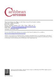
SOUTH<br />
NEGRIL<br />
POINT<br />
Savannala-Mar<br />
Montego Bay<br />
JAMAICA<br />
GALINA POINT<br />
Green Castle<br />
Estate<br />
Mandeville<br />
May Pen<br />
Spanish<br />
Town<br />
KINGSTON<br />
MORANT<br />
POINT<br />
PORTLAND<br />
POINT<br />
32 km<br />
20 mi.<br />
Figure 4.1 Location <strong>of</strong> Green Castle<br />
University, and during <strong>the</strong> last season by <strong>the</strong> National Geographic Society and<br />
<strong>the</strong> Reed Foundation. <strong>The</strong> details given below are taken from <strong>the</strong> preliminary<br />
annual reports on <strong>the</strong> excavations which have so far been submitted<br />
(Allsworth-Jones and Wesler 1999–2001).<br />
<strong>The</strong> general position <strong>of</strong> <strong>the</strong> site is indicated on <strong>the</strong> map in Figure 4.1. It is<br />
a hilltop overlooking <strong>the</strong> sea, and <strong>the</strong> contours <strong>of</strong> <strong>the</strong> hilltop are shown in<br />
Figure 4.2. Over <strong>the</strong> three years, six trenches were excavated, designated<br />
according to <strong>the</strong>ir position in relation to site datum. <strong>The</strong> three westernmost<br />
trenches, excavated in 2000, were shallow and yielded very little information.<br />
<strong>The</strong> nor<strong>the</strong>rnmost trench (0–2S 9–10E) was also quite shallow and was evidently<br />
affected by erosion and deflation. Conditions were quite different for<br />
<strong>the</strong> middle trench on <strong>the</strong> eastern side (30–31S 7–10E, later extended to east<br />
and north) and <strong>the</strong> sou<strong>the</strong>rnmost trench on <strong>the</strong> eastern side (58–60S 5–6E).<br />
<strong>The</strong> sou<strong>the</strong>rnmost trench produced <strong>the</strong> most complete stratigraphy, to a maximum<br />
depth <strong>of</strong> 1.5 m. On its eastern side, <strong>the</strong> middle trench reached a maximum<br />
depth <strong>of</strong> 80 cm. Three consecutive occupations were detected in <strong>the</strong><br />
sou<strong>the</strong>rnmost trench, separated by reddish, gravelly, more or less sterile layers.<br />
<strong>The</strong> difference between <strong>the</strong> two lowest occupations was particularly clearly<br />
marked, <strong>the</strong> basal level being completely sealed by a horizon <strong>of</strong> large loose<br />
rubble up to 25 cm thick. <strong>The</strong> situation was much more complex in <strong>the</strong> eastern<br />
part <strong>of</strong> <strong>the</strong> middle trench, where it became apparent from 2000 onwards<br />
that we were dealing with an artificially cut burial pit and probably o<strong>the</strong>r cutand-fill<br />
features as well. In 2001 a complete adult burial was uncovered here,<br />
lying on bedrock.<br />
A number <strong>of</strong> radiocarbon dates for <strong>the</strong> site have been obtained from <strong>the</strong><br />
Beta Analytic laboratory. For <strong>the</strong> sou<strong>the</strong>rn trench <strong>the</strong>y are as follows.<br />
Occupation 3 Level 2: 330 ± 60 BP (cal AD 1470–1645)<br />
Level 3: 430 ± 80 BP (cal AD 1420–1616)<br />
Occupation 2 Level 7: 760 ± 60 BP (cal AD 1221–1291)<br />
70 T HE E ARLIEST I NHABITANTS