Sistemas de guiado GreenStar - StellarSupport - John Deere
Sistemas de guiado GreenStar - StellarSupport - John Deere
Sistemas de guiado GreenStar - StellarSupport - John Deere

Create successful ePaper yourself
Turn your PDF publications into a flip-book with our unique Google optimized e-Paper software.
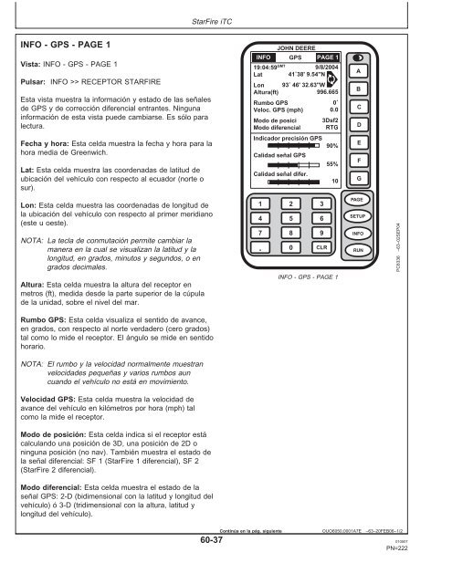
INFO-GPS-PAGE1<br />
Vista: INFO - GPS - PAGE 1<br />
Pulsar: INFO >> RECEPTOR STARFIRE<br />
Esta vista muestra la información y estado <strong>de</strong> las señales<br />
<strong>de</strong> GPS y <strong>de</strong> corrección diferencial entrantes. Ninguna<br />
información <strong>de</strong> esta vista pue<strong>de</strong> cambiarse. Es sólo para<br />
lectura.<br />
StarFire iTC<br />
Fecha y hora: Esta celda muestra la fecha y hora para la<br />
hora media <strong>de</strong> Greenwich.<br />
Lat: Esta celda muestra las coor<strong>de</strong>nadas <strong>de</strong> latitud <strong>de</strong><br />
ubicación <strong>de</strong>l vehículo con respecto al ecuador (norte o<br />
sur).<br />
Lon: Esta celda muestra las coor<strong>de</strong>nadas <strong>de</strong> longitud <strong>de</strong><br />
la ubicación <strong>de</strong>l vehículo con respecto al primer meridiano<br />
(este u oeste).<br />
NOTA: La tecla <strong>de</strong> conmutación permite cambiar la<br />
manera en la cual se visualizan la latitud y la<br />
longitud, en grados, minutos y segundos, o en<br />
grados <strong>de</strong>cimales.<br />
Altura: Esta celda muestra la altura <strong>de</strong>l receptor en<br />
metros (ft), medida <strong>de</strong>s<strong>de</strong> la parte superior <strong>de</strong> la cúpula<br />
<strong>de</strong> la unidad, sobre el nivel <strong>de</strong>l mar.<br />
Rumbo GPS: Esta celda visualiza el sentido <strong>de</strong> avance,<br />
en grados, con respecto al norte verda<strong>de</strong>ro (cero grados)<br />
tal como lo mi<strong>de</strong> el receptor. El ángulo se mi<strong>de</strong> en sentido<br />
horario.<br />
NOTA: El rumbo y la velocidad normalmente muestran<br />
velocida<strong>de</strong>s pequeñas y varios rumbos aun<br />
cuando el vehículo no está en movimiento.<br />
Velocidad GPS: Esta celda muestra la velocidad <strong>de</strong><br />
avance <strong>de</strong>l vehículo en kilómetros por hora (mph) tal<br />
como la mi<strong>de</strong> el receptor.<br />
Modo <strong>de</strong> posición: Esta celda indica si el receptor está<br />
calculando una posición <strong>de</strong> 3D, una posición <strong>de</strong>2Do<br />
ninguna posición (no nav). También muestra el estado <strong>de</strong><br />
la señal diferencial: SF 1 (StarFire 1 diferencial), SF 2<br />
(StarFire 2 diferencial).<br />
Modo diferencial: Esta celda muestra el estado <strong>de</strong> la<br />
señal GPS: 2-D (bidimensional con la latitud y longitud <strong>de</strong>l<br />
vehículo) ó 3-D (tridimensional con la altura, latitud y<br />
longitud <strong>de</strong>l vehículo).<br />
1<br />
4<br />
7<br />
.<br />
JOHN DEERE<br />
GPS<br />
19:04:59GMT INFO PAGE 1<br />
9/8/2004<br />
Lat 41˚38' 9.54"N<br />
Lon 93˚ 46' 32.63"W<br />
Altura(ft)<br />
996.665<br />
Rumbo GPS<br />
0˚<br />
Veloc. GPS (mph) 0.0<br />
Modo <strong>de</strong> posici 3Dsf2<br />
Modo diferencial RTG<br />
Indicador precisión GPS<br />
90%<br />
Calidad señal GPS<br />
Calidad señal difer.<br />
Continúa enlapág. siguiente<br />
2<br />
5<br />
8<br />
0<br />
3<br />
6<br />
9<br />
CLR<br />
55%<br />
10<br />
INFO - GPS - PAGE 1<br />
A<br />
B<br />
C<br />
D<br />
E<br />
F<br />
G<br />
PAGE<br />
SETUP<br />
INFO<br />
RUN<br />
PC8336 –63–02SEP04<br />
OUO6050,0001A7E –63–20FEB06–1/2<br />
60-37 010507<br />
PN=222