1957 - United Nations Statistics Division
1957 - United Nations Statistics Division
1957 - United Nations Statistics Division
You also want an ePaper? Increase the reach of your titles
YUMPU automatically turns print PDFs into web optimized ePapers that Google loves.
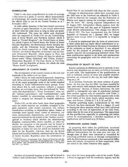
NOMENCLATURE<br />
Table I-the most comprehensive in terms of coverage<br />
-also serves as a guide to current official nomenclature<br />
or terminology, the country names used in Table 1 being<br />
the official titles in use in the <strong>United</strong> <strong>Nations</strong> as of 1<br />
November <strong>1957</strong>.1<br />
In other tables, however, it has been found convenient<br />
-because of space limitations-to use certain abbreviated<br />
or short titles for some areas so long as these are generally<br />
understood. The areas for which such shortened<br />
titles are employed in Tables 3-31 are the <strong>United</strong> Kingdom<br />
of Great Britain and Northern Ireland, which is<br />
listed as "<strong>United</strong> Kingdom"; the <strong>United</strong> States of America,<br />
which is given as <strong>United</strong> States; the Union of Soviet<br />
Socialist Republics, the Byelorussian Soviet Socialist Republic,<br />
and the Ukrainian Soviet Socialist Republic,<br />
which are listed respectively as USSR, Byelorussia, and<br />
Ukraine; the Federal Republic of Germany and the German<br />
Democratic Republic, which appear as West and<br />
East Germany respectively; China, the data for which are<br />
shown under "China, Mainland" and "China, Taiwan";<br />
Democratic Republic of Viet-Nam shown as Viet-Nam,<br />
North and the Republic of Korea, for which the term<br />
"Korea, South" is employed.<br />
ARRANGEMENT OF COUNTRY NAMES<br />
The arrangement of the country names in the stub and<br />
boxheads of the tables is of two types.<br />
Table I shows, for each continent separately (beginning<br />
with Africa and proceeding in English alphabetic order) ,<br />
all of the major geographic units of the world classified<br />
according to broad administrative-status groups. Countries<br />
shown first in each continent, without a category<br />
heading, are sovereign areas; they are followed by "territories<br />
and dependencies", "Trust Territories", areas under<br />
"military government", and "condominiums", each<br />
further classified by administering authority. All areas<br />
within a category are arranged in English alphabetic<br />
order.<br />
Tables 3-31, on the other hand, show those geographic<br />
units for which statistics are available, arranged in English<br />
alphabetic order within continents, but without<br />
classification according to dependency status. Names of<br />
sovereign states appear alone; names of territories, colonies,<br />
protectorates, dependencies, and overseas departments<br />
are followed by the initials of the "mother country"<br />
(placed in brackets) which identify the administering<br />
kingdom, commonwealth, union, republic, or other authority.<br />
An exception to this practice may be found in<br />
connexion with Sikkim, which is a protectorate of the<br />
Republic of India but data for which are included with<br />
those for the Republic. Likewise, data for the Kurile<br />
Islands and Southern Sakhalin, administered by the Union<br />
of Soviet Socialist Republics since the termination of<br />
1 <strong>United</strong> <strong>Nations</strong>. Terminology Unit. Names of Countries and Adjectives<br />
of Nationality. Document ST/CS/SER.F/127, 8 March <strong>1957</strong>,<br />
23 p. Mimeo. Also document ST/CS/SER.F/127/Add. 1,19 September<br />
<strong>1957</strong>, 1 p. Mimeo.<br />
<strong>Statistics</strong> of territorial expanse or area will be found in<br />
Tables I and 2 of this issue. Table I shows the most recent<br />
AREA<br />
14<br />
World War II, are included with those for that country.<br />
Changes in administration which have occurred since<br />
the 1956 issue of the Yearbook are reflected in Table I.<br />
It will be observed, for example, that the Federation of<br />
Malaya now appears among the sovereign countries, under<br />
the letter "M", having acquired independence on<br />
31 August <strong>1957</strong>. Independent Ghana replaces both the<br />
former Gold Coast and that part of Togoland formerly<br />
under British administration. This change was effective<br />
6 March <strong>1957</strong>. The Saar, incorporated into the Federal<br />
Republic of Germany on I January <strong>1957</strong>, no longer<br />
appears alone except where it is impossible to integrate<br />
the data.<br />
It should be emphasized that the form of presentation<br />
in these tables does not imply official endorsement or acceptance<br />
by the <strong>United</strong> <strong>Nations</strong> of the status or boundaries<br />
of the territories as listed or described. It was adopted<br />
solely for the purpose of providing a convenient geographic<br />
basis for the accompanying statistical series. The<br />
same qualification applies to all notes and explanations<br />
concerning the geographic units for which data are presented.<br />
EVALUATION OF QUALITY OF DATA<br />
Known variations in definitions and in methods of estimation<br />
and tabulation are, as usual, set forth in footnotes<br />
to each table. The implications of the qualifications, as<br />
well as technical sources of error and possible misinterpretation,<br />
are reviewed in the text for each table beginning<br />
on p. 18.<br />
As in previous Yearbooks, the latest estimate of population<br />
(in this case, that for 1956) has been classified by<br />
type, and current vital statistics have been evaluated for<br />
"completeness". Because of format limitations, the code<br />
applied to distinguish one type of population estimate<br />
from another appears only in connexion with Table I;<br />
that which qualifies the vital statistics appears only in the<br />
trend tables of live birth, death, infant mortality, marriage,<br />
and divorce (Tables 6, 7, 8, 9, 22 and 23) .<br />
Another qualifying index, re-introduced in the 1953<br />
Yearbook, has been continued. This is a dagger (t) used<br />
to distinguish those statistics which have been tabulated<br />
according to the year of registration of the vital event,<br />
rather than by the year of its occurrence. The importance<br />
of this qualification, especially in evaluating live births,<br />
cannot be overemphasized; a detailed exposition of its<br />
implications will be found on p. 25 below.<br />
DISCREPANCIES AMONG TABLES<br />
In preparing these tables for publication, occasional<br />
slight disparities were found in the statistics dealing with<br />
different characteristics for the same area and year. Although<br />
most of these were corrected or reconciled by<br />
co.nsulting published sources or through correspondence<br />
WIth the Governments concerned, a few unresolved differences<br />
still remain. Irrespective of their magnitude, these<br />
are noted in the tables wherever they appear.<br />
area value for every geographic unit of the world; Table<br />
2 shows an aggregate area for continents, regions, and the


