Garmin: Nuvi 3500 Series Owner's Manual
Garmin: Nuvi 3500 Series Owner's Manual
Garmin: Nuvi 3500 Series Owner's Manual

Create successful ePaper yourself
Turn your PDF publications into a flip-book with our unique Google optimized e-Paper software.
NOTE: You can change the types of public<br />
transit and limit the distance spent walking<br />
during a pedestrian route (page 64).<br />
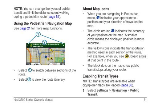
Using the Pedestrian Navigation Map<br />
See page 21 for more map functions.<br />
➊<br />
➋<br />
• Select ➊ to switch between sections of the<br />
route.<br />
• Select ➋ to view the route itinerary.<br />
About Map Icons<br />
• When you are navigating in Pedestrian<br />
mode, indicates your approximate<br />
position and your direction of travel on the<br />
map.<br />
• The circle around indicates the accuracy<br />
of your position on the map. A smaller<br />
circle means the displayed position is more<br />
accurate.<br />
• The yellow icons indicate the transportation<br />
method used in each section of the route.<br />
For example, when you see , board a bus<br />
at that point in the route.<br />
• The black dots on the map show public<br />
transit stops along your route.<br />
Enabling Transit Types<br />
NOTE: Transit types are available when<br />
cityXplorer maps are loaded (page 30).<br />
1 Select Settings > Navigation > Public<br />
Transit.<br />
nüvi <strong>3500</strong> <strong>Series</strong> Owner’s <strong>Manual</strong> 31