

A Natural Areas Inventory of the - Kansas Natural Heritage Inventory ...
A Natural Areas Inventory of the - Kansas Natural Heritage Inventory ...
A Natural Areas Inventory of the - Kansas Natural Heritage Inventory ...

Create successful ePaper yourself
Turn your PDF publications into a flip-book with our unique Google optimized e-Paper software.
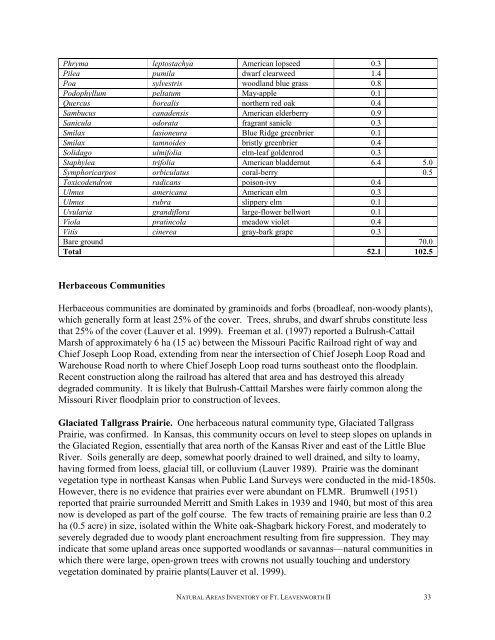
Phryma leptostachya American lopseed 0.3<br />
Pilea pumila dwarf clearweed 1.4<br />
Poa sylvestris woodland blue grass 0.8<br />
Podophyllum peltatum May-apple 0.1<br />
Quercus borealis nor<strong>the</strong>rn red oak 0.4<br />
Sambucus canadensis American elderberry 0.9<br />
Sanicula odorata fragrant sanicle 0.3<br />
Smilax lasioneura Blue Ridge greenbrier 0.1<br />
Smilax tamnoides bristly greenbrier 0.4<br />
Solidago ulmifolia elm-leaf goldenrod 0.3<br />
Staphylea trifolia American bladdernut 6.4 5.0<br />
Symphoricarpos orbiculatus coral-berry 0.5<br />
Toxicodendron radicans poison-ivy 0.4<br />
Ulmus americana American elm 0.3<br />
Ulmus rubra slippery elm 0.1<br />
Uvularia grandiflora large-flower bellwort 0.1<br />
Viola pratincola meadow violet 0.4<br />
Vitis cinerea gray-bark grape 0.3<br />
Bare ground 70.0<br />
Total 52.1 102.5<br />
Herbaceous Communities<br />
Herbaceous communities are dominated by graminoids and forbs (broadleaf, non-woody plants),<br />
which generally form at least 25% <strong>of</strong> <strong>the</strong> cover. Trees, shrubs, and dwarf shrubs constitute less<br />
that 25% <strong>of</strong> <strong>the</strong> cover (Lauver et al. 1999). Freeman et al. (1997) reported a Bulrush-Cattail<br />
Marsh <strong>of</strong> approximately 6 ha (15 ac) between <strong>the</strong> Missouri Pacific Railroad right <strong>of</strong> way and<br />
Chief Joseph Loop Road, extending from near <strong>the</strong> intersection <strong>of</strong> Chief Joseph Loop Road and<br />
Warehouse Road north to where Chief Joseph Loop road turns sou<strong>the</strong>ast onto <strong>the</strong> floodplain.<br />
Recent construction along <strong>the</strong> railroad has altered that area and has destroyed this already<br />
degraded community. It is likely that Bulrush-Catttail Marshes were fairly common along <strong>the</strong><br />
Missouri River floodplain prior to construction <strong>of</strong> levees.<br />
Glaciated Tallgrass Prairie. One herbaceous natural community type, Glaciated Tallgrass<br />
Prairie, was confirmed. In <strong>Kansas</strong>, this community occurs on level to steep slopes on uplands in<br />
<strong>the</strong> Glaciated Region, essentially that area north <strong>of</strong> <strong>the</strong> <strong>Kansas</strong> River and east <strong>of</strong> <strong>the</strong> Little Blue<br />
River. Soils generally are deep, somewhat poorly drained to well drained, and silty to loamy,<br />
having formed from loess, glacial till, or colluvium (Lauver 1989). Prairie was <strong>the</strong> dominant<br />
vegetation type in nor<strong>the</strong>ast <strong>Kansas</strong> when Public Land Surveys were conducted in <strong>the</strong> mid-1850s.<br />
However, <strong>the</strong>re is no evidence that prairies ever were abundant on FLMR. Brumwell (1951)<br />
reported that prairie surrounded Merritt and Smith Lakes in 1939 and 1940, but most <strong>of</strong> this area<br />
now is developed as part <strong>of</strong> <strong>the</strong> golf course. The few tracts <strong>of</strong> remaining prairie are less than 0.2<br />
ha (0.5 acre) in size, isolated within <strong>the</strong> White oak-Shagbark hickory Forest, and moderately to<br />
severely degraded due to woody plant encroachment resulting from fire suppression. They may<br />
indicate that some upland areas once supported woodlands or savannas—natural communities in<br />
which <strong>the</strong>re were large, open-grown trees with crowns not usually touching and understory<br />
vegetation dominated by prairie plants(Lauver et al. 1999).<br />
NATURAL AREAS INVENTORY OF FT. LEAVENWORTH II 33