

A Natural Areas Inventory of the - Kansas Natural Heritage Inventory ...
A Natural Areas Inventory of the - Kansas Natural Heritage Inventory ...
A Natural Areas Inventory of the - Kansas Natural Heritage Inventory ...

Create successful ePaper yourself
Turn your PDF publications into a flip-book with our unique Google optimized e-Paper software.
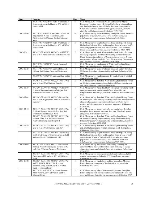
Date Location Time Notes<br />
39.3611°N, 94.9278°W; bluffs W <strong>of</strong> N end <strong>of</strong><br />
Sherman Army Airfield and ca 0.75 mi NE <strong>of</strong><br />
Hancock Hill<br />
2003-06-04 39.3720°N, 94.8952°W and points to ca 1 NE<br />
on peninsula; N side <strong>of</strong> Sherman Army<br />
Airfield, just S <strong>of</strong> Weston Bend <strong>of</strong> Missouri<br />
River<br />
39.3611°N, 94.9278°W; bluffs W <strong>of</strong> N end <strong>of</strong><br />
Sherman Army Airfield and ca 0.75 mi NE <strong>of</strong><br />
Hancock Hill<br />
2003-06-11 39.3657°–39.3676°N, 94.9349°– 94.9297°W;<br />
area to N <strong>of</strong> water reservoir, E <strong>of</strong> Hancock Hill<br />
39.3718°N, 94.9320°W; Fort de Cavagnial<br />
Picnic Area<br />
2003-06-23 39.3711°N, 94.9337°W; area E <strong>of</strong> Hancock<br />
Hill and S <strong>of</strong> Fort de Cavagnial Picnic Area<br />
6 C. A. Morse, C. C. Freeman & W. D. Kettle: survey Maple-<br />
Basswood Forest on steep, NE-facing bluffs above Missouri River<br />
and floodplain forest at base <strong>of</strong> bluffs; document populations <strong>of</strong><br />
Carex hitchcockiana, Hydrophyllum appendiculatum, Packera<br />
glabella, and Rubus alumnus. Collections 9390–9402.<br />
6 C. A. Morse: survey Pecan-Hackberry Floodplain Forest; document<br />
populations <strong>of</strong> Carex crus-corvi, Carex radiata, and Carex<br />
tribuloides var. sangamonensis. Collections 9445–9664.<br />
2 C. A. Morse: survey Maple-Basswood forest on steep, NE-facing<br />
bluffs above Missouri River and floodplain forest at base <strong>of</strong> bluffs;<br />
document populations <strong>of</strong> Carex hitchcockiana, Carex normalis,<br />
Carex rosea, and Osmorhiza claytonii. Collections 9465–9472.<br />
7 C. A. Morse: survey mesic White oak-Shagbark hickory Forest on<br />
NE-facing slopes and floodplain forest along tributary to Quarry<br />
Creek; document populations <strong>of</strong> Brachyelytrum erectum, Bromus<br />
nottawayanus, Carex hirtifolia, Carex hitchcockiana, Carex rosea,<br />
and Osmorhiza claytonii. Collections 9478–9511.<br />
1 C. A. Morse: survey weedy edge <strong>of</strong> White oak-Shagbark hickory<br />
Forest and mowed parkland. Collections 9512–9520.<br />
4 C. A. Morse: survey mesic White oak-Shagbark hickory Forest on<br />
SE-facing slope along tributary to Quarry Creek. Collections 9684–<br />
9689.<br />
39.3590°N, 94.9424°W; area near Hunt Lodge 1 C. A. Morse: survey weedy seep and dry creek at base <strong>of</strong> wooded<br />
slope. Collection 9690.<br />
39.3497°–39.3504°N, 94.9332°–94.9373°W; 2 C. A. Morse: survey disturbed White oak-Shagbark hickory Forest<br />
area to N and W <strong>of</strong> National Cemetery<br />
on SE-facing slope; document populations <strong>of</strong> Osmorhiza claytonii<br />
and Rubus alumnus. Collections 9691–9797.<br />
2003-06-27 39.3720°–39.3905°N, 94.8952°– 94.8891°W; 7 C. A. Morse: survey Pecan-Hackberry Floodplain Forest and weedy<br />
N side <strong>of</strong> Sherman Army Airfield, just S <strong>of</strong><br />
openings; document populations <strong>of</strong> Carex tribuloides var.<br />
Weston Bend <strong>of</strong> Missouri River<br />
sangamonensis and Stachys pilosa var. arenicola. Collections 9708–<br />
9727.<br />
2003-07-02 39.3526°–39.3545°N, 94.9391°–94.9304°W; 8 C. A. Morse: survey disturbed White oak-Shagbark hickory Forest<br />
area to E <strong>of</strong> Wagner Point and NW <strong>of</strong> National<br />
on steep slopes above tributary to Quarry Creek and floodplain forest<br />
Cemetery<br />
along creek; document populations <strong>of</strong> Carex hirtifolia, Carex<br />
radiata, and Ranunculus recurvatus var. recurvatus. Collections<br />
9728–9748.<br />
2003-07-18 39.3541°–39.3649°N, 94.9112°–94.8940°W; 3 C. A. Morse: survey muddy bank <strong>of</strong> river, weedy levy, disturbed<br />
E side <strong>of</strong> Sherman Army Airfield, just S <strong>of</strong><br />
floodplain forest between levee and river, and Eleocharis marsh<br />
Weston Bend <strong>of</strong> Missouri River<br />
along levee. Collections 9750–9758.<br />
39.3627°–39.3620°N, 94.9328°–94.9371°W; 4 C. A. Morse: survey disturbed White oak-Shagbark hickory Forest<br />
ravine 0.25 mi E <strong>of</strong> Bell Point, between<br />
on moderate E-facing slope with deep, steep sided draws along<br />
reservoir to N and radio tower to S<br />
tributary to Quarry Creek; document populations <strong>of</strong> Brachyelytrum<br />
erectum. Collections 9759–9762.<br />
2003-07-24 39.3507°–39.3533°N, 94.9362°–94.9352°W; 5 C. A. Morse: survey disturbed White oak-Shagbark hickory Forest<br />
area to N and W <strong>of</strong> National Cemetery<br />
and small tallgrass prairie remnant openings on SE-facing slope.<br />
Collections 9764–9766.<br />
39.3774°–39.3804°N, 94.9294°–94.9305°W; 3 C. A. Morse: survey Maple-Basswood forest on steep, NE-facing<br />
bluffs W <strong>of</strong> N end <strong>of</strong> Sherman Army Airfield<br />
bluffs above Missouri River and floodplain forest at base <strong>of</strong> bluffs<br />
and ca 0.75 mi NE <strong>of</strong> Hancock Hill<br />
and on E- and W side <strong>of</strong> Union Pacific RR tracks; document<br />
populations <strong>of</strong> Carex crus-corvi, Carex hirtifolia, and Carex<br />
tribuloides var. sangamonensis. Collections 9767–9771.<br />
2003-08-05 39.3707°–39.3710°N, 94.9217°–94.9240°W; 2 C. A. Morse: survey mowed area surrounding cemetery and<br />
Military Prison Cemetery and environs to N,<br />
disturbed Maple-Basswood forest on steep, primarily N-facing<br />
ca 0.5 mi E Fort de Cavagnial Picnic Area<br />
slopes; document population <strong>of</strong> Carex hitchcockiana. Collections<br />
9774–9777.<br />
39.3461°–39.3512°N, 94.9424°–94.9414°W; 5 C. A. Morse: survey openings in forest along top <strong>of</strong> ridge, lightly<br />
Government Hill and area 0.25 mi S Wagner<br />
wooded oak savanna and Glaciated Tallgrass Prairie remnants.<br />
Point<br />
Collections 9778–9782.<br />
2003-08-08 39.3585°–39.3618°N, 94.9076°–94.9033°W 1 C. A. Morse: survey weedy levee and two-track along Missouri<br />
and 39.3686°N, 94.9013°W; E side <strong>of</strong><br />
River; document population <strong>of</strong> Stachys pilosa var. arenicola.<br />
Sherman Army Airfield, just S <strong>of</strong> Weston<br />
Bend <strong>of</strong> Missouri River<br />
Collections 9783–9786.<br />
39.3774°N, 94.9063°W; N side <strong>of</strong> Sherman 1 C. A. Morse: survey edge <strong>of</strong> Cottonwood-Sycamore Floodplain<br />
Army Airfield, just S <strong>of</strong> Weston Bend <strong>of</strong><br />
Forest along Missouri River; document populations <strong>of</strong> Carex crus-<br />
Missouri River<br />
corvi and Carex tribuloides var. sangamonensis. Collection 9787.<br />
NATURAL AREAS INVENTORY OF FT. LEAVENWORTH II 79