

A Natural Areas Inventory of the - Kansas Natural Heritage Inventory ...
A Natural Areas Inventory of the - Kansas Natural Heritage Inventory ...
A Natural Areas Inventory of the - Kansas Natural Heritage Inventory ...

You also want an ePaper? Increase the reach of your titles
YUMPU automatically turns print PDFs into web optimized ePapers that Google loves.
Date Location Time Notes<br />
39.3657°–39.3667°N, 94.9349°–94.9279°W;<br />
area to E <strong>of</strong> water reservoir , E <strong>of</strong> Hancock<br />
Hill<br />
2003-09-18 39.3660°–39.3775°N, 94.8942°–94.8827°W;<br />
E side <strong>of</strong> Sherman Army Airfield, just S <strong>of</strong><br />
Weston Bend <strong>of</strong> Missouri River<br />
39.3778°N, 94.9278°W; bluffs W <strong>of</strong> N end <strong>of</strong><br />
Sherman Army Airfield and ca 0.75 mi NE <strong>of</strong><br />
Hancock Hill<br />
2003-09-30 39.3799°–39.3911°N, 94.9003°–94.9030°W;<br />
N side <strong>of</strong> Sherman Army Airfield, just S <strong>of</strong><br />
Weston Bend <strong>of</strong> Missouri River<br />
2003-10-31 39.3526°–39.3545°N, 94.9391°–94.9304°W;<br />
area to E <strong>of</strong> Wagner Point and NW <strong>of</strong> National<br />
Cemetery<br />
39.3652°–39.3676°N, 94.9303°–94.9263°W;<br />
area to E <strong>of</strong> water reservoir and E <strong>of</strong> Hancock<br />
Hill<br />
39.3628°N, 94.9297°W; landfill dump to SE<br />
<strong>of</strong> Scout Camp Miles<br />
39.3778°N, 94.9278°W; bluffs W <strong>of</strong> N end <strong>of</strong><br />
Sherman Army Airfield and ca 0.75 mi NE <strong>of</strong><br />
Hancock Hill<br />
2003-11-10 39.3679°–39.3748°N, 94.9331°–94.9279°W;<br />
bluffs W <strong>of</strong> N end <strong>of</strong> Sherman Army Airfield<br />
and ca 0.75 mi NE <strong>of</strong> Hancock Hill<br />
39.3717°–39.3744°N, 94.9313°–94.9306°W;<br />
area to N and E <strong>of</strong> Fort de Cavagnial Picnic<br />
Area<br />
39.3471°–39.3512°N, 94.9439°–94.9414°W;<br />
Government Hill and area 0.25 mi S <strong>of</strong><br />
Wagner Point<br />
2003-11-20 39.3507°N, 94.9362°W; area to N and W <strong>of</strong><br />
National Cemetery<br />
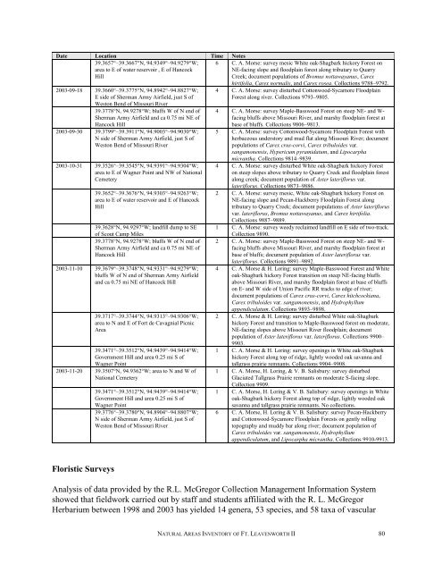
Floristic Surveys<br />
39.3471°–39.3512°N, 94.9439°–94.9414°W;<br />
Government Hill and area 0.25 mi S <strong>of</strong><br />
Wagner Point<br />
39.3776°–39.3780°N, 94.8904°–94.8807°W;<br />
N side <strong>of</strong> Sherman Army Airfield, just S <strong>of</strong><br />
Weston Bend <strong>of</strong> Missouri River<br />
6 C. A. Morse: survey mesic White oak-Shagbark hickory Forest on<br />
NE-facing slope and floodplain forest along tributary to Quarry<br />
Creek; document populations <strong>of</strong> Bromus nottawayanus, Carex<br />
hirtifolia, Carex normalis, and Carex rosea. Collections 9788–9792.<br />
4 C. A. Morse: survey disturbed Cottonwood-Sycamore Floodplain<br />
Forest along river. Collections 9793–9805.<br />
4 C. A. Morse: survey Maple-Basswood Forest on steep NE- and Wfacing<br />
bluffs above Missouri River, and marshy floodplain forest at<br />
base <strong>of</strong> bluffs. Collections 9806–9813.<br />
5 C. A. Morse: survey Cottonwood-Sycamore Floodplain Forest with<br />
herbaceous understory and mud flat along Missouri River; document<br />
populations <strong>of</strong> Carex crus-corvi, Carex tribuloides var.<br />
sangamonensis, Hypericum pyramidatum, and Lipocarpha<br />
micrantha. Collections 9814–9839.<br />
4 C. A. Morse: survey disturbed White oak-Shagbark hickory Forest<br />
on steep slopes above tributary to Quarry Creek and floodplain forest<br />
along creek; document population <strong>of</strong> Aster lateriflorus var.<br />
lateriflorus. Collections 9873–9886.<br />
2 C. A. Morse: survey mesic, White oak-Shagbark hickory Forest on<br />
NE-facing slope and Pecan-Hackberry Floodplain Forest along<br />
tributary to Quarry Creek; document populations <strong>of</strong> Aster lateriflorus<br />
var. lateriflorus, Bromus nottawayanus, and Carex hirtifolia.<br />
Collections 9887–9889.<br />
1 C. A. Morse: survey weedy reclaimed landfill on E side <strong>of</strong> two-track.<br />
Collection 9890.<br />
2 C. A. Morse: survey Maple-Basswood Forest on steep NE- and Wfacing<br />
bluffs above Missouri River, and marshy floodplain forest at<br />
base <strong>of</strong> bluffs; document population <strong>of</strong> Aster lateriflorus var.<br />
lateriflorus. Collections 9891–9892.<br />
4 C. A. Morse & H. Loring: survey Maple-Basswood Forest and White<br />
oak-Shagbark hickory Forest transition on steep NE-facing bluffs<br />
above Missouri River, and marshy floodplain forest at base <strong>of</strong> bluffs<br />
on E- and W side <strong>of</strong> Union Pacific RR tracks to edge <strong>of</strong> river;<br />
document populations <strong>of</strong> Carex crus-corvi, Carex hitchcockiana,<br />
Carex tribuloides var. sangamonensis, and Hydrophyllum<br />
appendiculatum. Collections 9893–9898.<br />
2 C. A. Morse & H. Loring: survey disturbed White oak-Shagbark<br />
hickory Forest and transition to Maple-Basswood forest on moderate,<br />
NE-facing slopes above Missouri River floodplain; document<br />
population <strong>of</strong> Aster lateriflorus var. lateriflorus. Collections 9900–<br />
9903.<br />
1 C. A. Morse & H. Loring: survey openings in White oak-Shagbark<br />
hickory Forest along top <strong>of</strong> ridge, lightly wooded oak savanna and<br />
tallgrass prairie remnants. Collections 9904–9908.<br />
1 C. A. Morse, H. Loring, & V. B. Salisbury: survey disturbed<br />
Glaciated Tallgrass Prairie remnants on moderate S-facing slope.<br />
Collection 9909.<br />
1 C. A. Morse, H. Loring & V. B. Salisbury: survey openings in White<br />
oak-Shagbark hickory Forest along top <strong>of</strong> ridge, lightly wooded oak<br />
savanna and tallgrass prairie remnants. No collections.<br />
6 C. A. Morse, H. Loring & V. B. Salisbury: survey Pecan-Hackberry<br />
and Cottonwood-Sycamore Floodplain Forests on gently rolling<br />
topography and muddy bar along river; document population <strong>of</strong><br />
Carex tribuloides var. sangamonensis, Hydrophyllum<br />
appendiculatum, and Lipocarpha micrantha. Collections 9910-9913.<br />
Analysis <strong>of</strong> data provided by <strong>the</strong> R.L. McGregor Collection Management Information System<br />
showed that fieldwork carried out by staff and students affiliated with <strong>the</strong> R. L. McGregor<br />
Herbarium between 1998 and 2003 has yielded 14 genera, 53 species, and 58 taxa <strong>of</strong> vascular<br />
NATURAL AREAS INVENTORY OF FT. LEAVENWORTH II 80