Livelihood Security: Climate change, conflict and migration in - UNEP
Livelihood Security: Climate change, conflict and migration in - UNEP
Livelihood Security: Climate change, conflict and migration in - UNEP

You also want an ePaper? Increase the reach of your titles
YUMPU automatically turns print PDFs into web optimized ePapers that Google loves.
erde<br />
de<br />
25°0'N<br />
20°0'N<br />
15°0'N<br />
10°0'N<br />
5°0'N<br />
0°0'<br />
Dakar<br />
Map Canary Isl<strong>and</strong>s 5. Conflict occurrences<br />
Sa<strong>in</strong>t-Louis !<br />
T h e<br />
G a m b i a<br />
Nouakchott<br />
" !<br />
!<br />
!<br />
!<br />
!<br />
!<br />
!<br />
!<br />
! ! !<br />
"<br />
!<br />
"<br />
!<br />
" !<br />
!<br />
" !<br />
!<br />
"<br />
!<br />
! Thies<br />
"<br />
Diourbel<br />
Kayes<br />
Mopti<br />
Mbour Kaolack<br />
Z<strong>in</strong>der<br />
Serre Kunda<br />
Niamey<br />
Banjul<br />
Ségou<br />
Maradi<br />
!<br />
"<br />
Sokoto<br />
Bamako<br />
Zigu<strong>in</strong>chor<br />
Kats<strong>in</strong>a<br />
"<br />
Ouagadougou<br />
"<br />
Gusau<br />
Bissau<br />
Kano<br />
!<br />
G u i n e a -<br />
B i s s a u<br />
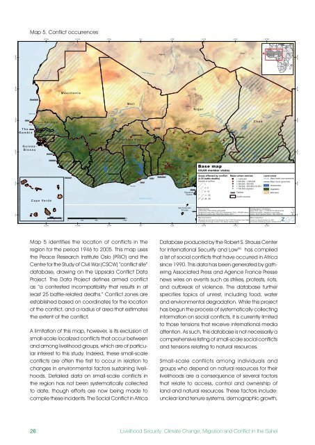
Map 5 identifies the location of <strong>conflict</strong>s <strong>in</strong> the<br />
region for the period 1946 to 2005. This map uses<br />
the Peace Research Institute Oslo (PRIO) <strong>and</strong> the<br />
Centre for the Study of Civil War (CSCW) “<strong>conflict</strong> site”<br />
database, draw<strong>in</strong>g on the Uppsala Conflict Data<br />
Project. The Data Project def<strong>in</strong>es armed <strong>conflict</strong><br />
as “a contested <strong>in</strong>compatibility that results <strong>in</strong> at<br />
least 25 battle-related deaths.” Conflict zones are<br />
established based on coord<strong>in</strong>ates for the location<br />
of the <strong>conflict</strong>, <strong>and</strong> a radius of area that estimates<br />
the extent of the <strong>conflict</strong>.<br />
A limitation of this map, however, is its exclusion of<br />
small-scale localized <strong>conflict</strong>s that occur between<br />
<strong>and</strong> among livelihood groups, which are of particular<br />
<strong>in</strong>terest to this study. Indeed, these small-scale<br />
<strong>conflict</strong>s are often the first to occur <strong>in</strong> relation to<br />
<strong>change</strong>s <strong>in</strong> environmental factors susta<strong>in</strong><strong>in</strong>g livelihoods.<br />
Detailed data on small-scale <strong>conflict</strong>s <strong>in</strong><br />
the region has not been systematically collected<br />
to date, though efforts are now be<strong>in</strong>g made to<br />
compile these <strong>in</strong>cidents. The Social Conflict <strong>in</strong> Africa<br />
26<br />
" !<br />
15°0'W<br />
W a d i Khatt Atoui<br />
S e n e g a l<br />
15°0'W<br />
Saloum<br />
Conakry<br />
C a p e V e r d e<br />
Gambia<br />
" !<br />
Freetown<br />
S e neg a l<br />
" !<br />
!<br />
Praia Scale: 1:7,000,000<br />
0 50<br />
km<br />
100<br />
M a u r i t a n i a<br />
Gu<strong>in</strong>ea<br />
Sierra Leone<br />
Sewa<br />
Ba f <strong>in</strong> g<br />
Monrovia<br />
" !<br />
Niger<br />
Agadir<br />
10°0'W<br />
B akoy<br />
Liberia<br />
Safi<br />
Marrakesh<br />
Nuo n<br />
Cavally<br />
Sass<strong>and</strong>ra<br />
Morocco<br />
Bani<br />
Sikasso<br />
!<br />
B<strong>and</strong>ama Blanc<br />
5°0'W<br />
Côte d'Ivoire<br />
B lack Volta<br />
Bobo Dioulasso<br />
!<br />
Komoe<br />
Niger<br />
0 250<br />
500<br />
km<br />
1.000<br />
10°0'W<br />
Black Volta<br />
M a l i<br />
White Volta<br />
B u r k i n a F a s o<br />
!<br />
Tamale<br />
Wadi Tamanrasset<br />
Niger<br />
Vallée de l'Azaouak<br />
Arlit<br />
!<br />
Agadez<br />
!<br />
Kaduna<br />
"<br />
Jos<br />
"<br />
M<strong>in</strong>na<br />
!<br />
Abuja<br />
!<br />
Bouaké<br />
"<br />
Koss ou<br />
Res ervoir<br />
!<br />
Yamoussoukro<br />
Abidjan<br />
"<br />
Ghana<br />
La ke<br />
Kumasi<br />
Volta<br />
"<br />
Ashiaman<br />
!<br />
" !<br />
Accra<br />
!<br />
Takoradi<br />
"<br />
Isey<strong>in</strong> !<br />
Oshogbo<br />
Makurdi<br />
" Ede "<br />
!<br />
! " Ado Okene<br />
! ! !<br />
!<br />
Iwo<br />
"<br />
Abomey<br />
" !<br />
Ibadan<br />
Ife<br />
! Ilesha Akure<br />
! !<br />
"<br />
!<br />
!<br />
Ikire<br />
Abeokuta<br />
Owo<br />
Cotonou Lagos<br />
Ondo<br />
! Ikorodu<br />
Enugu<br />
!<br />
"<br />
"<br />
"<br />
" Ben<strong>in</strong><br />
" !<br />
"<br />
Porto-Novo<br />
Onitsha<br />
Bamenda<br />
Lomé<br />
!<br />
Warri Umuahia<br />
" !<br />
!<br />
Aba Ikot Ekpene<br />
" !<br />
Bafoussam<br />
Port Harcourt<br />
"<br />
" Calabar<br />
1<br />
Douala<br />
B<strong>and</strong>ama<br />
La ke<br />
Fa guib<strong>in</strong>e<br />
5°0'W<br />
Red Volta<br />
0°0'<br />
0°0'<br />
Vallée d u Tilemsi<br />
Oti<br />
Volta<br />
Togo<br />
Atlantic Ocean<br />
Ben<strong>in</strong><br />
Algeria<br />
W a di Bosso<br />
Ogbomosho<br />
5°0'E<br />
Wadi Irharrhar<br />
Wad i Tam anrasset<br />
Ka<strong>in</strong>ji<br />
La ke<br />
5°0'E<br />
Niger<br />
Zaria<br />
"<br />
Nigeria<br />
Cross<br />
Equatorial<br />
Gu<strong>in</strong>ea<br />
Sao Tome <strong>and</strong><br />
Pr<strong>in</strong>cipe<br />
Malabo<br />
Tunisia<br />
!<br />
Wadi Tafassasset<br />
N i g e r<br />
Katsi n a Ala<br />
Wadi Tegouma<br />
Conflict data: PRIO-CSCW (1970-2005)<br />
Scale (ma<strong>in</strong> map): 1:17,000,000 for DIN A4 pr<strong>in</strong>ts<br />
" ! Background vector data: ESRI; FAO GeoNetwork; GAUL; GRUMP (alpha) Reference system: Geographic coord<strong>in</strong>ates<br />
Background satellite data: NASA Blue Marble (2001)<br />
Datum: World Geodetic System 1984 (WGS 84)<br />
Database produced by the Robert S. Strauss Center<br />
for International <strong>Security</strong> <strong>and</strong> Law90 K<strong>in</strong>shasa<br />
K<strong>in</strong>shasa<br />
Brazzaville<br />
Po<strong>in</strong>te Noire<br />
Cab<strong>in</strong>da<br />
Boma has compiled<br />
a list of social <strong>conflict</strong>s that have occurred <strong>in</strong> Africa<br />
s<strong>in</strong>ce 1990. This data has been generated by gather<strong>in</strong>g<br />
Associated Press <strong>and</strong> Agence France Presse<br />
news wires on events such as strikes, protests, riots,<br />
<strong>and</strong> outbreak of violence. The database further<br />
specifies topics of unrest, <strong>in</strong>clud<strong>in</strong>g food, water<br />
<strong>and</strong> environmental degradation. While this project<br />
has begun the process of systematically collect<strong>in</strong>g<br />
<strong>in</strong>formation on social <strong>conflict</strong>s, it is currently limited<br />
to those tensions that receive <strong>in</strong>ternational media<br />
attention. As such, this database is not necessarily a<br />
comprehensive list<strong>in</strong>g of small-scale social <strong>conflict</strong>s<br />
<strong>and</strong> tensions relat<strong>in</strong>g to natural resources.<br />
Small-scale <strong>conflict</strong>s among <strong>in</strong>dividuals <strong>and</strong><br />
groups who depend on natural resources for their<br />
livelihoods are a consequence of several factors<br />
that relate to access, control <strong>and</strong> ownership of<br />
l<strong>and</strong> <strong>and</strong> natural resources. These factors <strong>in</strong>clude:<br />
unclear l<strong>and</strong> tenure systems, demographic growth,<br />
<strong>Livelihood</strong> <strong>Security</strong>: <strong>Climate</strong> Change, Migration <strong>and</strong> Conflict <strong>in</strong> the Sahel<br />
10°0'E<br />
Bauchi<br />
!<br />
"<br />
Ogooué<br />
B enue<br />
Sanaga<br />
Equatorial<br />
Gu<strong>in</strong>ea<br />
!<br />
Damaturu<br />
Gombe Mubi<br />
!<br />
!<br />
" !<br />
6 - 10<br />
Yaoundé<br />
11 - 25<br />
Wadi Dillia<br />
Komadugu Gana<br />
!<br />
Jimeta<br />
Base map<br />
Sanaga<br />
"<br />
Maiduguri<br />
Garoua<br />
"<br />
Cameroon<br />
Ngaoundéré<br />
!<br />
Iv <strong>in</strong> d o<br />
Tripoli<br />
D ja<br />
" !<br />
!<br />
Maroua<br />
Libya<br />
Moundou<br />
!<br />
Bahr el Ghazal<br />
Bahr Salamat<br />
Sarh<br />
!<br />
" > 1,000,000<br />
" > 500,000 - 1,000,000<br />
! > 250,000 - 500,000<br />
Bertoua<br />
! ! > 100,000 - 250,000 (CILSS)<br />
Bangui<br />
" !<br />
Bangui<br />
! < 100,000 (capitals)<br />
Congo<br />
C h a d<br />
Wa di Te li Basal<br />
Wadi H aw ach<br />
Central African Republic<br />
Map description:<br />
Map production:<br />
Gabon<br />
Map gives an overview of the location of the CILSS (Permanent Inter-State Centre for Geo<strong>in</strong>formatics (Z_GIS),<br />
Committee for Drought Control <strong>in</strong> the Sahel) member states.<br />
University of Salzburg, Austria, October 2010<br />
O gooue<br />
al-Aziziyah<br />
CILSS member states<br />
Dja<br />
Misratah<br />
N'Djamena<br />
Ngoko<br />
Alim a<br />
Congo<br />
Sang h a<br />
Oubangui (Ubangi)<br />
Giri<br />
Congo<br />
Giri<br />
Giri<br />
Congo Congo<br />
Congo<br />
Congo<br />
Ikele m b a<br />
Ruki<br />
Benghazi<br />
C ongo<br />
Lulonga<br />
Oubangui (Ubangi)<br />
Data sources: Cartographic <strong>in</strong>formation:<br />
Libreville<br />
10°0'E<br />
Iv<strong>in</strong>do<br />
15°0'E<br />
La ke<br />
Chad<br />
Alima<br />
15°0'E<br />
Ch a ri<br />
Logone<br />
Areas affected by <strong>conflict</strong> Major urban centres<br />
(≥ 25 battle deaths)<br />
Number of <strong>conflict</strong>s<br />
2 - 5<br />
26 - 55<br />
Dakar Capitals<br />
CILSS countries<br />
Sang h a<br />
Congo<br />
O uham<br />
20°0'E<br />
L<strong>and</strong> cover<br />
Major wadis (non-perennial)<br />
B usira<br />
20°0'E<br />
Congo<br />
Lopori<br />
Mar<strong>in</strong>ga<br />
Major rivers (perennial)<br />
Waterbodies<br />
Vegetation<br />
Bare l<strong>and</strong><br />
Congo<br />
Salon ga<br />
Bolombo<br />
Yekokora<br />
Tshuapa<br />
Lomela<br />
Salonga<br />
Kananga<br />
Itimb iri<br />
Mar<strong>in</strong>ga<br />
Tshuapa<br />
Lomela<br />
Zaire<br />
Itimbiri<br />
Congo<br />
Mbuji-Mayi<br />
´<br />
Congo<br />
25°0'N<br />
20°0'N<br />
15°0'N<br />
"<br />
10°0'N<br />
5°0'N<br />
U ele<br />
0°0'<br />
ad-Duayn