Livelihood Security: Climate change, conflict and migration in - UNEP
Livelihood Security: Climate change, conflict and migration in - UNEP
Livelihood Security: Climate change, conflict and migration in - UNEP

Create successful ePaper yourself
Turn your PDF publications into a flip-book with our unique Google optimized e-Paper software.
Dakar<br />
T h e<br />
a m b i a<br />
Nouakchott<br />
Banjul<br />
G u i n e a -<br />
B i s s a u<br />
15°0'W<br />
S e n e g a l<br />
Bissau<br />
15°0'W<br />
Conakry<br />
Freetown<br />
M a u r i t a n i a<br />
Gu<strong>in</strong>ea<br />
Sierra Leone<br />
Monrovia<br />
10°0'W<br />
Liberia<br />
10°0'W<br />
Bamako<br />
Côte d'Ivoire<br />
St. Helena<br />
Yamoussoukro<br />
M a l i<br />
Ouagadougou<br />
B u r k i n a F a s o<br />
Ghana<br />
<strong>Livelihood</strong> <strong>Security</strong>: <strong>Climate</strong> Change, Migration <strong>and</strong> Conflict <strong>in</strong> the Sahel<br />
5°0'W<br />
5°0'W<br />
0°0'<br />
Accra<br />
0°0'<br />
Map production: Niamey<br />
Centre for Geo<strong>in</strong>formatics (Z_GIS),<br />
University of Salzburg, Austria, October 2010<br />
Togo<br />
Atlantic Ocean<br />
Lomé<br />
Ben<strong>in</strong><br />
Porto-Novo<br />
5°0'E<br />
5°0'E<br />
Nigeria<br />
Malabo<br />
Equatorial<br />
Gu<strong>in</strong>ea<br />
Sao Tome <strong>and</strong><br />
Pr<strong>in</strong>cipe<br />
"<br />
! !<br />
! !<br />
! !<br />
Okene<br />
Ibadan Ife Efon Alaye<br />
"<br />
Ibadan<br />
!<br />
! " ! ! Ikire ! ! ! ! ! ! ! ! ! ! ! !<br />
!<br />
Akure<br />
!<br />
_<br />
! ! Abomey ! ! ! " ! ! ! ! ! ! ! ! !<br />
! !<br />
Lake<br />
Abeokuta<br />
Akure<br />
!<br />
Owo<br />
Volta<br />
Ondo<br />
_<br />
! ! ! ! ! ! ! ! ! ! ! ! ! !<br />
Togo Ben<strong>in</strong> Nigeria<br />
! _<br />
! ! ! !<br />
! ! ! ! ! Ikorodu ! ! ! ! ! ! ! ! !<br />
!<br />
Lagos Enugu<br />
! ! ! ! ! ! ! ! ! ! ! ! ! ! ! !<br />
Cotonou<br />
"<br />
Ben<strong>in</strong><br />
! ! ! ! ! ! ! ! ! ! ! !<br />
"<br />
Lake Volta<br />
! ! ! ! ! ! ! ! ! ! ! ! ! ! ! ! ! ! ! ! ! ! ! ! ! ! ! !<br />
! ! ! ! ! ! ! ! ! ! ! ! ! ! ! ! ! ! ! ! ! ! ! ! ! ! ! ! ! !<br />
! ! ! ! !<br />
! ! ! ! ! ! ! ! ! ! ! ! ! ! ! ! ! ! ! ! ! ! ! ! !<br />
si<br />
! ! ! ! ! ! ! ! ! ! ! ! ! ! ! ! ! ! ! ! ! ! ! !<br />
! ! ! ! ! ! ! ! ! ! ! ! ! ! ! ! ! !<br />
"<br />
"<br />
! ! ! ! ! ! ! ! ! ! ! ! !<br />
! ! !<br />
"<br />
Porto-Novo<br />
! ! ! ! ! ! ! ! ! ! Onitsha ! !<br />
"<br />
! ! ! ! !<br />
ana<br />
! !<br />
!<br />
!<br />
!<br />
!<br />
!<br />
! Ashiaman !<br />
!<br />
! "<br />
!<br />
! Lomé<br />
!<br />
!<br />
! !<br />
! ! !<br />
Warri<br />
! " ! !<br />
!<br />
!<br />
!<br />
!<br />
!<br />
!<br />
!<br />
!<br />
!<br />
!<br />
!<br />
!<br />
!<br />
!<br />
! ! !<br />
! ! !<br />
Umuahia<br />
! ! !<br />
!<br />
!<br />
!<br />
!<br />
!<br />
!<br />
i<br />
! ! Accra<br />
! !<br />
!<br />
!<br />
!<br />
!<br />
!<br />
!<br />
!<br />
!<br />
! ! ! !<br />
! ! ! !<br />
! Port ! Harcourt ! !<br />
"<br />
! !<br />
Ikot Ekpene<br />
!<br />
!<br />
" ! ! !<br />
Aba<br />
! ! !<br />
!<br />
!<br />
!<br />
!<br />
!<br />
!<br />
Calabar !<br />
"<br />
! !<br />
! ! ! ! ! ! ! ! ! ! ! !<br />
Volta<br />
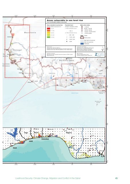
Areas vulnerable to sea level rise<br />
0 to 5 m elevation relative to sea level<br />
Areas vulnerable to sea level rise<br />
Elevation relative to sea level (<strong>in</strong> m)<br />
-5 - 1 m<br />
> 1 - 2 m<br />
> 2- 3 m<br />
> 3 - 4 m<br />
> 4 - 5 m<br />
Population trend<br />
Changes <strong>in</strong> population numbers<br />
[< -500] not represented <strong>in</strong> the map<br />
_ > -500 - 0<br />
[0 - 500] not represented <strong>in</strong> the map<br />
! > 500 - 1,000<br />
! > 1,000 - 2,500<br />
! > 2,500 - 5,000<br />
! > 5,000<br />
Data sources:<br />
Elevation data: CGIAR-CSI (SRTM v4)<br />
Population data: African Population Database (1970-2000); GPWv3 (2010)<br />
Background vector data: ESRI; FAO GeoNetwork; GAUL; GRUMP (alpha)<br />
Def<strong>in</strong>ition of <strong>in</strong>dicator:<br />
Map shows the areas vulnerable to sea level rise based on SRTM v4 global<br />
digital elevation data.<br />
Major urban centres<br />
! ! ! ! ! ! ! ! ! ! ! ! ! !<br />
! !<br />
! ! ! ! ! ! ! ! !<br />
Niger<br />
" > 1,000,000<br />
Cartographic <strong>in</strong>formation:<br />
Scale (ma<strong>in</strong> map): 1:15,000,000 for DIN A3 pr<strong>in</strong>ts<br />
Scale (<strong>in</strong>serts): 1:5,500,000 for DIN A3 pr<strong>in</strong>ts<br />
Reference system: Geographic coord<strong>in</strong>ates<br />
Datum: World Geodetic System 1984 (WGS 84)<br />
! ! ! ! !<br />
" 500,000 - 1,000,000<br />
! > 250,000 - 500,000<br />
!<br />
!<br />
Dakar Capitals<br />
> 100,000 - 2,50,000 (CILSS)<br />
< 100,000 (capitals)<br />
CILSS countries<br />
Major wadis (non-perennial)<br />
Major rivers (perennial)<br />
Waterbodies<br />
!<br />
Cross<br />
´<br />
Abuja<br />
20°0'N<br />
N i g e r<br />
! ! ! !<br />
Malabo<br />
!<br />
!<br />
15°0'N<br />
10°0'N<br />
5°0'N<br />
0°0'<br />
5°0'S<br />
!<br />
! !<br />
10°0'S<br />
_<br />
!<br />
!<br />
15°0'S<br />
Equatorial<br />
Gu<strong>in</strong>ea<br />
Kats <strong>in</strong>a Ala<br />
Cameroon<br />
45