Growth of Scarborough Study - Scarborough Borough Council
Growth of Scarborough Study - Scarborough Borough Council
Growth of Scarborough Study - Scarborough Borough Council

You also want an ePaper? Increase the reach of your titles
YUMPU automatically turns print PDFs into web optimized ePapers that Google loves.
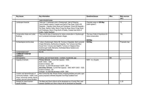
Key issues Key information Questions/issues Who Main sources<br />
(ref.)<br />
Large industrial areas<br />
Landscape character<br />
Conservation Areas and Listed<br />
Buildings<br />
There are 11 landscape units in <strong>Scarborough</strong>: Vale <strong>of</strong> Pickering,<br />
Carrs+Coastal Lowland, Coastal Land East <strong>of</strong> Filey Road, Oliver’s Mt<br />
Deepdale – Osgodby Scarp Slope and Footslopes, Olivers Mt Deepdale –<br />
Dip Slope, Seamer Valley, Moors Fringe Dip Slope, Moors Fringe Scarp<br />
and Footslopes, Moors Fringe North <strong>of</strong> Scalby, Coastal Area North <strong>of</strong><br />
Scalby, Castle Headland<br />
There are 64 sites <strong>of</strong> importance for nature conservation in <strong>Scarborough</strong><br />
and 4 protected landscapes between villages<br />
Archaeological priority areas 7 sites in <strong>Scarborough</strong>, Holme Hill, Tumulus in Deepdale, Saint Leonards<br />
Chapel (Remains), Earthworks at Osgodby, Two Tumulus near Moor<br />
House Farm, Tumulus near Edgehill, Tumulus on Falsgrave Moor,<br />
<strong>Scarborough</strong> Castle (Remains), Northstead Manor Gardens and<br />
Northstead Waterfalls.<br />
Contaminated land? No info<br />
COMMUNITY/VISITOR<br />
CAPACITY<br />
Character areas on GIS Map<br />
(traffic lighted?)<br />
15a map <strong>of</strong> sites <strong>of</strong> importance for<br />
nature conservation<br />
GIS Map<br />
GIS Map Proposals map<br />
Demographics Existing, past and future trends – numbers, households, age KM<br />
Capacity <strong>of</strong> schools Primary Schools - Current Net Capacity – 4494,<br />
NOR 1/2003 – 4288.<br />
Surplus <strong>of</strong> places - 206<br />
Forecast – by 2007/08 decrease in NOR – 3974<br />
Secondary Schools - Current Net Capacity – 3650, NOR 1/2003 – 3525,<br />
Surplus <strong>of</strong> places - 125<br />
Forecast – by 2007/08 decrease in NOR - 3363<br />
NOR – no. <strong>of</strong> pupils 9<br />
Location and demand/supply <strong>of</strong><br />
community facilities – health, local<br />
shops, community centres, leisure<br />
centres, arts and cultural facilities<br />
Similarly for resort/ tourism<br />
specific facilities<br />
New Community Hall, Primary School, shopping facilities and public open<br />
space proposed at Middle Deepdale Farm/High Eastfield Farm<br />
The Mere and Oliver’s Mount will be developed as a Country Park, land<br />
between Eastfield and Oliver’s Mount will be developed as Deepdale<br />
13<br />
15a<br />
3<br />
3, 20