- Page 1 and 2: Southwest Florida Water Management
- Page 3 and 4: Upper Coastal Drainage.............
- Page 5 and 6: INTRODUCTION The Florida Department
- Page 7 and 8: An analysis of selected mitigation
- Page 9 and 10: Charlotte Harbor Drainage Project:
- Page 11 and 12: Mitigation: Colt Creek State Park (
- Page 13 and 14: Status: No revisions, permitted Lit
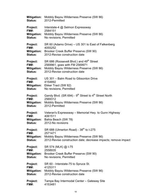
- Page 15 and 16: Project: SR 40 - CR 328 to SW 80th
- Page 17 and 18: FM# 1976791 Mitigation: Peace - Cir
- Page 19 and 20: Mitigation: Curry Creek Regional Mi
- Page 21: FM#: 2555991 Mitigation: Cockroach
- Page 25 and 26: Mitigation: Anclote Parcel (SW54) S
- Page 27 and 28: Mitigation: Conner Preserve (SW 77)
- Page 29 and 30: Project: SR 200 - US 41 to Marion C
- Page 31 and 32: flexibility to evaluate a mitigatio
- Page 33 and 34: Status: Phase 1 construction-initia
- Page 35 and 36: Status: Preservation - 198 acres To
- Page 37 and 38: Description: Marsh (Salt) Creation
- Page 39 and 40: Project: Ft. DeSoto Park ID#: SW 70
- Page 41 and 42: REGIONAL MITIGATION PLAN BACKGROUND
- Page 43 and 44: F. Brief explanation of why a SWIM
- Page 45 and 46: Bursera simaruba gumbo limbo UPL Ch
- Page 47 and 48: Port Charlotte El Jobean SR 776 - E
- Page 49 and 50: Myakka River Project Limits - Phase
- Page 51 and 52: REGIONAL MITIGATION PLAN BACKGROUND
- Page 53 and 54: Hollomans Branch Hollom ans Branch
- Page 55 and 56: Berm Breach, Outfall to Lake Lakesh
- Page 57 and 58: REGIONAL MITIGATION PLAN BACKGROUND
- Page 59 and 60: Construction & Planting $1,336,000
- Page 61 and 62: Gateway - Observed Wildlife Species
- Page 64 and 65: Tampa Bay North Scale - 2000 ft. Ho
- Page 66 and 67: North Scale - 2000 ft. Ulmerton Roa
- Page 68 and 69: South Tract (2003) - pre-constructi
- Page 70 and 71: North Tract (2009) - improved tidal
- Page 72 and 73:
Gateway was the first restoration p
- Page 74 and 75:
REGIONAL MITIGATION PLAN BACKGROUND
- Page 76 and 77:
Project cost: $650,000 (total) Incl
- Page 78 and 79:
FFWCC - Tenoroc Property Boundary P
- Page 80 and 81:
FFWCC - Tenoroc Property Boundary O
- Page 82 and 83:
REGIONAL MITIGATION PLAN BACKGROUND
- Page 84 and 85:
CR 54 Loughman US Hwy. 17 17 < To D
- Page 86 and 87:
E. Brief explanation of why a mitig
- Page 88 and 89:
SW 50 - Terra Ceia Restoration Figu
- Page 90 and 91:
Pre-Construction (1999) - wetlands
- Page 92 and 93:
REGIONAL MITIGATION PLAN BACKGROUND
- Page 94 and 95:
Second Phase Construction - 2006-20
- Page 96 and 97:
SW 51 - Myakka River State Park Fig
- Page 98 and 99:
The eradication of exotic species i
- Page 104 and 105:
100
- Page 106 and 107:
102
- Page 108 and 109:
104
- Page 110 and 111:
egeneration of marsh and wet prairi
- Page 112 and 113:
108
- Page 114 and 115:
Restored Upland Habitat Created For
- Page 116 and 117:
cypress-dominated wetland creation
- Page 118 and 119:
02 25 16 11 25 16 14 25 16 Little R
- Page 120 and 121:
116
- Page 122 and 123:
REGIONAL MITIGATION PLAN BACKGROUND
- Page 124 and 125:
Construction & Planting $128,000 Ma
- Page 126 and 127:
98 Mixed Forested Wetlands Hydrolog
- Page 128 and 129:
Spring, 2001 - view of the 1.3 mile
- Page 130 and 131:
Summer, 2000 - along with bisecting
- Page 132 and 133:
Summer, 2000 - prior to constructio
- Page 134 and 135:
C. Brief description of conducted w
- Page 136 and 137:
groundwater evaluation for the Cock
- Page 138 and 139:
Tampa Bay Hillsborough County ELAPP
- Page 140 and 141:
Wetland Creation & Selmon Expresswa
- Page 142 and 143:
Wetland Creation & Selmon Expresswa
- Page 144 and 145:
Current Post--Construction (2009) -
- Page 146 and 147:
impacts and location match the habi
- Page 148 and 149:
View of the barge used to hydraulic
- Page 150 and 151:
documented in the marsh and adjacen
- Page 152 and 153:
148
- Page 154 and 155:
150
- Page 156 and 157:
152
- Page 158 and 159:
the perimeter of the forested wetla
- Page 160 and 161:
ATTACHMENT A - Hampton Tract - Exis
- Page 162 and 163:
habitat, however it is anticipated
- Page 164 and 165:
Green Swamp Wilderness Preserve (We
- Page 166 and 167:
REGIONAL MITIGATION PLAN BACKGROUND
- Page 168 and 169:
Timeframe for implementation: Comme
- Page 170 and 171:
Success criteria requirements inclu
- Page 172 and 173:
County Line Road Hillsborough Count
- Page 174 and 175:
170
- Page 176 and 177:
REGIONAL MITIGATION PLAN BACKGROUND
- Page 178 and 179:
Project cost: $460,000 (total) Desi
- Page 180 and 181:
92 600 Gandy Bridge Tampa Bay 587 0
- Page 182 and 183:
Tampa Bay 100 50 0 100 Feet Decreas
- Page 184 and 185:
During 2003 construction of the nor
- Page 186 and 187:
Some fill material removal and the
- Page 188 and 189:
only SWIM-sponsored project within
- Page 190 and 191:
186
- Page 192 and 193:
REGIONAL MITIGATION PLAN BACKGROUND
- Page 194 and 195:
E. Brief explanation of why a mitig
- Page 196 and 197:
469 SR 50 To Clermont > Tarrytown S
- Page 198 and 199:
FDOT MITIGATION SITE (Withlacoochee
- Page 200 and 201:
and planting activities were conduc
- Page 202 and 203:
The SWFWMD discontinued the row cro
- Page 204 and 205:
There are five wetlands that had up
- Page 206 and 207:
criteria required 90% survivorship
- Page 208 and 209:
204
- Page 210 and 211:
Property Boundary W15 W1 W6 W5 W4 W
- Page 212 and 213:
Wetland 12 (2001) - Pre-constructio
- Page 214 and 215:
Wetland 6 (2001) - Pre-construction
- Page 216 and 217:
REGIONAL MITIGATION PLAN BACKGROUND
- Page 218 and 219:
areas were further restored with th
- Page 220 and 221:
3. Location map and design drawings
- Page 222 and 223:
myrtle (Myrica cerifera) in the hig
- Page 224 and 225:
Lakeland ST 33A £¤ 98 GH 570 Polk
- Page 226 and 227:
Treatment Marsh Creation & Upland B
- Page 228 and 229:
Western Wetland Restoration (2006)
- Page 230 and 231:
Center Wetland Restoration (2005) -
- Page 232 and 233:
Center Wetland Restoration (2009) -
- Page 234 and 235:
Eastern Wetland Restoration (2006)
- Page 236 and 237:
Wildlife - substantial populations
- Page 238 and 239:
REGIONAL MITIGATION PLAN BACKGROUND
- Page 240 and 241:
ATTACHMENTS 1. Description of pre-p
- Page 242 and 243:
238
- Page 244 and 245:
Tampa Bay TECO Power Plant 672 672
- Page 246 and 247:
Dunes Project Boundary Inter-ti dal
- Page 248 and 249:
Current Post-Construction Condition
- Page 250 and 251:
the dense, high quality mangrove co
- Page 252 and 253:
248
- Page 254 and 255:
250
- Page 256 and 257:
252
- Page 258 and 259:
254
- Page 260 and 261:
REGIONAL MITIGATION PLAN BACKGROUND
- Page 262 and 263:
Proposed timeframe for implementati
- Page 264 and 265:
0.25 0.125 0 0.25 Miles Pinellas Ba
- Page 266 and 267:
Ft. DeSoto Park - Historic Conditio
- Page 268 and 269:
Bridge Construction & Channel Dredg
- Page 270 and 271:
Ft. DeSoto Park Ecosystem Restorati
- Page 272 and 273:
part of the Preserve. Prior to enha
- Page 274 and 275:
Attachment A - Site Conditions and
- Page 276 and 277:
St. Petersburg 19 Lake Maggiore Big
- Page 278 and 279:
REGIONAL MITIGATION PLAN BACKGROUND
- Page 280 and 281:
MITIGATION PROJECT IMPLEMENTATION E
- Page 282 and 283:
Project Site 4 - This remnant tram
- Page 284 and 285:
15 25 17 22 25 17 14 25 17 1,250 62
- Page 286 and 287:
Pre-Construction - Site 4 (2005) -
- Page 288 and 289:
Pre-Construction - Site 8 (2005) -
- Page 290 and 291:
C. Brief description of conducted w
- Page 292 and 293:
activities will continue to be cond
- Page 294 and 295:
Tidal Lagoon, Salt-Marsh, Saltern &
- Page 296 and 297:
During Construction (2005) - view f
- Page 298 and 299:
Current Conditions (2009) - view fr
- Page 300 and 301:
Other common species include smartw
- Page 302 and 303:
Attachment A - Existing and Propose
- Page 304 and 305:
13 26 25 18 26 26 16 26 26 15 26 26
- Page 306 and 307:
REGIONAL MITIGATION PLAN BACKGROUND
- Page 308 and 309:
of hardwoods and myrtles within the
- Page 310 and 311:
ATTACHMENTS 1. Description of exist
- Page 312 and 313:
SR 52 Property Boundary (Yellow) Fo
- Page 314 and 315:
Table of Contents INTRODUCTION.....
- Page 316 and 317:
Figure 1. Conner Preserve Location
- Page 318 and 319:
Florida Department of Transportatio
- Page 320 and 321:
Pine flatwoods - The intact pine fl
- Page 322 and 323:
Gopher tortoises (Gopherus polyphem
- Page 324 and 325:
y trees and shrubs, such as willows
- Page 326 and 327:
Figure 4 (Cont.). Conner Preserve L
- Page 328 and 329:
RESTORATION PLAN Restoration Method
- Page 330 and 331:
Site 2 Consists of 50-acres located
- Page 332 and 333:
elevations, which once supported pi
- Page 334 and 335:
Figure 11. Starkey Wilderness Park.
- Page 336 and 337:
Proposed Upland Enhancement Upland
- Page 338 and 339:
TIMELINE AND BUDGET This project wi
- Page 340 and 341:
Table 3. Projected Project Costs. M
- Page 342 and 343:
Norby, Monica Manton. Weed-beating
- Page 344 and 345:
Table B. Conner Preserve FDOT Mitig
- Page 346 and 347:
APPENDIX C - SEED DONOR SITE PREPAR
- Page 348 and 349:
344
- Page 350 and 351:
Photograph 3 Photograph 4 346
- Page 352 and 353:
Photograph 8 Photograph 9 348
- Page 354 and 355:
Photograph 12 Photograph 13 350
- Page 356 and 357:
Photograph 16 Photograph 17 352
- Page 358 and 359:
Photograph 20 Photograph 21 354
- Page 360 and 361:
Photograph 24 Photograph 25 356
- Page 362 and 363:
Photograph 28 Photograph 29 358
- Page 364 and 365:
Photograph 32 Photograph 33 360
- Page 366 and 367:
coverage of Brazilian pepper, cabba
- Page 368 and 369:
3. Location map and design drawings
- Page 370 and 371:
species include cabbage palm, salt-
- Page 372 and 373:
Tampa Bay Drainage Basin BAHIA BEAC
- Page 374 and 375:
Tampa Bay Drainage Basin BAHIA BEAC
- Page 376 and 377:
FDOT MITIGATION (Tampa Bay Drainage
- Page 378 and 379:
REGIONAL MITIGATION PLAN BACKGROUND
- Page 380 and 381:
Cost for FDOT Mitigation credits th
- Page 382 and 383:
Proposed Habitat Conditions A combi
- Page 384 and 385:
0 0.1 0.2 0.4 0.6 0.8 Miles 681 SW
- Page 386 and 387:
REGIONAL MITIGATION PLAN BACKGROUND
- Page 388 and 389:
D. Brief explanation of how t his w
- Page 390 and 391:
dominant tree cover includes live o
- Page 392 and 393:
associated with county roadway faci
- Page 394 and 395:
^ To Parrish 301 < To Ellenton - US
- Page 396 and 397:
Upper Manatee River Road - Proposed
- Page 398 and 399:
394
- Page 400 and 401:
396
- Page 402 and 403:
wildlife habitat conditions and cor
- Page 404 and 405:
4. Schedule for work implementation
- Page 406 and 407:
eport will include qualitative and
- Page 408 and 409:
404
- Page 410 and 411:
406
- Page 412 and 413:
408
- Page 414 and 415:
410
- Page 416 and 417:
412
- Page 418 and 419:
Stallion Hammock FDOT Mitig. Area -
- Page 420 and 421:
REGIONAL MITIGATION PLAN BACKGROUND
- Page 422 and 423:
is the Tampa Bay Mitigation Bank (T
- Page 424 and 425:
increase in the future, this result
- Page 426 and 427:
fish ponds hydrologically connect t
- Page 428 and 429:
Alafia River 41 Gibsonton Bullfrog
- Page 430 and 431:
SW 82 - Ekker Tract Figure B - Duri
- Page 432 and 433:
428
- Page 434 and 435:
The designated 142-acre project are
- Page 436 and 437:
4. Detailed schedule for work imple
- Page 438 and 439:
Project Area Little Manatee River
- Page 440 and 441:
Wetland Enhancement - Wetland 1 is
- Page 442 and 443:
High quality flatwood habitat withi
- Page 444 and 445:
Project Description A. Overall proj
- Page 446 and 447:
Land Acquisition & Associated Prese
- Page 448 and 449:
the FDOT mitigation program. Of the
- Page 450 and 451:
nesting, denning and foraging oppor
- Page 452 and 453:
Deen Sti SW 84 - Colt Creek State P
- Page 454 and 455:
471 Upland Restoration #1 Figure C
- Page 456 and 457:
Gator Creek (Natural) Forested Wetl
- Page 458 and 459:
REGIONAL MITIGATION PLAN BACKGROUND
- Page 460 and 461:
ATTACHMENTS 1. Description of exist
- Page 462 and 463:
458
- Page 464 and 465:
REGIONAL MITIGATION PLAN BACKGROUND
- Page 466 and 467:
natural recruitment and generation
- Page 468 and 469:
A habitat map was created by Pinell
- Page 470 and 471:
After the salt marsh areas will hav
- Page 472 and 473:
within the salt marsh and removed s
- Page 474 and 475:
470
- Page 476 and 477:
472
- Page 478 and 479:
474
- Page 480 and 481:
476
- Page 482 and 483:
and slash pine. Of particular note
- Page 484 and 485:
Attachment A - Background, Site Con
- Page 486 and 487:
(Woodwardia virginica) and cinnamon
- Page 488 and 489:
484
- Page 490 and 491:
486
- Page 492 and 493:
488
- Page 494 and 495:
REGIONAL MITIGATION PLAN BACKGROUND
- Page 496 and 497:
E. Brief explanation of why a mitig
- Page 498 and 499:
494
- Page 500 and 501:
496
- Page 502 and 503:
498
- Page 504 and 505:
500
- Page 506 and 507:
estored wetland hydroperiod has lea
- Page 508 and 509:
504
- Page 510 and 511:
506
- Page 512 and 513:
508
- Page 514 and 515:
510
- Page 516 and 517:
B. Brief description of current con
- Page 518 and 519:
impacts areas are low-quality habit
- Page 520 and 521:
77 77 54 54 Keystone Road Brooker C
- Page 522 and 523:
Brooker Creek Buffer Preserve Bound
- Page 524 and 525:
The majority of the upland acreage
- Page 526 and 527:
The interior of the forested wetlan
- Page 528 and 529:
REGIONAL MITIGATION PLAN BACKGROUND
- Page 530 and 531:
Proposed timeframe for implementati
- Page 532 and 533:
FDOT MITIGATION SITE (Upper Coastal
- Page 534 and 535:
View of the spring surrounded by mi
- Page 536 and 537:
duration of surface water inundatio
- Page 538 and 539:
ATTACHMENTS 1. Description of exist
- Page 540 and 541:
County Road 484 SW 92 - Halpata Tas
- Page 542 and 543:
Cypress Pine Flatwood Uplands Uplan
- Page 544 and 545:
The wetland floodplain grade elevat
- Page 546 and 547:
Portions of the access road berm wi
- Page 548 and 549:
to participate in this program shal
- Page 550 and 551:
pursuant to 33 U.S.C. s. 1344 are m
- Page 552 and 553:
APPENDIX C: FDOT WETLAND IMPACT INV
- Page 554 and 555:
Mit. PlanYear FDOT District County