

The Ecology of Tijuana Estuary, California: An Estuarine Profile
The Ecology of Tijuana Estuary, California: An Estuarine Profile
The Ecology of Tijuana Estuary, California: An Estuarine Profile

You also want an ePaper? Increase the reach of your titles
YUMPU automatically turns print PDFs into web optimized ePapers that Google loves.
2.3 LAND USE HlSPQWV<br />
Through exami!lation <strong>of</strong> maps. p~<strong>of</strong>ographs. and<br />
historicai recsrds, i! as been possible lo identify<br />
critical events that have shaped iijuar~a <strong>Estuary</strong>.<br />
<strong>The</strong> physiography <strong>of</strong> 1985 differs substantiaily<br />
fi-om that <strong>of</strong> the eariies! maps and air photos <strong>The</strong><br />
many cha~ges in land use reflect aititudes about<br />
the la.ndscape. T!ie estuary has been used and<br />
abused by a var!e!y <strong>of</strong> hunan activities <strong>The</strong>se<br />
dis?u:bances hav~ inlensilied the effects <strong>of</strong> riatiiral<br />
catasiroph~c elients.<br />
<strong>The</strong> 1904 rsiap (Figure 6') <strong>of</strong> southwestern<br />
<strong>California</strong> si.ioinls Tijiianri <strong>Estuary</strong> as having a minar<br />
bay and ;a bro;ici !mouth Thc Tijuans River has two<br />
channe!~. one near the southern bluffs that border<br />
Mexico and another due east <strong>of</strong> the mouth <strong>An</strong><br />
isolated, iand-locked iagoon IS iocated<br />
-<br />
in !he<br />
northeastern part <strong>of</strong> the estuary I hese tniee<br />
features persist to date, but in highly modified form.<br />
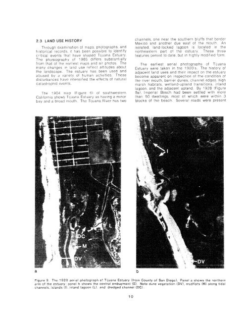
<strong>The</strong> ear!iesl aeria! photographs <strong>of</strong> <strong>Tijuana</strong><br />
<strong>Estuary</strong> were taken in ihe 1920's. <strong>The</strong> history <strong>of</strong><br />
adjacent land uses and their irnpaci on ',he estuary<br />
become apparent on inspection <strong>of</strong> the condition <strong>of</strong><br />
the river mouth, barrier dunes, cihanne! edges. high<br />
rnarsh habitats. wetiand-upland transitions. inland<br />
lagoon. and the adjaceni up!and. By 1928 !Figure<br />
9a!, Imperial Beach had been settled with more<br />
than 50 dweiiings, most <strong>of</strong> which were within 3<br />
blocks <strong>of</strong> the beach. Several roads were present<br />
61gu.e 9 <strong>The</strong> 3928 aerial photograph <strong>of</strong> Tijciana <strong>Estuary</strong> ffrav Courtly <strong>of</strong> San Die~o1. Pafief a shows ttie ~orthecn<br />
arm <strong>of</strong> the estuary paqel b show.; the central embaynsenf fEt Note dune \regetatton EDV) mudflats (MI adcrng tidai<br />
chawels lsiands i!l ~tliand Eag0o.r !hi and dredged channel (DC)


