

The Ecology of Tijuana Estuary, California: An Estuarine Profile
The Ecology of Tijuana Estuary, California: An Estuarine Profile
The Ecology of Tijuana Estuary, California: An Estuarine Profile

Create successful ePaper yourself
Turn your PDF publications into a flip-book with our unique Google optimized e-Paper software.
<strong>The</strong> nearby bridge remained, and extensive<br />
disturbance by vehicle traffic had occurred.<br />
By 1970 several new disturbances were visible.<br />
Additional apartments had been built along the<br />
coast, and the barrier dune no longer supported<br />
good vegetative cover. Large areas <strong>of</strong> dune<br />
washover had developed both north and south <strong>of</strong><br />
the estuary mouth. As is obvious from events <strong>of</strong><br />
the 1980's, this relatively gradual loss <strong>of</strong> dune<br />
vegetation ultimately had an estuary-wide impact.<br />
<strong>The</strong> sewage operation at the inland lagoons had<br />
been abandoned, and saline pannes were obvious<br />
dur~ng the July, dry-season photo. Tidal flushing<br />
was lacking behind the diked areas. <strong>The</strong> mouth<br />
had shifted southward. East <strong>of</strong> the sewage<br />
impoundments, a channel had been dug to direct<br />
street run<strong>of</strong>f into the southernmost lagoon.<br />
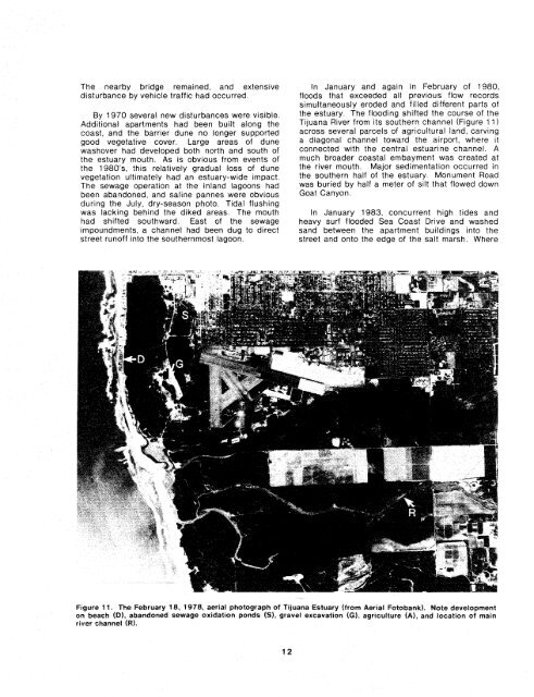
In January and again in February <strong>of</strong> 1980,<br />
floods that exceeded ail previous flow records<br />
simultaneously eroded and filled different parts <strong>of</strong><br />
the estuary. <strong>The</strong> flooding shifted the course <strong>of</strong> the<br />
<strong>Tijuana</strong> River from its southern channel (Figure 1 1)<br />
across several parcels <strong>of</strong> agricultural land, carving<br />
a diagonal channel toward the airport, where it<br />
connected with the central estuarine channel. A<br />
much broader coastal embayment was created at<br />
the river mouth. Major sedimentation occurred in<br />
the southern half <strong>of</strong> the estuary. Monument Road<br />
was buried by half a meter <strong>of</strong> silt that flowed down<br />
Goat Canyon.<br />
In January 1983, concurrent high tides and<br />
heavy surf flooded Sea Coast Drive and washed<br />
sand between the apartment buildings into the<br />
street and onto the edge <strong>of</strong> the salt marsh. Where<br />
Figure 11. <strong>The</strong> February 18, 4 978, aeriaf photograph <strong>of</strong> <strong>Tijuana</strong> <strong>Estuary</strong> (from Aerial Fotobank). Note development<br />
on beach (51, abandoned sewage oxidation ponds (S), gravel excavation (61, agriculture (A), and location af main<br />
river channel (Rl.


