

The Ecology of Tijuana Estuary, California: An Estuarine Profile
The Ecology of Tijuana Estuary, California: An Estuarine Profile
The Ecology of Tijuana Estuary, California: An Estuarine Profile

You also want an ePaper? Increase the reach of your titles
YUMPU automatically turns print PDFs into web optimized ePapers that Google loves.
around the periphery <strong>of</strong> the wetland. However.<br />
there was only a path and no houses on the barrier<br />
dune adjacent to the salt marsh. Signs <strong>of</strong><br />
agriculture in the floodplain are evident upstream<br />
<strong>of</strong> the estuary and north <strong>of</strong> what is now Monurnent<br />
Road.<br />
Several physiographic features that changed in<br />
later years are noted in the photos <strong>of</strong> 1925. 1953,<br />
1964. 1970. 1984. and 1985. In 1928. the dune<br />
had intermittent vegetation extending from what is<br />
now Imperial Beach Slvd. south to the estuary<br />
mouth. This is consistent with Purer's (1936)<br />
description <strong>of</strong> a rich flora that included shrubs<br />
such as lemonadeberry (Rhus integr~folia).<br />
Channels had major bare mudflats along their<br />
periphery. <strong>The</strong> inland lagoons clearly contained<br />
marsh vegetation throughout. Only a small area <strong>of</strong><br />
channel is visible, and that was dredged to link the<br />
lagoon with the estuary. Two islands were present<br />
in the main north-south channel. <strong>The</strong> mouth<br />
(Figure 9b) had tidal flushing through an opening<br />
that angled southwest. A relatively large<br />
embayment was located south <strong>of</strong> the mouth.<br />
although it may have been shallower than indicated<br />
on the 1904 map (Figure 6). What appear to be<br />
large salt pannes were present east <strong>of</strong> the the<br />
inland lagoon.<br />
Changes that took place in the 1960's and<br />
1970's were described using additional air photos;<br />
for the most part, changes remained visible in the<br />
1978 photo (Figure 11). By 1964. apartment<br />
buildings had been constructed along the beach.<br />
extending south to their present limit. Dune<br />
vegetation remained relatively dense south <strong>of</strong> the<br />
apartments. Near the mouth were disturbed areas<br />
and areas <strong>of</strong> bare sand toward the main estuary<br />
channel. A second dike had been built within the<br />
inland lagoon. Sewage was then discharged to two<br />
oxidation ponds before overflowing to the estuary.<br />
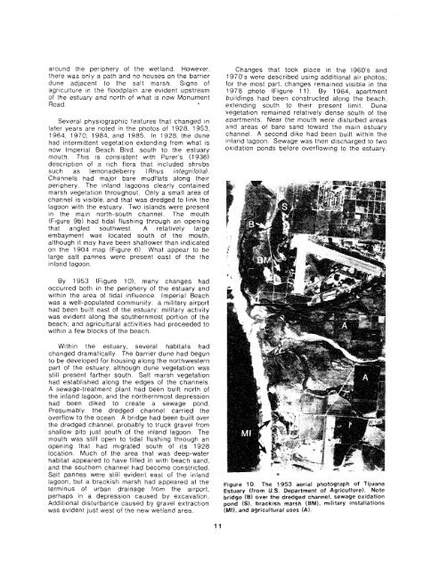
By 1953 (Figure lo), many changes had<br />
occurred both in the periphery <strong>of</strong> the estuary and<br />
within the area <strong>of</strong> tidal influence. Imperial Beach<br />
was a well-populated community: a military airport<br />
had been built east <strong>of</strong> the estuary; military activity<br />
was evident along the southernmost portion <strong>of</strong> the<br />
beach; and agricultural activities had proceeded to<br />
within a few blocks <strong>of</strong> the beach.<br />
Withln the estuary, several habttats had<br />
changed dramatically <strong>The</strong> barr~er dune had begun<br />
to be developed for houslng along the northwestern<br />
part <strong>of</strong> the estuary although dune vegetation was<br />
still present farther south Salt marsh vegetation<br />
had established along the edges <strong>of</strong> the channels<br />
A sewage-treatment plant had been bu~lt north <strong>of</strong><br />
the inland lagoon, and the northernmost depresston<br />
had been diked to create a sewage pond<br />
Presumably the dredged channel carried the<br />
overflow to the ocean A bridge had been built over<br />
the dredged channel, probably to truck gravel from<br />
shallow pits just south <strong>of</strong> the inland lagoon <strong>The</strong><br />
mouth was sttll open to tldal fiushtng through an<br />
opening that had m~grated south <strong>of</strong> its 1928<br />
location Much <strong>of</strong> rhe area that was deep-water<br />
habltat appeared to have filled In with beach sand,<br />
and the southern channel had become constrrcted<br />
Salt Dannes were strli ev~denl east <strong>of</strong> the tnland<br />
iagodn, but a brackish marsh had appeared at the Figure 10, <strong>The</strong> 1953 aerlaf photograph <strong>of</strong> Tfjuana<br />
teimlnus <strong>of</strong> urban drainage from the airport, <strong>Estuary</strong> (from U.S. Department af Agriculture). Mate<br />
perhaps in a depress~on caused by ex~~~ailon bridge (5) aver the dredged channel, sewage ox~dation<br />
Add~ttonal disturbance caused by gravel extractron pond (S), bracktrrh marsh (BM), mrlrtary instaliations<br />
was evldent just west <strong>of</strong> the new wetland area fM1), and agricultural use$ IAf.


